Captain's Blog 5 Oct '24 Major Hurricane Threat for South Florida
Captain's Log
10 October 2024 Auroras over wt360 HQ in Bethlehem PA. Solar Cycle 25 released another G4 magnetic storm sparking Auroras all over the Northern Hemisphere. This was our 5th visible Aurora this year after seeing nothing for over 22 years. Enjoy the timelapse.
5 Oct 2024 Saturday
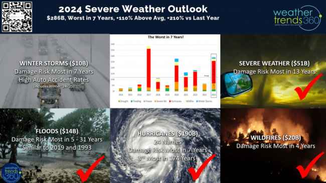
Sadly the U.S. is headed for the most catastrophic losses due to severe weather in 7 years and greatest loss of life since Katrina 19 years ago.
WTI warned of this back in January 2024 and now we face another potential mega-billion loss with soon to be Major Hurricane Milton headed for the Tampa FL area. CLICK ON IMAGES FOR A LARGER VIEW.
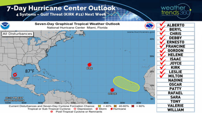
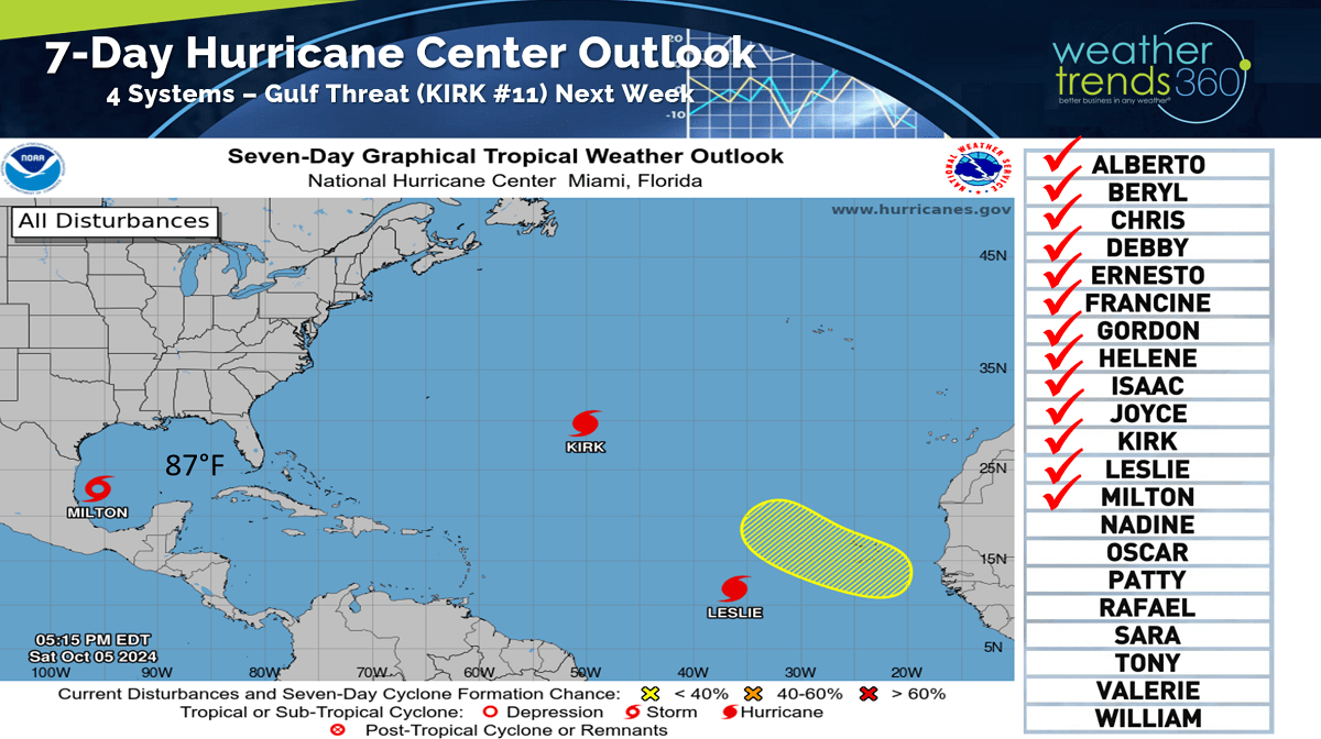
Tropical Storm Milton has formed, and it will intensify rapidly as it takes a very unusual path from the Western Gulf to the Eastern Gulf aiming for the Tampa, FL area with a Wednesday afternoon landfall.
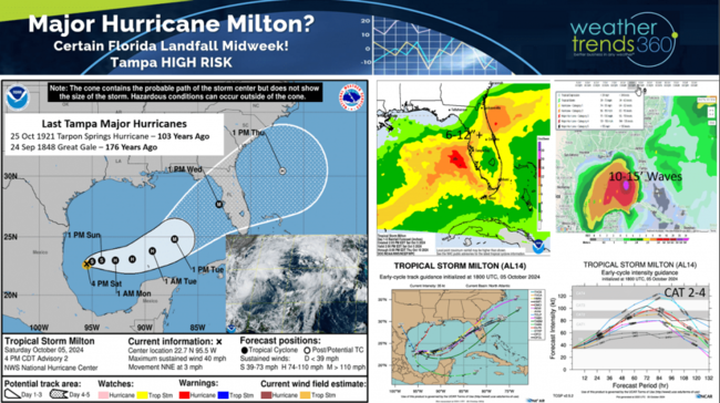
Models all in fairly good agreement on the track and potential explosive intensification as it traverses very warm 87F gulf waters. If Milton goes just north of Tampa it will create a storm surge larger than Helene did which would inundate Downtown Tampa and MacDill AFB. The last time Tampa took a direct hit from a major hurricane was 103 years ago from the Tarpon Springs hurricane and then way back 176 years ago with the Great Gale. CAT 2 Hurricane Kirk in the Central Atlantic is fortunately not headed for the U.S., but very likely to impact the U.K. and France on Wednesday as well.
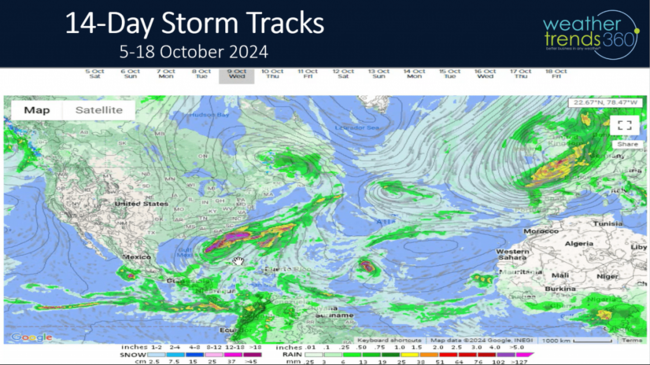
The 14-day storm tracks show a parade of storms coming off Africa but for now most are recurving North and Northeast toward Western Europe as opposed to the U.S.

The Hurricane Season to date is now officially an above average season for almost all metrics with 13 named storms, 1 unnamed storm, 4 U.S. hurricane landfalls soon to be 5 this week, 2 landfalls per year is typical. Despite fewer systems than last year, the damage is exponentially higher due in large part to the flooding from Beryl, Debbie, Francine, Tropical Cyclone #5 and Hellene. Keep in mind some of the biggest and most damaging hurricanes in history have occurred in October.
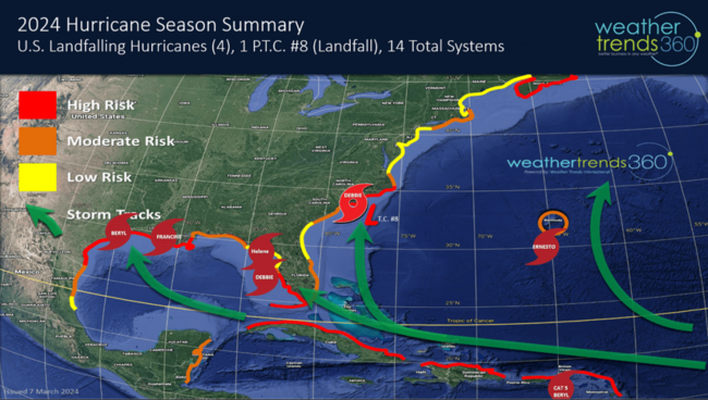
WTI's high risk areas for landfalls here in 2024 have verified well and now Milton likely to have a bigger impact on the Southern half of Florida as warned.
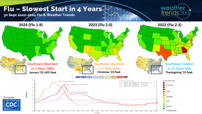
The good news...Flu season is off to the slowest start in 4 years due in large part to warmer and more humid conditions in the Southeast compared to the very cold conditions in 2022 that had Flu surging to a record Thanksgiving spike. This year's much delayed start likely to lead to a January spike in Type A Flu. This will be the 3rd year with Type A the predominant strain so in theory there is some herd immunity in the population.
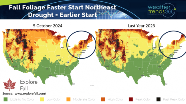
Fall foliage color is trending about two weeks ahead of last year in the Northeast due in part to the very dry Summer-Fall and the coldest conditions in 31 years back in early September. Visit www.explorefall.com for very cool animations of the 2024 forecast and prior year trends.
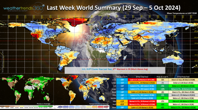
A recap of last week (29 Sep - 5 Oct) across the World shows the U.S. trending -0.9F cooler than last year but still 2nd warmest of the past 39 years. Rainfall was down -52% vs last year, least in 21 years and 4th least of the past 39 years. These are not particularly favorable trends for Fall seasonal merchandise sales. The U.K. and Europe were much more favorable with cool and wet conditions.
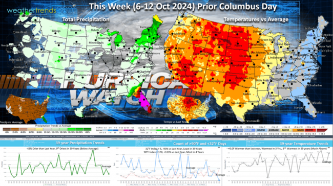
This week (6-12 Oct) prior Columbus Day weekend has all eyes on Hurricane Milton. The Northeast is the most favorable area for Fall seasonal sales with temperatures trending both colder than last year and below average. The Southwest and Plains are very unfavorable. Hurricane Milton likely to bring 6-12"+ rainfall across Florida, so flooding is yet again a major concern. The rest of the country is very dry with a big benefit to farmers harvesting crops.
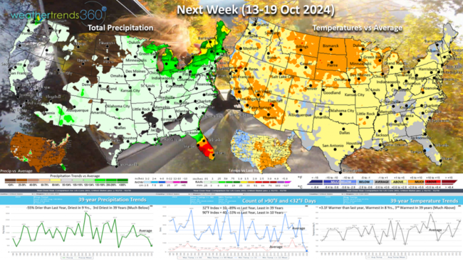
Next week (13-19 Oct) shows some of the extreme warmth waning a bit, but national temperatures still trend +3.1F warmer than last year, warmest in 8 years and 3rd warmest of the past 39. Rainfall again way down -55% vs last year, least in 9 years and 3rd least in 39 years. These are unfavorable trends for seasonal sales. More potential flooding rains in Florida as a stalled front keeps storms tracking over the state.

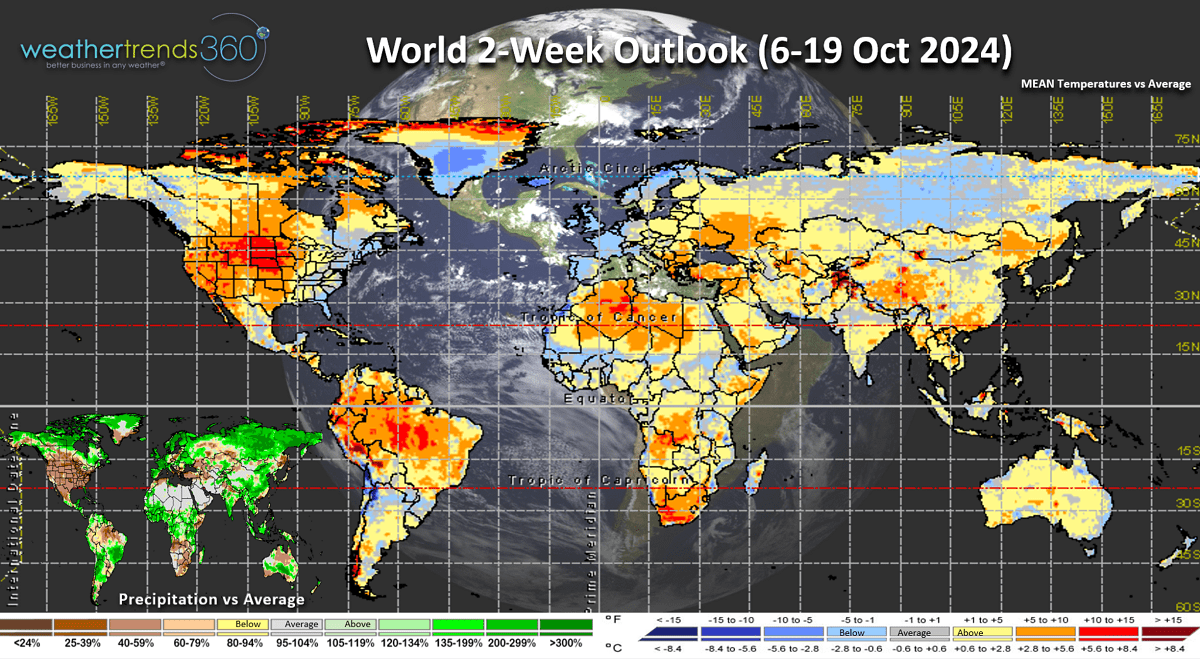
The World 2-week outlook (6-19 Oct) shows the only favorable are for seasonal sales are in the Northeast U.S. and Western Europe. A couple of big remnant hurricanes are likely to impact the U.K. and Western Europe benefiting storm merchandise sales. Home Centers and General Merchandise retailers tend to benefit from Hurricanes while almost all other channels tend to have lower sales as consumers focus on rebuilding vs shopping for Fall merchandise.

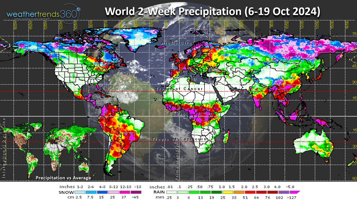
The World 2-week rain/snow outlook shows very dry conditions and expanding drought across the Western half of the U.S. Central Africa remains very wet with frequent tropical waves coming off the continent...eventually these can take a more Westerly track toward the Caribbean in the weeks ahead.
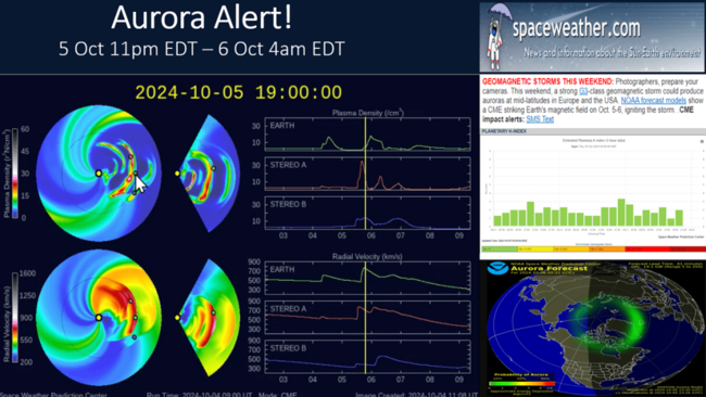
Finally, if you like Auroras, there's a good chance to see them Deep into the U.S. as several strong CMEs are headed our way. First chance is tonight into pre-dawn Sunday. Solar Cycle 25 is peaking, so the opportunity for more Auroras is high in the weeks and months ahead. Check out www.spaceweather.com for updates on the Aurora potential.
Have a great and SAFE week ahead, and don't forget to follow us on social media for frequent updates: Facebook, Twitter, YouTube, Pinterest and Linkedin.
- Captain Kirk out
5 Oct 2024 Saturday
Sadly the U.S. is headed for the most catastrophic losses due to severe weather in 7 years and greatest loss of life since Katrina 19 years ago.

WTI warned of this back in January 2024 and now we face another potential mega-billion loss with soon to be Major Hurricane Milton headed for the Tampa FL area. CLICK ON IMAGES FOR A LARGER VIEW.
Tropical Storm Milton has formed, and it will intensify rapidly as it takes a very unusual path from the Western Gulf to the Eastern Gulf aiming for the Tampa, FL area with a Wednesday afternoon landfall.

Models all in fairly good agreement on the track and potential explosive intensification as it traverses very warm 87F gulf waters. If Milton goes just north of Tampa it will create a storm surge larger than Helene did which would inundate Downtown Tampa and MacDill AFB. The last time Tampa took a direct hit from a major hurricane was 103 years ago from the Tarpon Springs hurricane and then way back 176 years ago with the Great Gale. CAT 2 Hurricane Kirk in the Central Atlantic is fortunately not headed for the U.S., but very likely to impact the U.K. and France on Wednesday as well.
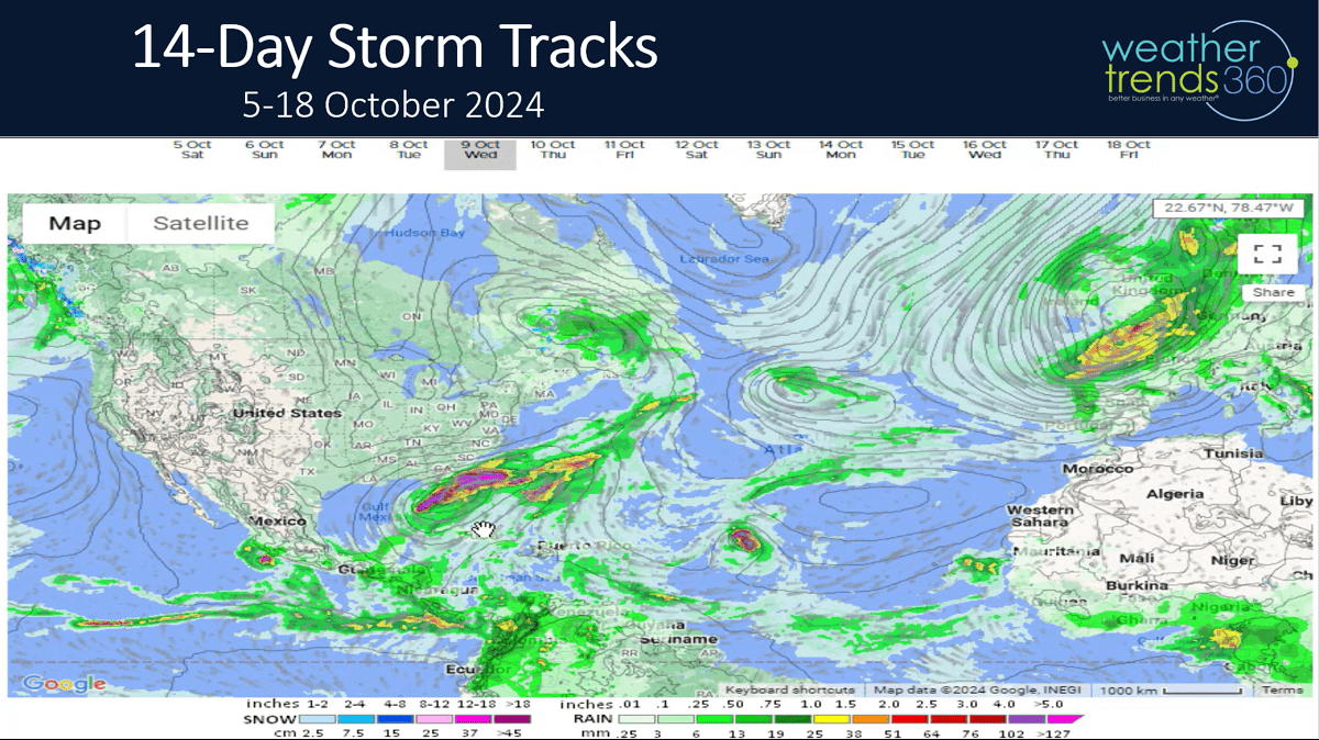
The 14-day storm tracks show a parade of storms coming off Africa but for now most are recurving North and Northeast toward Western Europe as opposed to the U.S.
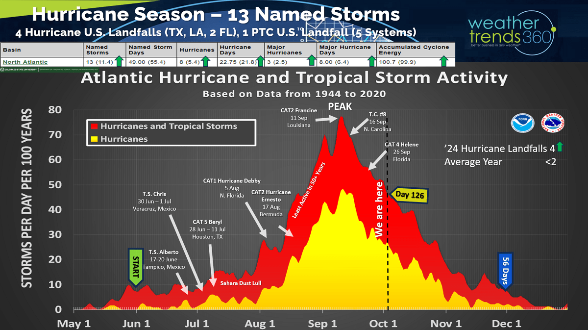
The Hurricane Season to date is now officially an above average season for almost all metrics with 13 named storms, 1 unnamed storm, 4 U.S. hurricane landfalls soon to be 5 this week, 2 landfalls per year is typical. Despite fewer systems than last year, the damage is exponentially higher due in large part to the flooding from Beryl, Debbie, Francine, Tropical Cyclone #5 and Hellene. Keep in mind some of the biggest and most damaging hurricanes in history have occurred in October.
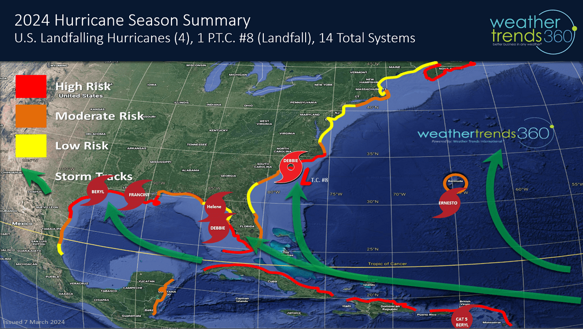
WTI's high risk areas for landfalls here in 2024 have verified well and now Milton likely to have a bigger impact on the Southern half of Florida as warned.

The good news...Flu season is off to the slowest start in 4 years due in large part to warmer and more humid conditions in the Southeast compared to the very cold conditions in 2022 that had Flu surging to a record Thanksgiving spike. This year's much delayed start likely to lead to a January spike in Type A Flu. This will be the 3rd year with Type A the predominant strain so in theory there is some herd immunity in the population.
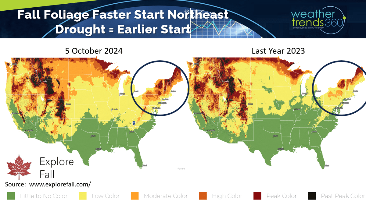
Fall foliage color is trending about two weeks ahead of last year in the Northeast due in part to the very dry Summer-Fall and the coldest conditions in 31 years back in early September. Visit www.explorefall.com for very cool animations of the 2024 forecast and prior year trends.
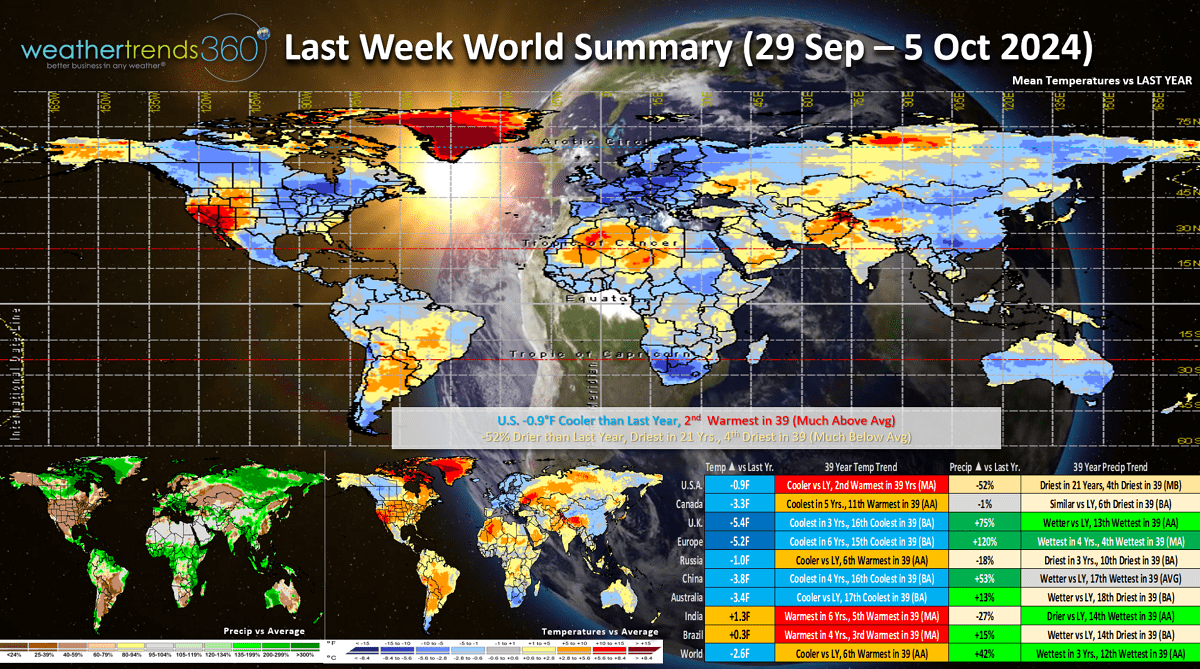
A recap of last week (29 Sep - 5 Oct) across the World shows the U.S. trending -0.9F cooler than last year but still 2nd warmest of the past 39 years. Rainfall was down -52% vs last year, least in 21 years and 4th least of the past 39 years. These are not particularly favorable trends for Fall seasonal merchandise sales. The U.K. and Europe were much more favorable with cool and wet conditions.

This week (6-12 Oct) prior Columbus Day weekend has all eyes on Hurricane Milton. The Northeast is the most favorable area for Fall seasonal sales with temperatures trending both colder than last year and below average. The Southwest and Plains are very unfavorable. Hurricane Milton likely to bring 6-12"+ rainfall across Florida, so flooding is yet again a major concern. The rest of the country is very dry with a big benefit to farmers harvesting crops.
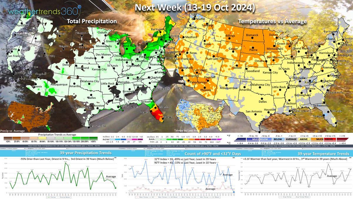
Next week (13-19 Oct) shows some of the extreme warmth waning a bit, but national temperatures still trend +3.1F warmer than last year, warmest in 8 years and 3rd warmest of the past 39. Rainfall again way down -55% vs last year, least in 9 years and 3rd least in 39 years. These are unfavorable trends for seasonal sales. More potential flooding rains in Florida as a stalled front keeps storms tracking over the state.
The World 2-week outlook (6-19 Oct) shows the only favorable are for seasonal sales are in the Northeast U.S. and Western Europe. A couple of big remnant hurricanes are likely to impact the U.K. and Western Europe benefiting storm merchandise sales. Home Centers and General Merchandise retailers tend to benefit from Hurricanes while almost all other channels tend to have lower sales as consumers focus on rebuilding vs shopping for Fall merchandise.
The World 2-week rain/snow outlook shows very dry conditions and expanding drought across the Western half of the U.S. Central Africa remains very wet with frequent tropical waves coming off the continent...eventually these can take a more Westerly track toward the Caribbean in the weeks ahead.
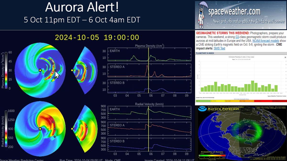
Finally, if you like Auroras, there's a good chance to see them Deep into the U.S. as several strong CMEs are headed our way. First chance is tonight into pre-dawn Sunday. Solar Cycle 25 is peaking, so the opportunity for more Auroras is high in the weeks and months ahead. Check out www.spaceweather.com for updates on the Aurora potential.
Have a great and SAFE week ahead, and don't forget to follow us on social media for frequent updates: Facebook, Twitter, YouTube, Pinterest and Linkedin.
- Captain Kirk out