Captain's Blog 4 Jan '25: Very Cold East, Warmer West
Captain's Log
4 Jan '25: Happy Saturday. :)
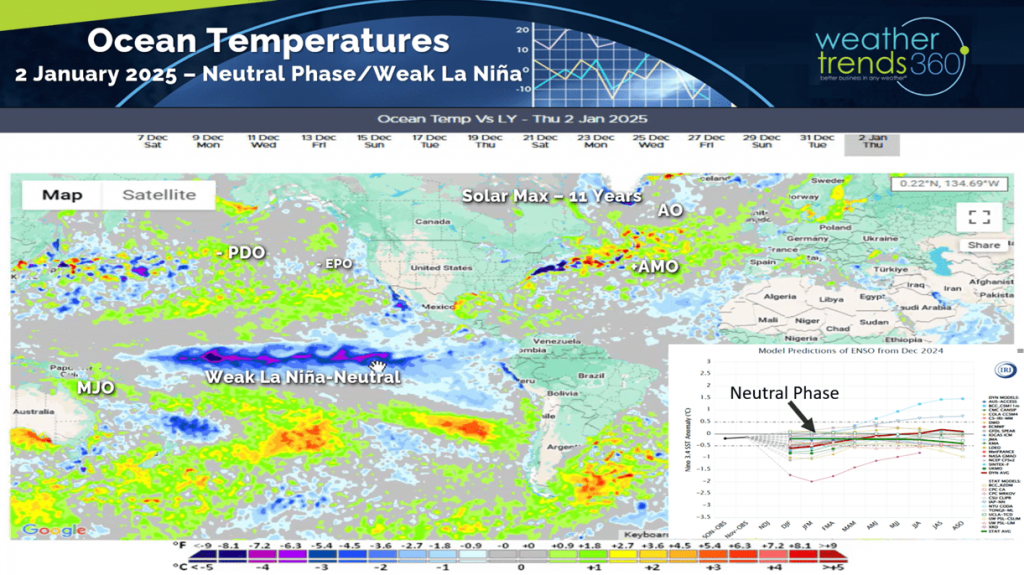
While the weather pattern is somewhat like a weak La Nina, it may never actually be declared La Nina with a weak negative-neutral phase instead. CLICK ON IMAGES FOR A LARGER VIEW.
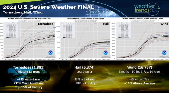
 2024 ended with an uptick in severe weather as tornadoes were the dominant severe weather metric with 1,881 events, the most in 13 years. Hail and Wind cases were down for the year.
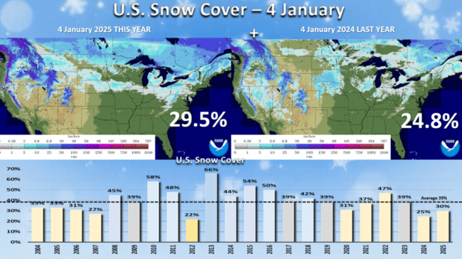
Snow Cover this morning stands at 30% of the U.S. but that will increase dramatically this week with a system sweeping all across the Central U.S. into the Middle Atlantic. Last year 25% of the country had snow on the ground. The biggest change is a bigger snowpack across Southern Canada, Great Lakes and Northeast.
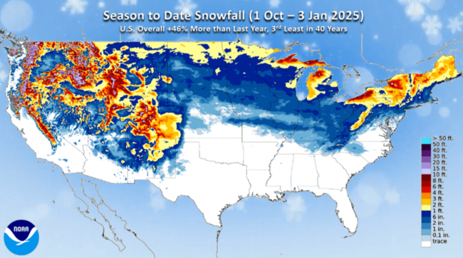
Season-t0-date snowfall across the U.S. is up +46% over last year, but still 3rd least in 40 years. The bigger winner so far this Winter is the interior Northeast where it's been the snowiest in 4 years.
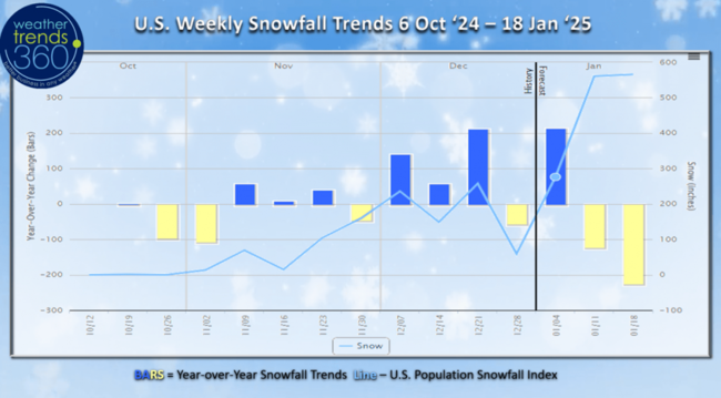
U.S. weekly snowfall trends show the 5-week December having +140% more snow than last year. Despite the next 2-weeks showing less snow than a year ago, it's still well above average and a very snowy period into middle January.
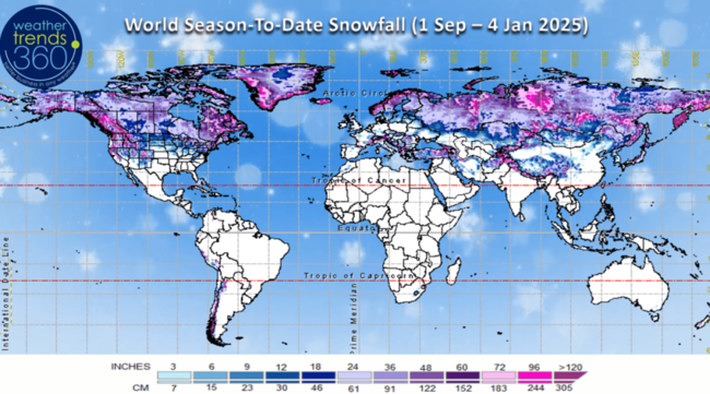
World season-to-date snowfall trends show Europe and the Central U.S. escaping the snow, but that's changing this week in the U.S.
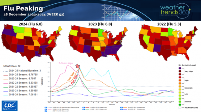
With the cold snap prior to Christmas and holiday travels, Flu has spiked and nearing a peak. It was the slowest start in 3 years, but it surged quickly and likely to peak in early January.
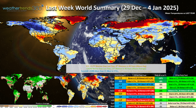
Last week (29 Dec - 4 Jan) across the World shows the U.S. with a warmup after the frigid middle month period. National temperatures trended +2.3F warmer than last year and 8th warmest of the past 40 years. Rainfall was up +247% over last year and 17th wettest of the past 40 years, while snowfall was +388% more than last year, most in 3 years but 14th least of the past 40 years. The Arctic air was moving into Canada while the U.K. was cold, wet and snowy benefiting seasonal merchandise sales.
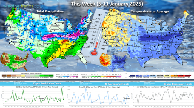
This week (5-11 Jan) the U.S. is much colder trending -6.5F colder than last year, coldest in 8 years and 9th coldest of the past 40 years. A narrow band of very heavy snow will traverse from Kansas to Washington D.C. with freezing rain and ice just south of this band. These are very negative trends for store traffic, but a benefit to must have seasonal items like heaters, ice melt, auto batteries, hot beverages, etc.
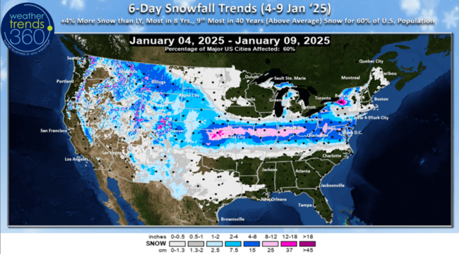
The 6-day snowfall (4-9 Jan) shows the most snow in 8 years, 9th most in 40 years with 60% of the U.S. getting some snow over this period.
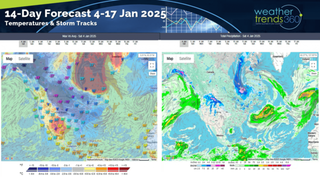
The 14-day storm tracks show continued cold weather in the East with the potential for three more storm systems traversing the U.S. through the 17th.
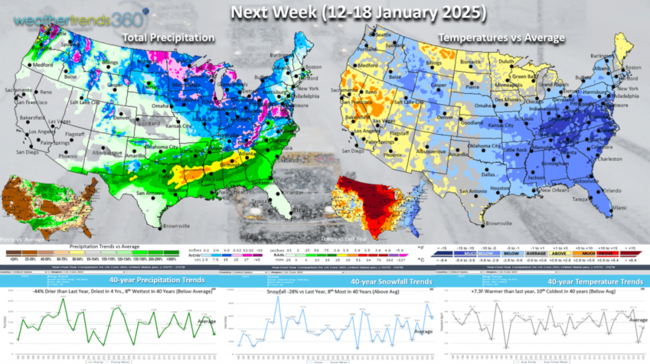
Next week (12-18 Jan) keeps the cold in the East. This was the week last year when the Polar Vortex invaded the Central U.S. As a result, the week trends +7.3F warmer than last year's frigid conditions, but still 10th coldest of the past 40 years. Snowfall is down -28% vs last year's snowy period, but still 8th most snow in 40 years. Rainfall is down -44%, least in 4 years and 8th driest of the past 40 years. Expect East Coast winter merchandise sales to remain favorable, but way down in the Central U.S.
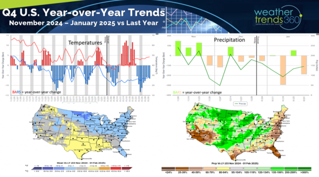
Q4 (Nov - Jan) shows the much stronger December with colder and drier but snowier trends benefiting the holiday shopping season. Going forward warmer/drier Winter weather is better for the overall economy and store traffic, so there is some risk with the colder pattern expected to continue through much of Q1 and Q2 - a high risk 2025 season for retailers.
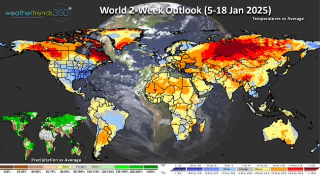
The World 2-week outlook (5-18 Jan) shows the U.S. and the U.K. with the coldest weather trends benefiting seasonal merchandise sales.
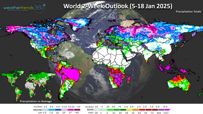
Despite a drier pattern in the U.S., snowfall will still be relatively active.
We hope you have a great start to 2025 and don't forget to follow us on social media for frequent updates: Facebook, Twitter, YouTube, Pinterest and Linkedin.
- Captain Kirk out
While the weather pattern is somewhat like a weak La Nina, it may never actually be declared La Nina with a weak negative-neutral phase instead. CLICK ON IMAGES FOR A LARGER VIEW.
 2024 ended with an uptick in severe weather as tornadoes were the dominant severe weather metric with 1,881 events, the most in 13 years. Hail and Wind cases were down for the year.
Snow Cover this morning stands at 30% of the U.S. but that will increase dramatically this week with a system sweeping all across the Central U.S. into the Middle Atlantic. Last year 25% of the country had snow on the ground. The biggest change is a bigger snowpack across Southern Canada, Great Lakes and Northeast.

Season-t0-date snowfall across the U.S. is up +46% over last year, but still 3rd least in 40 years. The bigger winner so far this Winter is the interior Northeast where it's been the snowiest in 4 years.

U.S. weekly snowfall trends show the 5-week December having +140% more snow than last year. Despite the next 2-weeks showing less snow than a year ago, it's still well above average and a very snowy period into middle January.

World season-to-date snowfall trends show Europe and the Central U.S. escaping the snow, but that's changing this week in the U.S.

With the cold snap prior to Christmas and holiday travels, Flu has spiked and nearing a peak. It was the slowest start in 3 years, but it surged quickly and likely to peak in early January.

Last week (29 Dec - 4 Jan) across the World shows the U.S. with a warmup after the frigid middle month period. National temperatures trended +2.3F warmer than last year and 8th warmest of the past 40 years. Rainfall was up +247% over last year and 17th wettest of the past 40 years, while snowfall was +388% more than last year, most in 3 years but 14th least of the past 40 years. The Arctic air was moving into Canada while the U.K. was cold, wet and snowy benefiting seasonal merchandise sales.

This week (5-11 Jan) the U.S. is much colder trending -6.5F colder than last year, coldest in 8 years and 9th coldest of the past 40 years. A narrow band of very heavy snow will traverse from Kansas to Washington D.C. with freezing rain and ice just south of this band. These are very negative trends for store traffic, but a benefit to must have seasonal items like heaters, ice melt, auto batteries, hot beverages, etc.

The 6-day snowfall (4-9 Jan) shows the most snow in 8 years, 9th most in 40 years with 60% of the U.S. getting some snow over this period.

The 14-day storm tracks show continued cold weather in the East with the potential for three more storm systems traversing the U.S. through the 17th.

Next week (12-18 Jan) keeps the cold in the East. This was the week last year when the Polar Vortex invaded the Central U.S. As a result, the week trends +7.3F warmer than last year's frigid conditions, but still 10th coldest of the past 40 years. Snowfall is down -28% vs last year's snowy period, but still 8th most snow in 40 years. Rainfall is down -44%, least in 4 years and 8th driest of the past 40 years. Expect East Coast winter merchandise sales to remain favorable, but way down in the Central U.S.

Q4 (Nov - Jan) shows the much stronger December with colder and drier but snowier trends benefiting the holiday shopping season. Going forward warmer/drier Winter weather is better for the overall economy and store traffic, so there is some risk with the colder pattern expected to continue through much of Q1 and Q2 - a high risk 2025 season for retailers.

The World 2-week outlook (5-18 Jan) shows the U.S. and the U.K. with the coldest weather trends benefiting seasonal merchandise sales.

Despite a drier pattern in the U.S., snowfall will still be relatively active.

We hope you have a great start to 2025 and don't forget to follow us on social media for frequent updates: Facebook, Twitter, YouTube, Pinterest and Linkedin.
- Captain Kirk out