Captain's Blog 28 Sep '24 Cooler Weather Heading East
Captain's Log
28 Sep '24: Not so Happy Saturday with the devastation in the Southeast.
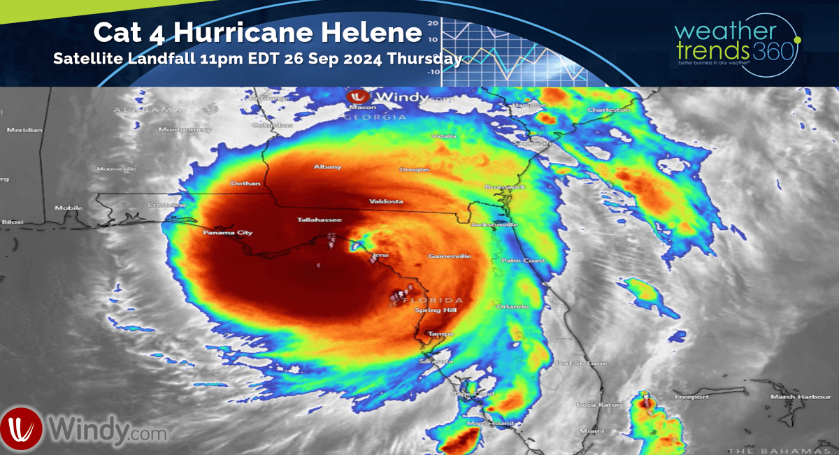
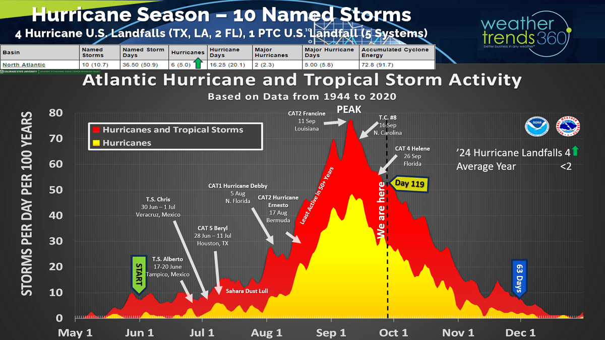
Hurricane Helene was the 5th system and 4th hurricane to make landfall in the U.S. this year as a CAT 4 with catastrophic flooding and damage in the Southeast. The most U.S. hurricane landfalls in 4 years. Sadly at least 45 deaths, so this name will get retired. CLICK ON IMAGES FOR A LARGER VIEW.

We still have over 2 months left with the 2024 hurricane season and we still expect at least one or two more systems to make landfall in the U.S. While the seasonal metrics are near to slightly below average, the 4 land falling hurricanes is well above the average of <2 per year and the most since 2020 when 6 hurricanes impacted the U.S.

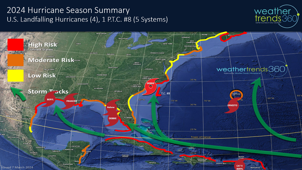
So far TX, FL and the Carolinas have been hardest hit from these systems.
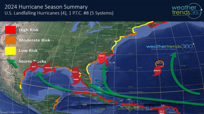
The next name on the list is yours truly - KIRK- and models are hinting at another system developing in the same general area as Helene but more likely to head to the Western Gulf later this week - TBD.

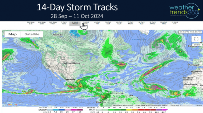
The 14-day storm tracks show an active Atlantic due in part to a favorable MJO tropical cycle that remains favorable well into October.
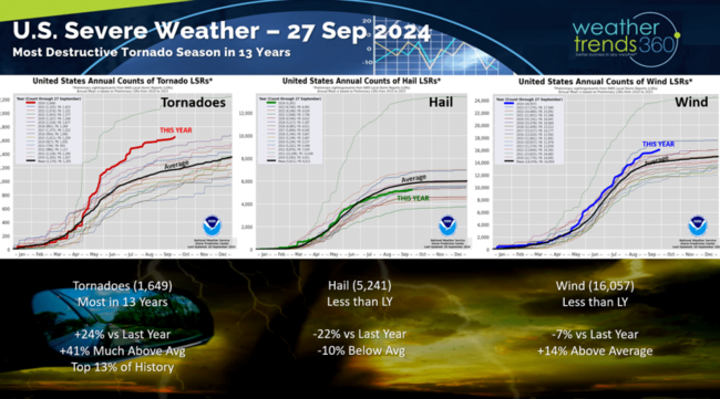
The Severe Weather season added some tornadoes due to Helene with tornados year to date up +24% vs last year, most in 13 years as forecast and the top 13% of history. Hail cases are down -22% and below average while wind events are down but still above average.
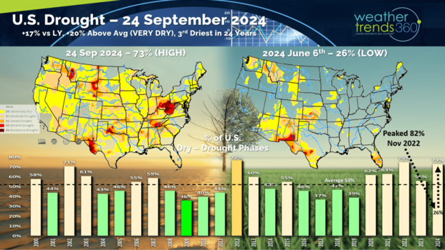
Drought is on a wild ride going from near historic highs in November 2022 when 82% of the country was in dry to drought phases and then plummeted to just 26% dry-drought in early June 2024 and now surging back to 73% of the U.S. in dry to drought like phases. Drought will expand and intensify for the Western half of the U.S. into 2025.
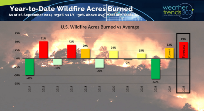
With drought tends to come wildfires and nationally we're already up +32% vs average, +230% vs last year and the most in 7 years. WT360 expects 2025 to be even worse trending the most acres burned in 10 years for the Western half of the country.
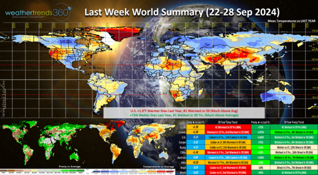
Last week (22-28 Sep) across the World shows the U.S. trending +1.9F warmer than last year and #1 warmest of the past 39 years. Rainfall up +73% over last year and #1 wettest of the past 39 years due in large part to Helene. The U.K. was the most favorable spot for Fall merchandise sales with cold and wet weather.
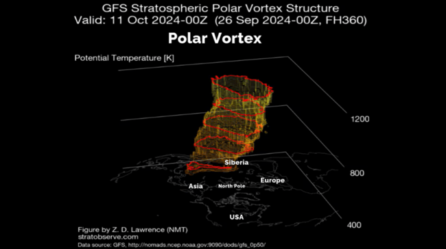
The Polar Vortex at the North Pole continues to develop and almost fully developed. This Winter should have a weaker vortex under a weak La Nina event allowing for more frequent Polar Vortex invasions into the U.S. and Canada.
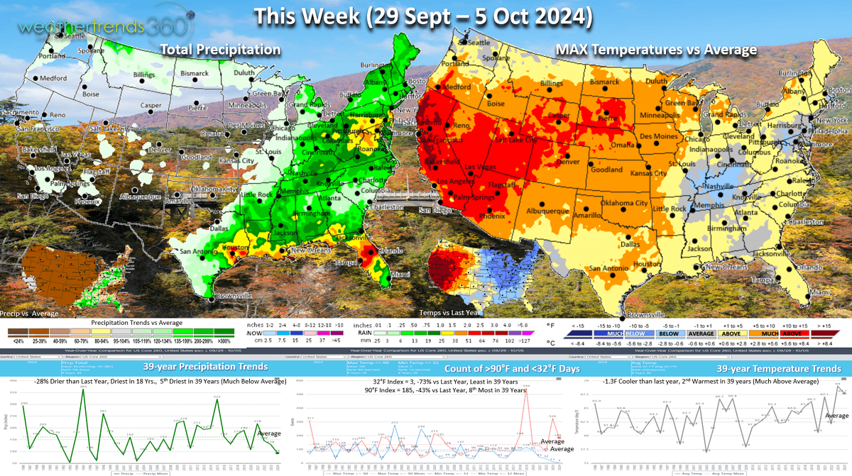
This week (29 Sep - 5 Oct) the U.S. trends -1.3F cooler than last year but still 2nd warmest of the past 39 years. The Eastern half of the U.S. does trend much colder than last year so seasonal demand will be stronger vs very unfavorable hot conditions in the West. Rainfall down -28% vs last year and driest in 18 years nationally. As was the case with Helene, systems can develop very quickly in the Gulf with middle to high 80F water temperatures and models hint at another system developing.

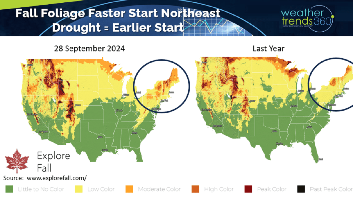
With the drought-like conditions in the Northeast, Fall foliage is at least 2-weeks ahead of last year. The peak is likely to be at least a couple weeks earlier in the Northeast but a couple weeks later in the Upper Midwest. The drought last year in the Upper Midwest had them off to a fast start, a bit slower this year with the much wetter Summer. Check out www.explorefall.com for very cool information on Fall Foliage forecasts.

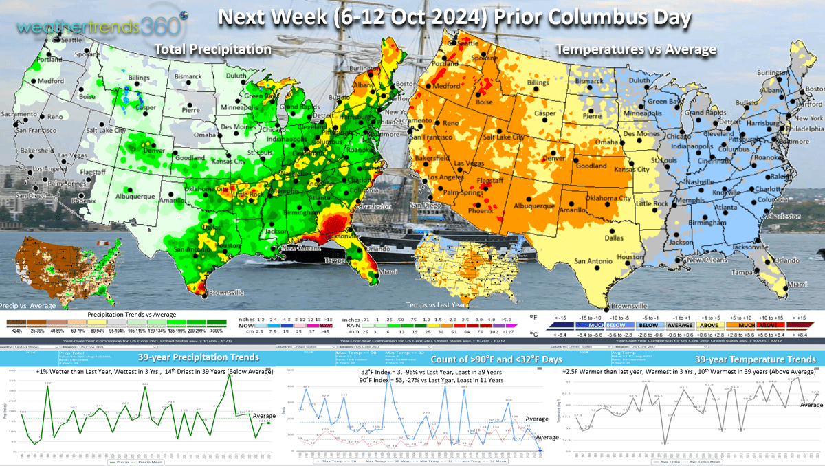
Next Week (6-12 Oct) is the week before Columbus Day and it's a tale of two halves. The East Coast trends the coolest in 12 years while it's still Summer-like out West. National temperatures are +2.5F warmer than last year, warmest in 3 years and 10th warmest of the past 39, but again the Northeast will have stronger YOY sales trends for Fall Merchandise. Rainfall flat to last year, wettest in 3 years and 14th driest of the past 39 years.

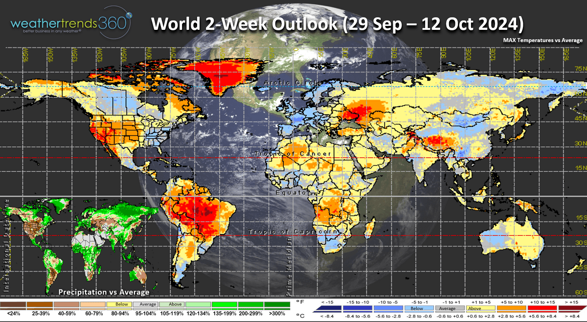
The World 2-week outlook (29 Sep - 12 Oct) shows the Eastern U.S., Central Canada and Europe having generally favorable trends for early Fall category sales. The West is very unfavorable.

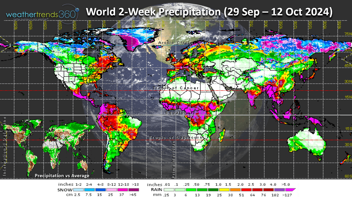
World Precipitation over the next couple weeks show much above average snowfall for Siberia, this is one index that can be an indicator for a colder/snowier earlier start in the U.S.

Have a great week, and don't forget to follow us on social media: Facebook, Twitter, YouTube, Pinterest and Linkedin.
- Captain Kirk out (USAF Gulf War Veteran 1989-1999)
Hurricane Helene was the 5th system and 4th hurricane to make landfall in the U.S. this year as a CAT 4 with catastrophic flooding and damage in the Southeast. The most U.S. hurricane landfalls in 4 years. Sadly at least 45 deaths, so this name will get retired. CLICK ON IMAGES FOR A LARGER VIEW.
We still have over 2 months left with the 2024 hurricane season and we still expect at least one or two more systems to make landfall in the U.S. While the seasonal metrics are near to slightly below average, the 4 land falling hurricanes is well above the average of <2 per year and the most since 2020 when 6 hurricanes impacted the U.S.
So far TX, FL and the Carolinas have been hardest hit from these systems.
The next name on the list is yours truly - KIRK- and models are hinting at another system developing in the same general area as Helene but more likely to head to the Western Gulf later this week - TBD.
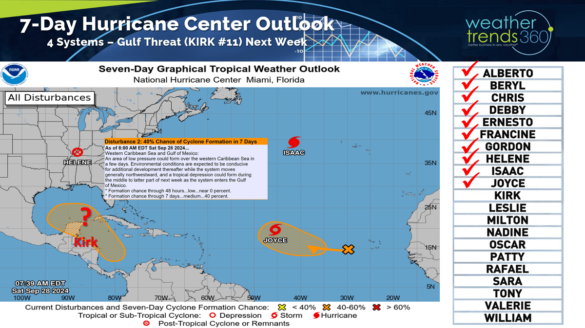
The 14-day storm tracks show an active Atlantic due in part to a favorable MJO tropical cycle that remains favorable well into October.

The Severe Weather season added some tornadoes due to Helene with tornados year to date up +24% vs last year, most in 13 years as forecast and the top 13% of history. Hail cases are down -22% and below average while wind events are down but still above average.

Drought is on a wild ride going from near historic highs in November 2022 when 82% of the country was in dry to drought phases and then plummeted to just 26% dry-drought in early June 2024 and now surging back to 73% of the U.S. in dry to drought like phases. Drought will expand and intensify for the Western half of the U.S. into 2025.

With drought tends to come wildfires and nationally we're already up +32% vs average, +230% vs last year and the most in 7 years. WT360 expects 2025 to be even worse trending the most acres burned in 10 years for the Western half of the country.

Last week (22-28 Sep) across the World shows the U.S. trending +1.9F warmer than last year and #1 warmest of the past 39 years. Rainfall up +73% over last year and #1 wettest of the past 39 years due in large part to Helene. The U.K. was the most favorable spot for Fall merchandise sales with cold and wet weather.

The Polar Vortex at the North Pole continues to develop and almost fully developed. This Winter should have a weaker vortex under a weak La Nina event allowing for more frequent Polar Vortex invasions into the U.S. and Canada.

This week (29 Sep - 5 Oct) the U.S. trends -1.3F cooler than last year but still 2nd warmest of the past 39 years. The Eastern half of the U.S. does trend much colder than last year so seasonal demand will be stronger vs very unfavorable hot conditions in the West. Rainfall down -28% vs last year and driest in 18 years nationally. As was the case with Helene, systems can develop very quickly in the Gulf with middle to high 80F water temperatures and models hint at another system developing.
With the drought-like conditions in the Northeast, Fall foliage is at least 2-weeks ahead of last year. The peak is likely to be at least a couple weeks earlier in the Northeast but a couple weeks later in the Upper Midwest. The drought last year in the Upper Midwest had them off to a fast start, a bit slower this year with the much wetter Summer. Check out www.explorefall.com for very cool information on Fall Foliage forecasts.
Next Week (6-12 Oct) is the week before Columbus Day and it's a tale of two halves. The East Coast trends the coolest in 12 years while it's still Summer-like out West. National temperatures are +2.5F warmer than last year, warmest in 3 years and 10th warmest of the past 39, but again the Northeast will have stronger YOY sales trends for Fall Merchandise. Rainfall flat to last year, wettest in 3 years and 14th driest of the past 39 years.
The World 2-week outlook (29 Sep - 12 Oct) shows the Eastern U.S., Central Canada and Europe having generally favorable trends for early Fall category sales. The West is very unfavorable.
World Precipitation over the next couple weeks show much above average snowfall for Siberia, this is one index that can be an indicator for a colder/snowier earlier start in the U.S.
Have a great week, and don't forget to follow us on social media: Facebook, Twitter, YouTube, Pinterest and Linkedin.
- Captain Kirk out (USAF Gulf War Veteran 1989-1999)