Captain's Blog 27 Sep '25 First Frost Northeast
Captain's Log
27 Sep '25 Happy Saturday. :)
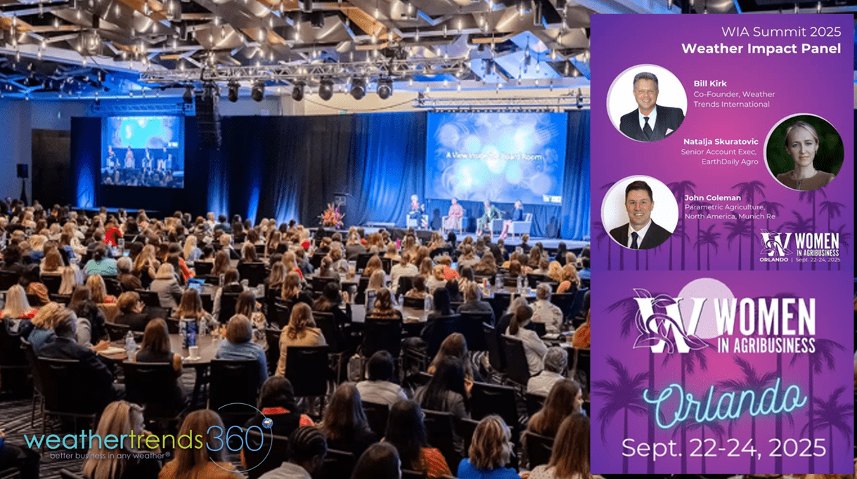
We met a lot of great women Ag business leaders at the Women in Agribusiness Summit in Florida this week. It was an honor to speak about our 2026 Ag outlook on the Weather Impact Panel. Sadly, more price risk for farmers well into 2026. CLICK ON IMAGES FOR A LARGER VIEW

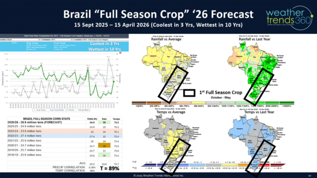
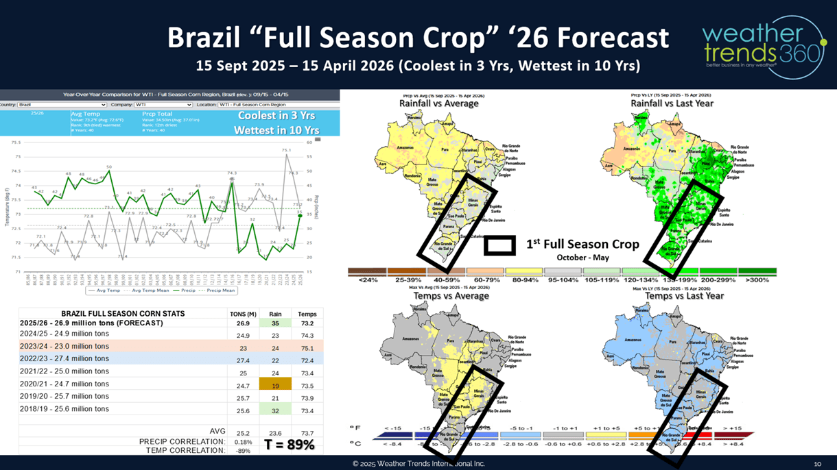
We highlighted our 2026 Brazil crop forecast that shows the wettest conditions in 10-14 years for their Full season and Safrinha crops with record yield potential. This will negatively impact already low corn prices going into Spring 2026.
We talked about how our FarmCast year-ahead daily email report for farmers anywhere on Earth can help mitigate the risk with short term and year-ahead intelligence. FarmCast promotion.

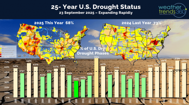
As expected, Drought across the U.S. has expanded rapidly over the past couple months. This developed after the U.S. Corn Belt had already produced record shattering yields after the wettest July in 15 years across the Corn Belt. This sent corn prices plummeting to $3.75 bu/ac lows, but now dry Fall brought a slight bounce to $4.22 bu/ac. These lows will be retested in early 2026 with Brazil's potential record crop on top of a record crop this year. Currently 68% of the U.S. is in dry to drought phases.
The thunderstorms leaving Florida were interesting from 30,000 feet, at least from a meteorologist's point of view. Most don't like thunderstorms while flying. HA

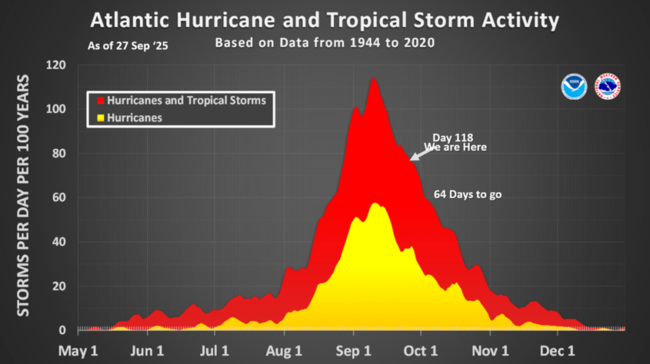
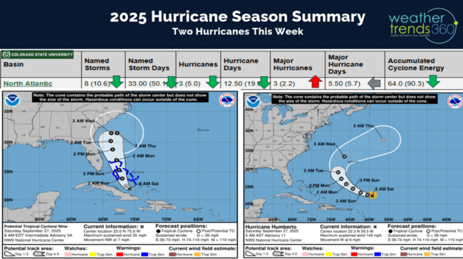
We're day 118 into the Hurricane Season with 64 days left. The tropics have finally gotten a little more interesting with soon to be two hurricanes. The first is #8 Major Hurricane Humberto that will pass close to Bermuda on Tuesday. Bermuda will be in the right front quadrant of the hurricane which is the most dangerous part of the storm.
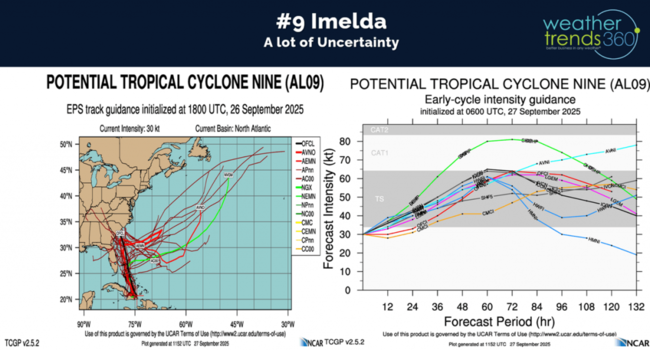
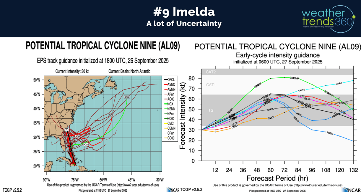
Then #9 Imelda is likely to develop into a CAT 1 hurricane and MAYBE miss the U.S. Southeast Coast as a "Fujiwhara" effect takes place with Humberto pulling Imelda out to sea. Still a lot of uncertainty with this scenario, but biggest impact appears to be some flooding rains for coastal South Carolina midweek.
Models show some confusion on Imelda and now keep it off the coast. TBD on the exact track.
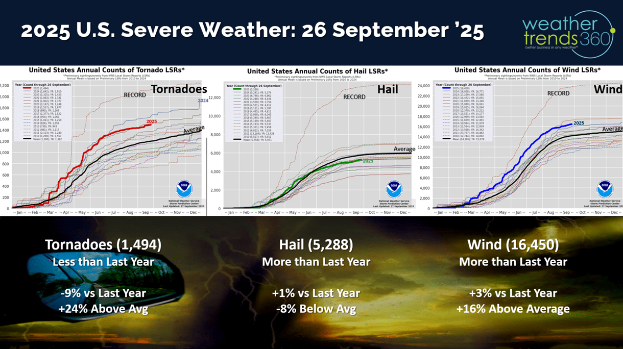
Severe Weather across the U.S. to date shows tornadoes down -9% vs last year, hail up +1% vs last year and wind cases up +3% vs last year.

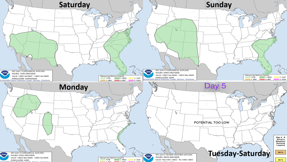
The week ahead severe weather outlook shows generally low risk for severe thunderstorms.

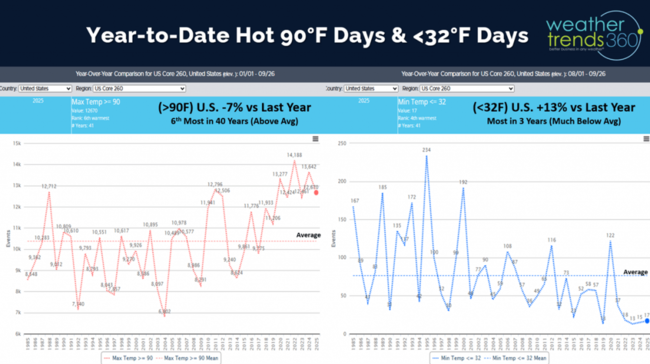
Hot 90F days continue to trend down -7% vs last year, but still 6th most of the past 40 years, while cold days <32F (since 1 Aug) are up +13% vs last year, most in 3 years but still well below average.
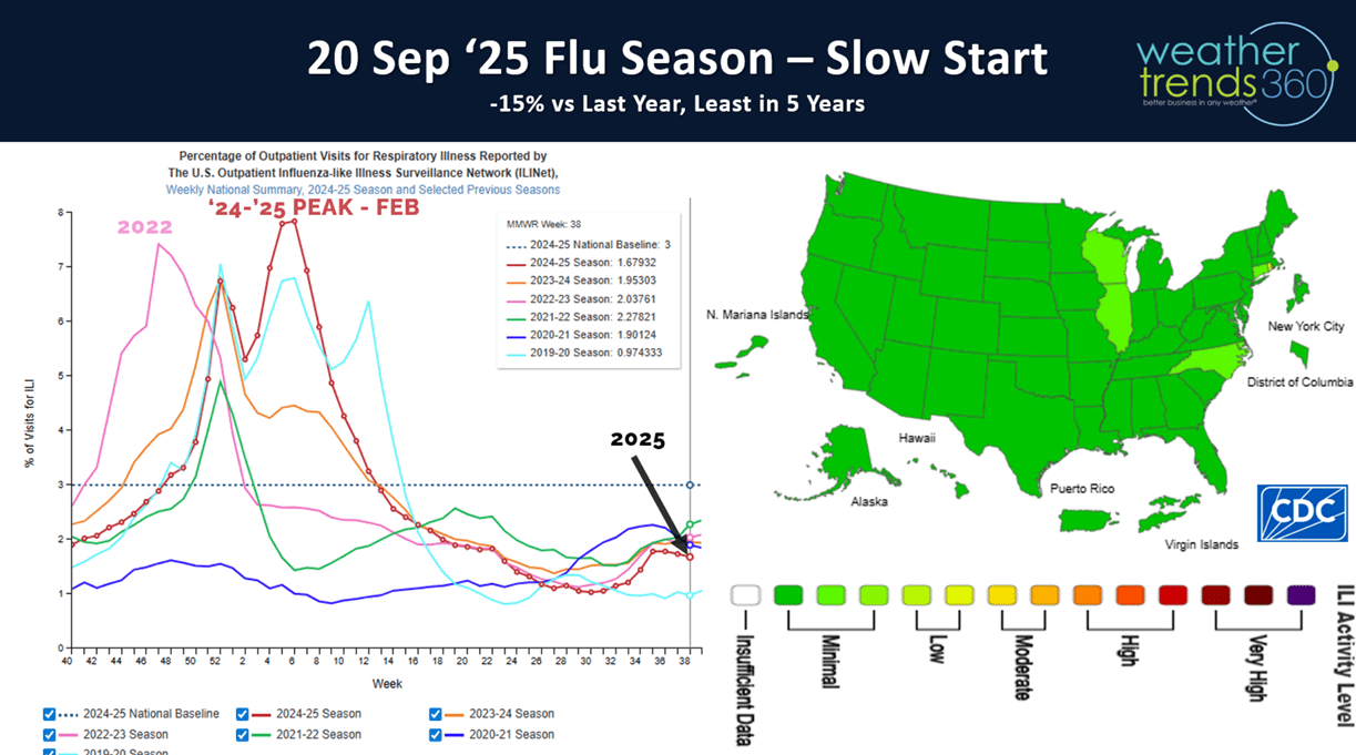
With the warmer weather in the Southeast, FLU is off to the slowest start in 5 years. This is setting up very similarly to Australia's season that had a very late peak in their Spring, a similar setup for the U.S. with a late Winter peak with Type B the most likely strain.

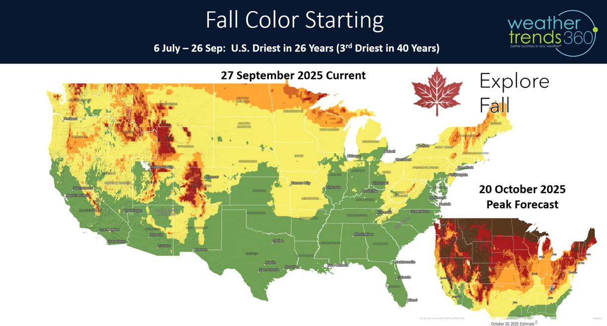
Since 6 July, the U.S. is trending the driest in 26 years which is changing the leaves a bit quicker than normal. The peak Fall color for the U.S. overall is likely in middle to late October. Dry weather can make for beautiful color, but the leaves can also change in stages rather than all at once. The leaves are also much more susceptible to falling off with heavy rain and wind.

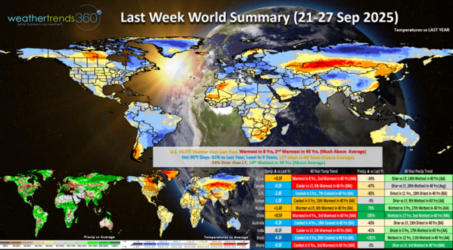
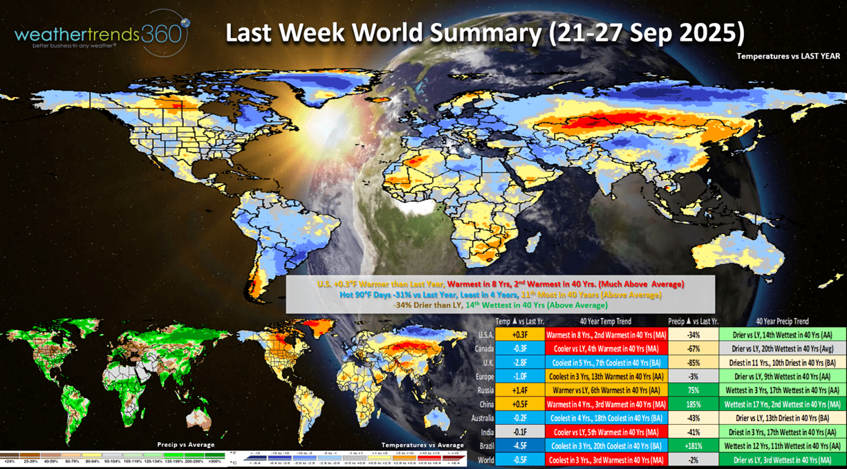
Last week (21-27 Sep) across the World shows the U.S. trending +0.3F warmer than last year, warmest in 8 years and 2nd warmest of the past 40 years. Hot 90F days were down -31% vs last year, and least in 4 years, while rainfall was down -34% but still 14th wettest of the past 40 years. The U.K. had very favorable conditions for Fall seasonal merchandise sales with below average temperatures. Brazil was the wettest in 12 years which benefits their main crop currently planted.
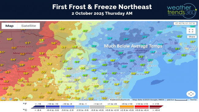
This week (28 Sep - 4 Oct) shows the U.S. trending -0.9F cooler than last year, coolest in 3 years, but still 3rd warmest of the past 40 years. There will be a short lived major cool down in the Northeast mid to late week which help some Fall category sales, the West Coast is also favorably cool and wet. The Central U.S. looks to be very warm, while the Southeast coast watches for impacts from soon to be Hurricane Imelda.
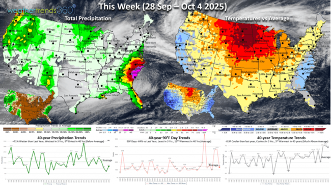
Thursday morning (2 Oct) likely to bring the first frost and some freezes to the Northeast U.S. with temperatures in the 30s and 40s inland away from the big cities.
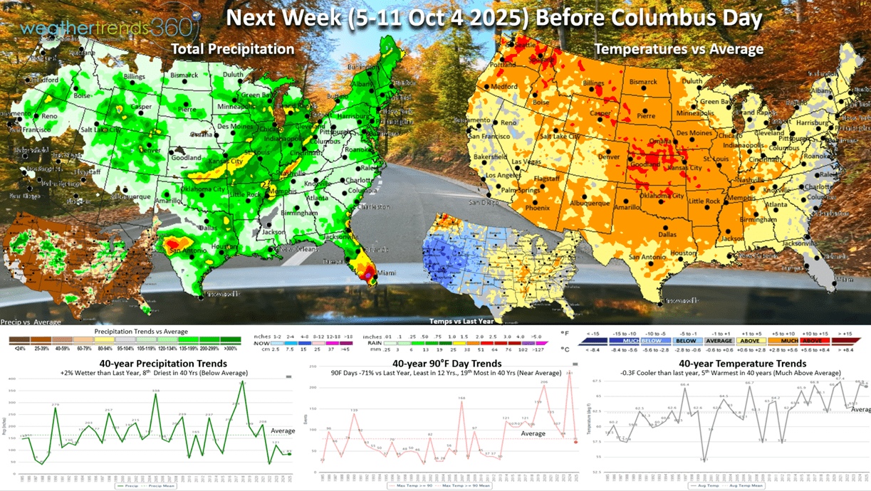
Next week (5-11 Oct) prior Columbus Day shows the U.S. trending -0.3F cooler than last year but still 5th warmest of the past 40 years. Hot 90F days are way down -71% and the least in 12 years, while rainfall is up +2% vs LY but still 8th least in 40 years. These are neutral to slightly negative trends for Fall seasonal sales. The West is the main area showing much colder year-over-year temperatures.

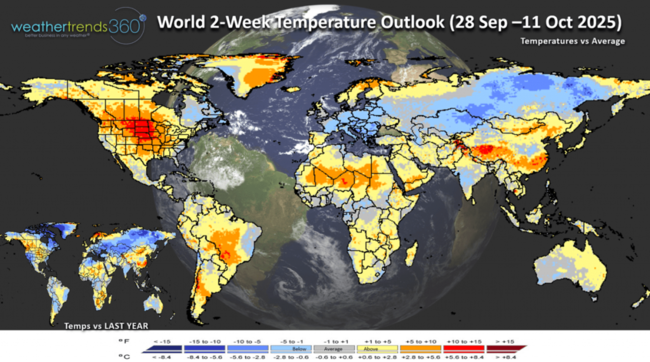
The World 2-week Temperature Outlook (28 Sep - 11 Oct) shows very warm conditions in the Central U.S. with cooler conditions for Eastern Canada and much of Central and Eastern Europe.
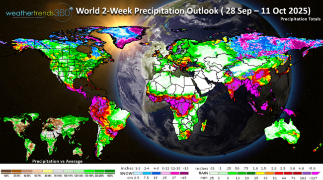
The World 2-week Precipitation Outlook (28 Sep - 11 Oct) shows a generally dry U.S. patter except in the Coastal Southeast and parts of the West.
Have a great week ahead, and don't forget to follow us on social media for frequent updates: Facebook, Twitter(X), YouTube, Pinterest and Linkedin.
- Captain Kirk out
We met a lot of great women Ag business leaders at the Women in Agribusiness Summit in Florida this week. It was an honor to speak about our 2026 Ag outlook on the Weather Impact Panel. Sadly, more price risk for farmers well into 2026. CLICK ON IMAGES FOR A LARGER VIEW
We highlighted our 2026 Brazil crop forecast that shows the wettest conditions in 10-14 years for their Full season and Safrinha crops with record yield potential. This will negatively impact already low corn prices going into Spring 2026.
We talked about how our FarmCast year-ahead daily email report for farmers anywhere on Earth can help mitigate the risk with short term and year-ahead intelligence. FarmCast promotion.

As expected, Drought across the U.S. has expanded rapidly over the past couple months. This developed after the U.S. Corn Belt had already produced record shattering yields after the wettest July in 15 years across the Corn Belt. This sent corn prices plummeting to $3.75 bu/ac lows, but now dry Fall brought a slight bounce to $4.22 bu/ac. These lows will be retested in early 2026 with Brazil's potential record crop on top of a record crop this year. Currently 68% of the U.S. is in dry to drought phases.

The thunderstorms leaving Florida were interesting from 30,000 feet, at least from a meteorologist's point of view. Most don't like thunderstorms while flying. HA

We're day 118 into the Hurricane Season with 64 days left. The tropics have finally gotten a little more interesting with soon to be two hurricanes. The first is #8 Major Hurricane Humberto that will pass close to Bermuda on Tuesday. Bermuda will be in the right front quadrant of the hurricane which is the most dangerous part of the storm.

Then #9 Imelda is likely to develop into a CAT 1 hurricane and MAYBE miss the U.S. Southeast Coast as a "Fujiwhara" effect takes place with Humberto pulling Imelda out to sea. Still a lot of uncertainty with this scenario, but biggest impact appears to be some flooding rains for coastal South Carolina midweek.

Models show some confusion on Imelda and now keep it off the coast. TBD on the exact track.
Severe Weather across the U.S. to date shows tornadoes down -9% vs last year, hail up +1% vs last year and wind cases up +3% vs last year.
The week ahead severe weather outlook shows generally low risk for severe thunderstorms.
Hot 90F days continue to trend down -7% vs last year, but still 6th most of the past 40 years, while cold days <32F (since 1 Aug) are up +13% vs last year, most in 3 years but still well below average.

With the warmer weather in the Southeast, FLU is off to the slowest start in 5 years. This is setting up very similarly to Australia's season that had a very late peak in their Spring, a similar setup for the U.S. with a late Winter peak with Type B the most likely strain.
Since 6 July, the U.S. is trending the driest in 26 years which is changing the leaves a bit quicker than normal. The peak Fall color for the U.S. overall is likely in middle to late October. Dry weather can make for beautiful color, but the leaves can also change in stages rather than all at once. The leaves are also much more susceptible to falling off with heavy rain and wind.
Last week (21-27 Sep) across the World shows the U.S. trending +0.3F warmer than last year, warmest in 8 years and 2nd warmest of the past 40 years. Hot 90F days were down -31% vs last year, and least in 4 years, while rainfall was down -34% but still 14th wettest of the past 40 years. The U.K. had very favorable conditions for Fall seasonal merchandise sales with below average temperatures. Brazil was the wettest in 12 years which benefits their main crop currently planted.
This week (28 Sep - 4 Oct) shows the U.S. trending -0.9F cooler than last year, coolest in 3 years, but still 3rd warmest of the past 40 years. There will be a short lived major cool down in the Northeast mid to late week which help some Fall category sales, the West Coast is also favorably cool and wet. The Central U.S. looks to be very warm, while the Southeast coast watches for impacts from soon to be Hurricane Imelda.
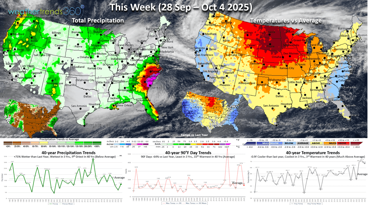
Thursday morning (2 Oct) likely to bring the first frost and some freezes to the Northeast U.S. with temperatures in the 30s and 40s inland away from the big cities.

Next week (5-11 Oct) prior Columbus Day shows the U.S. trending -0.3F cooler than last year but still 5th warmest of the past 40 years. Hot 90F days are way down -71% and the least in 12 years, while rainfall is up +2% vs LY but still 8th least in 40 years. These are neutral to slightly negative trends for Fall seasonal sales. The West is the main area showing much colder year-over-year temperatures.
The World 2-week Temperature Outlook (28 Sep - 11 Oct) shows very warm conditions in the Central U.S. with cooler conditions for Eastern Canada and much of Central and Eastern Europe.

The World 2-week Precipitation Outlook (28 Sep - 11 Oct) shows a generally dry U.S. patter except in the Coastal Southeast and parts of the West.

Have a great week ahead, and don't forget to follow us on social media for frequent updates: Facebook, Twitter(X), YouTube, Pinterest and Linkedin.
- Captain Kirk out