Captain's Blog 26 Oct '24 Wintry West, Hope for Rain East
Captain's Log
26 Oct '24: Happy Saturday. :)
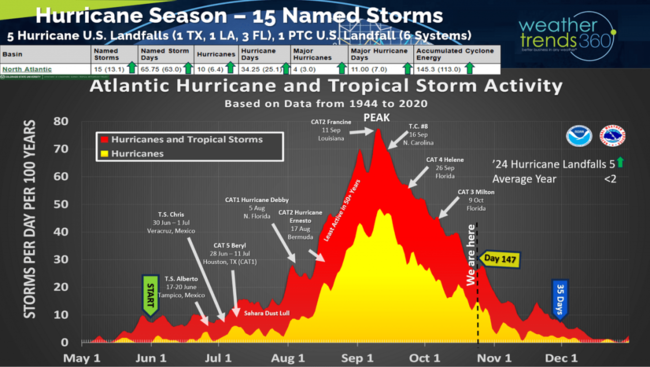
Hurricane season is winding down, but the MJO tropical pulse cycle becomes much more favorable in early November with a couple Atlantic hurricanes likely to develop as a result. Season-t0-date metrics are all above average with the number of landfalling hurricanes (5) well above average along with catastrophic damage not seen since 2017. CLICK ON IMAGES FOR A LARGER VIEW.
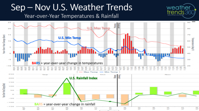
The most favorable week for retail/seasonal sales was the first week of September when the U.S. trended much colder and wetter than last year with the Northeast the coldest in over 40 years up until 11 September. Late September - Early October was another brief period of favorable weather with both cooler and much wetter conditions due in part to Hurricane Hellene. The next colder/wetter period is likely in middle November and then softer again for Thanksgiving with warmer/drier conditions followed by a much more favorable December.
Last week (20-26 Oct) across the World shows the U.S. flip flopping back to a warmer pattern after the briefly cooler weather in middle October. The U.S. overall trended +0.5F warmer than last year and #1 warmest of the past 39 years with rainfall also the #1 driest of the past 39 years nationally. These are unfavorable trends for retail seasonal sales, but a plus to consumable food and beverage categories, home center and outdoor construction categories and in-dining restaurants.
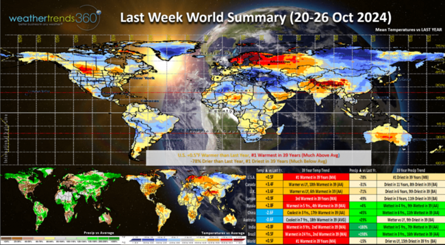
The pattern looks a bit La Niña like with wetter conditions in Asia and drier conditions here in North America. Siberia continues to get well above average snowfall, one index favoring a colder Q4 in North America.
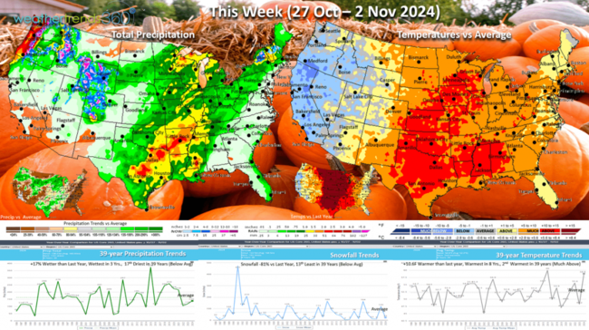
This week (27 Oct - 2 Nov) The weekend (26-27 Oct) was the coldest in 6 years for the Northeast after a very hot week last week - the best region for Fall seasonal sales. Now the cooler and snowier weather shifts to the West Coast as the Central U.S. heats up. Finally some hope for heavier rainfall after the driest September - October in many decades and some 129 years record dry. The U.S. overall trends +10.6F warmer than last year's very cold end to Q3, warmest in 8 years and 2nd warmest of the past 39 years. Rainfall is up +17% vs last year, most in 3 years and 17th driest of the past 39 but heavier rain for the Central U.S. and New England.
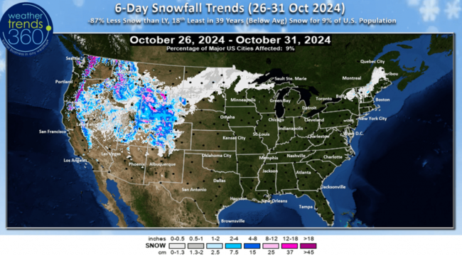
The 6-day snowfall outlook (26-31 Oct) shows heavy mountain snows in the West, but only 9% of the U.S. population getting snow. Snowfall still down -87% vs last year's very snowy end to October.
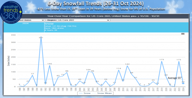
Last year snowfall to end October was tied for the 2nd most in 39 years, this year 18th least in 39 years.
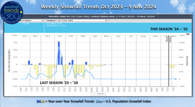
Weekly snowfall trends from last Winter into the current week, shows the heavy snow at the end of October last year and then a long lull until Middle January. The three snowiest weeks were in middle January with the Polar Vortex, middle February and late March. This year likely to get off to a 4-week earlier start with bigger snowfall by the middle of December.
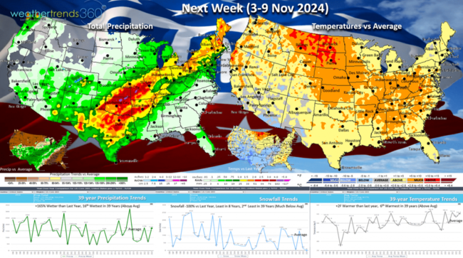
Next week (3-9 Nov) shows the U.S. trending +2F warmer than last year and 6th warmest of the past 39 years with rainfall up +165% and 16th wettest of the past 39 years. Haven't said WET much since Helene and Milton. The heaviest rain will be along a cold front from Texas to New England - much needed! The week does turn a little cooler behind this front mid to late week.

Next weekend is also the end of Daylight Savings Time as we turn the clocks back on 3 November Sunday at 2am.
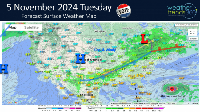
The early election day outlook shows the cold front stretching from Texas to New England with the potential for the heaviest rainfall for many in over two months. Also notice the hurricane off the Southeast Coast which would be named Patty (#16). There have only bee three U.S. landfalling hurricanes in November dating back 174 years, so the risk is usually low.
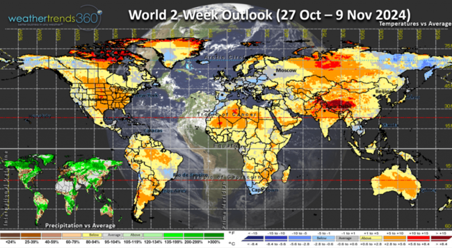
The World 2-week outlook (27 Oct - 9 Nov) shows a warm pattern other than Northeast Siberia and a cooler Europe.
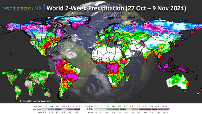
Favorable rainfall in Brazil for their full season Corn crop underway and finally the heavier rain potential for the Texas to New England areas.
Have a great week ahead, and don't forget to follow us on social media for frequent updates: Facebook, Twitter, YouTube, Pinterest and Linkedin.
- Captain Kirk out
Hurricane season is winding down, but the MJO tropical pulse cycle becomes much more favorable in early November with a couple Atlantic hurricanes likely to develop as a result. Season-t0-date metrics are all above average with the number of landfalling hurricanes (5) well above average along with catastrophic damage not seen since 2017. CLICK ON IMAGES FOR A LARGER VIEW.

The most favorable week for retail/seasonal sales was the first week of September when the U.S. trended much colder and wetter than last year with the Northeast the coldest in over 40 years up until 11 September. Late September - Early October was another brief period of favorable weather with both cooler and much wetter conditions due in part to Hurricane Hellene. The next colder/wetter period is likely in middle November and then softer again for Thanksgiving with warmer/drier conditions followed by a much more favorable December.

Last week (20-26 Oct) across the World shows the U.S. flip flopping back to a warmer pattern after the briefly cooler weather in middle October. The U.S. overall trended +0.5F warmer than last year and #1 warmest of the past 39 years with rainfall also the #1 driest of the past 39 years nationally. These are unfavorable trends for retail seasonal sales, but a plus to consumable food and beverage categories, home center and outdoor construction categories and in-dining restaurants.

The pattern looks a bit La Niña like with wetter conditions in Asia and drier conditions here in North America. Siberia continues to get well above average snowfall, one index favoring a colder Q4 in North America.

This week (27 Oct - 2 Nov) The weekend (26-27 Oct) was the coldest in 6 years for the Northeast after a very hot week last week - the best region for Fall seasonal sales. Now the cooler and snowier weather shifts to the West Coast as the Central U.S. heats up. Finally some hope for heavier rainfall after the driest September - October in many decades and some 129 years record dry. The U.S. overall trends +10.6F warmer than last year's very cold end to Q3, warmest in 8 years and 2nd warmest of the past 39 years. Rainfall is up +17% vs last year, most in 3 years and 17th driest of the past 39 but heavier rain for the Central U.S. and New England.

The 6-day snowfall outlook (26-31 Oct) shows heavy mountain snows in the West, but only 9% of the U.S. population getting snow. Snowfall still down -87% vs last year's very snowy end to October.

Last year snowfall to end October was tied for the 2nd most in 39 years, this year 18th least in 39 years.

Weekly snowfall trends from last Winter into the current week, shows the heavy snow at the end of October last year and then a long lull until Middle January. The three snowiest weeks were in middle January with the Polar Vortex, middle February and late March. This year likely to get off to a 4-week earlier start with bigger snowfall by the middle of December.

Next week (3-9 Nov) shows the U.S. trending +2F warmer than last year and 6th warmest of the past 39 years with rainfall up +165% and 16th wettest of the past 39 years. Haven't said WET much since Helene and Milton. The heaviest rain will be along a cold front from Texas to New England - much needed! The week does turn a little cooler behind this front mid to late week.

Next weekend is also the end of Daylight Savings Time as we turn the clocks back on 3 November Sunday at 2am.

The early election day outlook shows the cold front stretching from Texas to New England with the potential for the heaviest rainfall for many in over two months. Also notice the hurricane off the Southeast Coast which would be named Patty (#16). There have only bee three U.S. landfalling hurricanes in November dating back 174 years, so the risk is usually low.

The World 2-week outlook (27 Oct - 9 Nov) shows a warm pattern other than Northeast Siberia and a cooler Europe.

Favorable rainfall in Brazil for their full season Corn crop underway and finally the heavier rain potential for the Texas to New England areas.
Have a great week ahead, and don't forget to follow us on social media for frequent updates: Facebook, Twitter, YouTube, Pinterest and Linkedin.
- Captain Kirk out