Captain's Blog 2 Nov '24 Winter West and WET East
Captain's Log
2 Nov 2024: Happy Saturday. :)
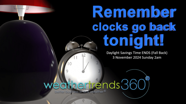
Don't forget to turn your clocks back tonight as Daylight Savings Time ends 2am Sunday morning. CLICK ON IMAGES FOR A LARGER VIEW.
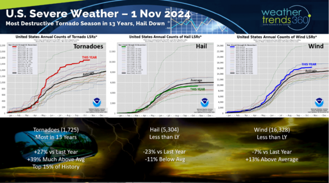
A recap of severe weather to date shows tornadoes (1,725) have been the most in 13 years, +27% over last year, +39% above average and in the top 15% of history. Hail (5,304) is down -23% and -11% below average while winds cases (16,328) are -7% below last year but still +13% above average.
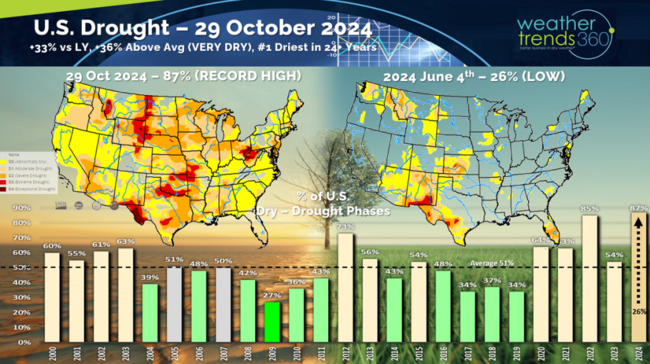
Drought has surged from the very wet conditions back on 4 June when only 26% of the U.S. was in dry to drought phases, now as of 29 October the U.S. has surged to 87% of the country in dry to drought phases, the most in 24+ years.
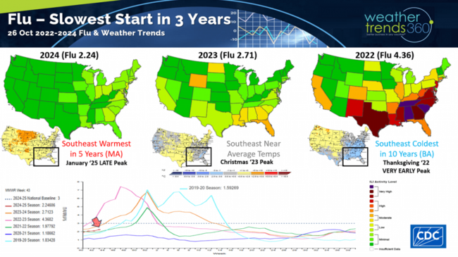
Flu is off to the slowest start in 3 years due in large part to much warmer weather in the Southeast U.S. where Flu typical starts. This time in 2022 the U.S. was off to a near record fast start that led to a Thanksgiving huge peak. Last year peaked after Christmas and this year likely to peak in January. This is good news for the core holiday shopping season from November to Christmas.
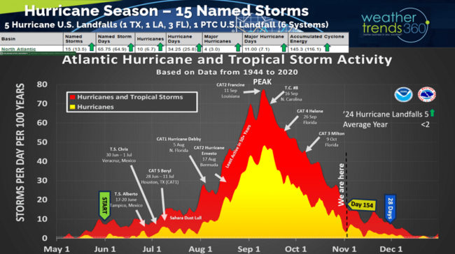
The 2024 Hurricane Season remains above average in all metrics with just 28 days left.
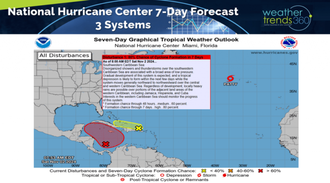
The National Hurricane Center is watching 3 systems with the West Caribbean development showing some risk to the U.S. Gulf Coast - TBD. The MJO tropical pulse cycle is becoming favorable again with more systems possible going into middle November as seen on the 14-day storm track forecast.
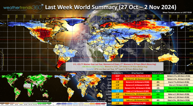
Last week (27 Oct -2 Nov) across the World shows a very warm U.S. but finally some rain for some. The U.S. overall trended +10.2F warmer than last year, warmest in 8 years and 2nd warmest of the past 39 years. Rainfall was up +8% vs last year, most in 3 years but 16th driest of the past 39 years. Snowfall was down -87% vs last year and 12th least of the past 39 years. The weekly pattern was volatile with huge surges of warmth midweek, but then the coolest weekend in 6 years in the Northeast.
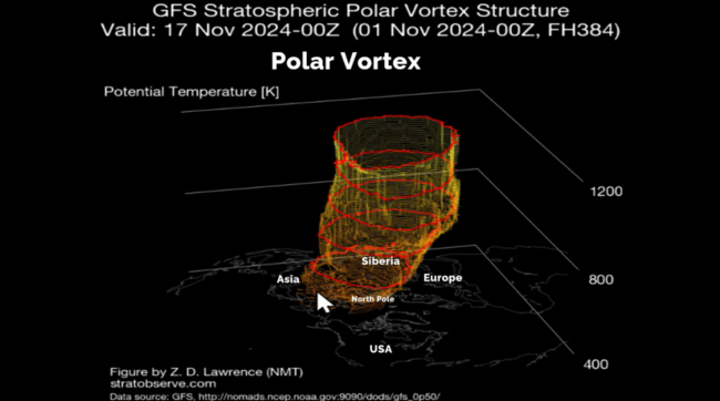
The Polar Vortex is full developed but showing signs of a wobble that will likely bring colder weather to Alaska and the Western half of the U.S. over the next couple weeks.
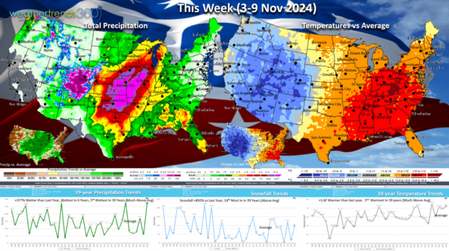
This week (3-9 Nov) shows the U.S. trending +1.6F warmer than last year and 3rd warmest in 39 years, but it's a tale of two halves with Winter in the West and very warm in the East with stormy conditions in the middle. Rainfall up a whopping +377% over last year, most in 6 years and 3rd most in 39 years - welcome relief from the prolonged very dry Fall. Snowfall surges as well with +892% more than last year and 14th most of the past 39 years. The week remains volatile with the warmest part of the week in the middle and then another cooler weekend in the East.
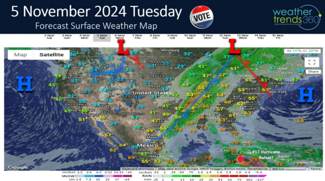
Tuesday November 5th shows the very slow moving cold front stuck from Texas to Michigan with heavy rain and thunderstorms. Much cooler west and warm and windy East as High Pressure blocks this front from making to the East Coast until later in the week. Need to watch what could become Hurricane Rafael heading toward the Gulf of Mexico.
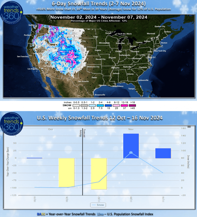
The 6-day (2-7 Nov) snowfall outlook shows frequent snow events in the Rockies with the 6-day snowfall trending up +916% over last year, 16th most in 39 years with 12% of the U.S. population getting some snow. This has the middle November period showing much snowier trends than last year.
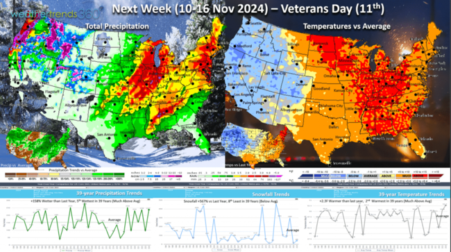
Next week (10-16 Nov) shows the same general pattern with colder and snowier conditions West and warm but WET conditions East. This is a good chance to finally bring much needed rain to drought parched areas in the Northeast. For the U.S. overall, the week trends +2.3F warmer than last year, 2nd warmest in 39 years. Rainfall up +158% over last year and 5th wettest in 39 years with much above rainfall suggesting the drought cycle weather pattern is breaking down. Snowfall again up +567% vs last year but still 8th least of the past 39 years.
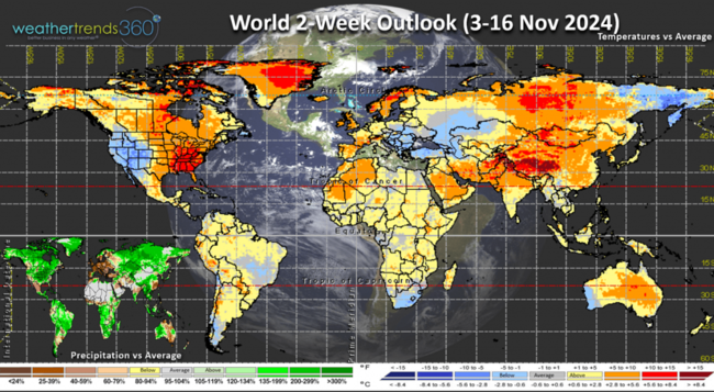
The World 2-week outlook (3-16 Nov) shows the most favorable spots for Fall seasonal merchandise sales in the Western half of the U.S. and in Eastern Europe.
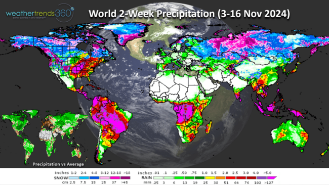
World precipitation (3-16 Nov) shows a very wet North and South America pattern. Heavy snow is widespread across the Northern tier of the Northern Hemisphere from Alaska to Siberia.
Have a great week and don't forget to follow us on social media for frequent updates: Facebook, Twitter, YouTube, Pinterest and Linkedin.
- Captain Kirk out
Don't forget to turn your clocks back tonight as Daylight Savings Time ends 2am Sunday morning. CLICK ON IMAGES FOR A LARGER VIEW.

A recap of severe weather to date shows tornadoes (1,725) have been the most in 13 years, +27% over last year, +39% above average and in the top 15% of history. Hail (5,304) is down -23% and -11% below average while winds cases (16,328) are -7% below last year but still +13% above average.

Drought has surged from the very wet conditions back on 4 June when only 26% of the U.S. was in dry to drought phases, now as of 29 October the U.S. has surged to 87% of the country in dry to drought phases, the most in 24+ years.

Flu is off to the slowest start in 3 years due in large part to much warmer weather in the Southeast U.S. where Flu typical starts. This time in 2022 the U.S. was off to a near record fast start that led to a Thanksgiving huge peak. Last year peaked after Christmas and this year likely to peak in January. This is good news for the core holiday shopping season from November to Christmas.

The 2024 Hurricane Season remains above average in all metrics with just 28 days left.

The National Hurricane Center is watching 3 systems with the West Caribbean development showing some risk to the U.S. Gulf Coast - TBD. The MJO tropical pulse cycle is becoming favorable again with more systems possible going into middle November as seen on the 14-day storm track forecast.

Last week (27 Oct -2 Nov) across the World shows a very warm U.S. but finally some rain for some. The U.S. overall trended +10.2F warmer than last year, warmest in 8 years and 2nd warmest of the past 39 years. Rainfall was up +8% vs last year, most in 3 years but 16th driest of the past 39 years. Snowfall was down -87% vs last year and 12th least of the past 39 years. The weekly pattern was volatile with huge surges of warmth midweek, but then the coolest weekend in 6 years in the Northeast.

The Polar Vortex is full developed but showing signs of a wobble that will likely bring colder weather to Alaska and the Western half of the U.S. over the next couple weeks.

This week (3-9 Nov) shows the U.S. trending +1.6F warmer than last year and 3rd warmest in 39 years, but it's a tale of two halves with Winter in the West and very warm in the East with stormy conditions in the middle. Rainfall up a whopping +377% over last year, most in 6 years and 3rd most in 39 years - welcome relief from the prolonged very dry Fall. Snowfall surges as well with +892% more than last year and 14th most of the past 39 years. The week remains volatile with the warmest part of the week in the middle and then another cooler weekend in the East.

Tuesday November 5th shows the very slow moving cold front stuck from Texas to Michigan with heavy rain and thunderstorms. Much cooler west and warm and windy East as High Pressure blocks this front from making to the East Coast until later in the week. Need to watch what could become Hurricane Rafael heading toward the Gulf of Mexico.

The 6-day (2-7 Nov) snowfall outlook shows frequent snow events in the Rockies with the 6-day snowfall trending up +916% over last year, 16th most in 39 years with 12% of the U.S. population getting some snow. This has the middle November period showing much snowier trends than last year.

Next week (10-16 Nov) shows the same general pattern with colder and snowier conditions West and warm but WET conditions East. This is a good chance to finally bring much needed rain to drought parched areas in the Northeast. For the U.S. overall, the week trends +2.3F warmer than last year, 2nd warmest in 39 years. Rainfall up +158% over last year and 5th wettest in 39 years with much above rainfall suggesting the drought cycle weather pattern is breaking down. Snowfall again up +567% vs last year but still 8th least of the past 39 years.

The World 2-week outlook (3-16 Nov) shows the most favorable spots for Fall seasonal merchandise sales in the Western half of the U.S. and in Eastern Europe.

World precipitation (3-16 Nov) shows a very wet North and South America pattern. Heavy snow is widespread across the Northern tier of the Northern Hemisphere from Alaska to Siberia.

Have a great week and don't forget to follow us on social media for frequent updates: Facebook, Twitter, YouTube, Pinterest and Linkedin.
- Captain Kirk out