Captain's Blog 16 Nov '24 Cold, Wet and Snowy Few Days East
Captain's Log
16 Nov '24: Happy Saturday! :)
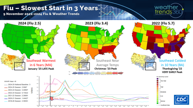
Flu continues to get off to a very slow start, slowest start in 3 years. This is a plus for retail sales with a much healthier population. CLICK ON IMAGES FOR A LARGER VIEW.
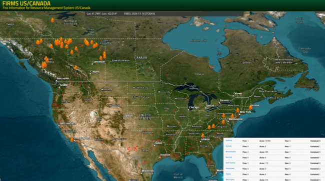
There are several bigger wildfires in Southern California and in the Northeast.
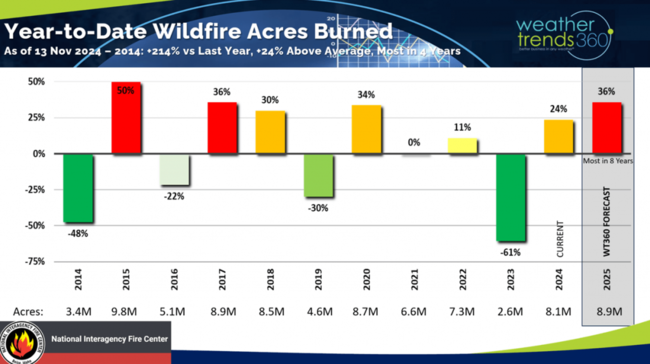
Season-t0-date there have been 8.1 million acres burned, the most in 4 years, +24% above average and +214% above last year. Next year likely to be even more active based on the wt360 year-ahead outlook.
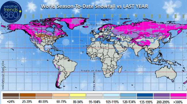
World season-t0-date snowfall shows heavy snow across Siberia, Alaska and Northern Canada.
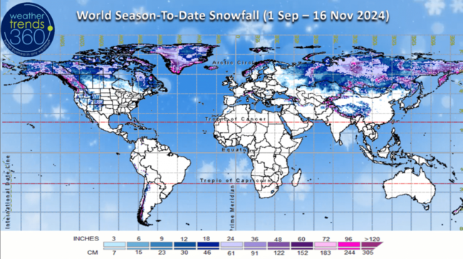
Snowfall is over 300% more than last year for these areas which is one indicator of a colder Winter ahead in North America.
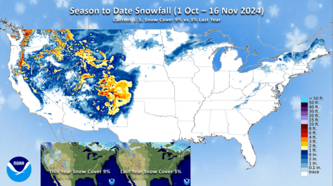
U.S. Season-to-date snowfall shows most of the snow has been in the West so far this Winter. Snow cover this morning stood at 9% of the U.S. vs just 3% this time last year.
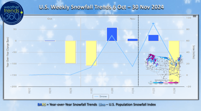
The U.S. weekly snowfall index shows three snowier weeks in a row compared to last year with this coming week bringing the most snow to the U.S. so far this season.
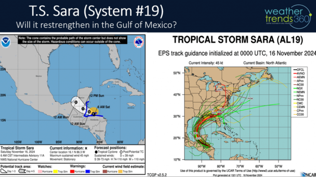
Only two weeks left in the 2024 Hurricane Season, but there is still a threat that Tropical Storm Sara (#18) could impact the U.S. next week.
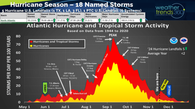
Tropical Storm Sara likely to weaken as it moves over Mexico, but then it could restrengthen as it heads into the Central Gulf of Mexico heading toward the Pan Handle of Florida.
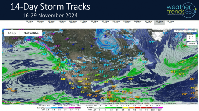
The 14-day storm tracks show several storm systems impacting the U.S. with a more active pattern than the very dry start to Fall. Thanksgiving Day is cooler for many, but nowhere near as cool as last year's coolest conditions in 10 years.
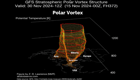
The Polar Vortex shows some weakening with a couple minor intrusions into the U.S. over the next couple weeks. A weaker PV allows cold Arctic air to head South, stronger PV the cold stays bottled up at the North Pole.
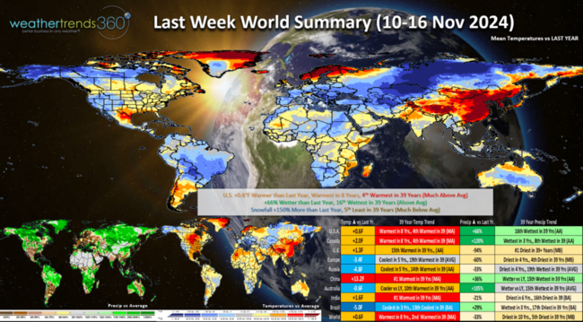
Last week (10-16 Nov) across the World shows the U.S. trending +0.6F warmer than last year, warmest in 8 years and 4th warmest in 39 years. The West was again the most favorable spot for Fall seasonal merchandise sales. Rainfall was up +66% vs last year and 16th wettest of the past 39 years. This has drought going from 88% of the U.S. a couple weeks ago now down to 82% and declining. Snowfall was up +150% over LY, but still 5th least in 39 years. Europe was one of the most favorable areas for Fall merchandise trending coolest in 5 years, while China was the worst trending much hotter than last year and #1 hottest in 39+ years.
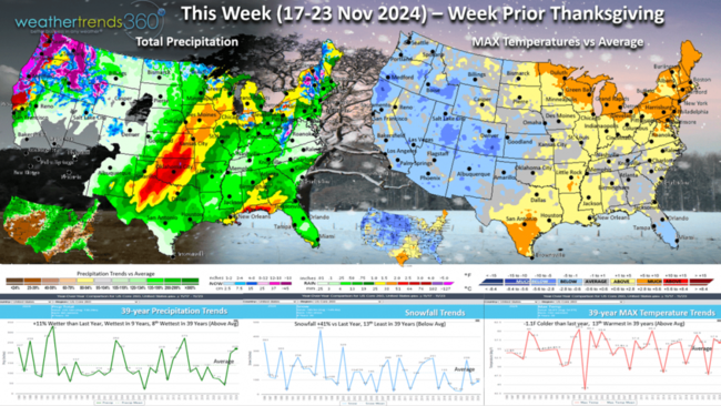
This week (17-23 Nov) prior Thanksgiving shows a strong cold front moving into the Eastern U.S. midweek with much needed rain and snow. This should put out the bigger fire in New England. Temperatures are -1.1F colder than last year and 13th warmest of the past 39 years. Rainfall is again up +11% over LY, most in 9 years and 8th most in 39 years, while snowfall is up +41% vs LY but still 13th least in 39 years. There will be a bigger uptick in seasonal sales later this week with the more wintry conditions moving into the Northeast.
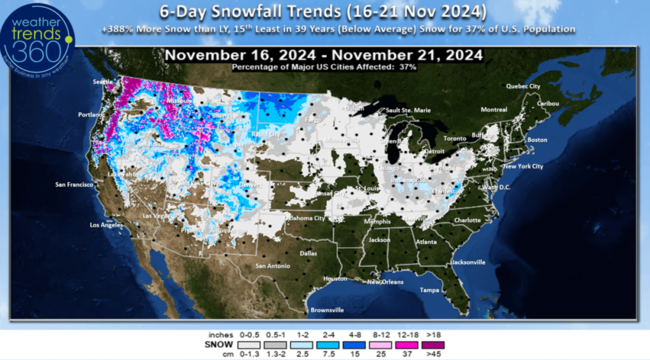
The 6-day snowfall outlook shows some light snow moving into the East. Snowfall up +388% over LY, 15th least in 39 years with 37% of the U.S. getting some snow, the first for many in the Midwest and Ohio Valley.
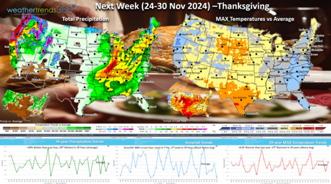
Next week (24-30 Nov) Thanksgiving shows cooler conditions for the East Coast, but this is still much warmer than last year's very cold week. U.S. temperatures trend +6.4F warmer than last year, 13th warmest of the past 39 years. Snowfall down -88% vs last, least in 7 years and 3rd least in 39 years. Rainfall again up +94% vs LY and 20th wettest of the past 39 years.
The World 2-week outlook (17-30 Nov) shows a warming trend across Siberia, continued cool in Europe, Alaska, the Western U.S. and Southeast U.S. Much cooler for China as well.
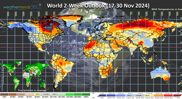
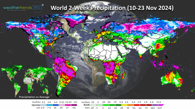
2-Week World rain and snowfall shows a stormier active pattern setting up.
Have a great week ahead and don't forget to follow us on social media for frequent updates: Facebook, Twitter, YouTube, Pinterest and Linkedin.
- Captain Kirk out
Flu continues to get off to a very slow start, slowest start in 3 years. This is a plus for retail sales with a much healthier population. CLICK ON IMAGES FOR A LARGER VIEW.

There are several bigger wildfires in Southern California and in the Northeast.

Season-t0-date there have been 8.1 million acres burned, the most in 4 years, +24% above average and +214% above last year. Next year likely to be even more active based on the wt360 year-ahead outlook.

World season-t0-date snowfall shows heavy snow across Siberia, Alaska and Northern Canada.

Snowfall is over 300% more than last year for these areas which is one indicator of a colder Winter ahead in North America.

U.S. Season-to-date snowfall shows most of the snow has been in the West so far this Winter. Snow cover this morning stood at 9% of the U.S. vs just 3% this time last year.

The U.S. weekly snowfall index shows three snowier weeks in a row compared to last year with this coming week bringing the most snow to the U.S. so far this season.

Only two weeks left in the 2024 Hurricane Season, but there is still a threat that Tropical Storm Sara (#18) could impact the U.S. next week.

Tropical Storm Sara likely to weaken as it moves over Mexico, but then it could restrengthen as it heads into the Central Gulf of Mexico heading toward the Pan Handle of Florida.

The 14-day storm tracks show several storm systems impacting the U.S. with a more active pattern than the very dry start to Fall. Thanksgiving Day is cooler for many, but nowhere near as cool as last year's coolest conditions in 10 years.

The Polar Vortex shows some weakening with a couple minor intrusions into the U.S. over the next couple weeks. A weaker PV allows cold Arctic air to head South, stronger PV the cold stays bottled up at the North Pole.

Last week (10-16 Nov) across the World shows the U.S. trending +0.6F warmer than last year, warmest in 8 years and 4th warmest in 39 years. The West was again the most favorable spot for Fall seasonal merchandise sales. Rainfall was up +66% vs last year and 16th wettest of the past 39 years. This has drought going from 88% of the U.S. a couple weeks ago now down to 82% and declining. Snowfall was up +150% over LY, but still 5th least in 39 years. Europe was one of the most favorable areas for Fall merchandise trending coolest in 5 years, while China was the worst trending much hotter than last year and #1 hottest in 39+ years.

This week (17-23 Nov) prior Thanksgiving shows a strong cold front moving into the Eastern U.S. midweek with much needed rain and snow. This should put out the bigger fire in New England. Temperatures are -1.1F colder than last year and 13th warmest of the past 39 years. Rainfall is again up +11% over LY, most in 9 years and 8th most in 39 years, while snowfall is up +41% vs LY but still 13th least in 39 years. There will be a bigger uptick in seasonal sales later this week with the more wintry conditions moving into the Northeast.

The 6-day snowfall outlook shows some light snow moving into the East. Snowfall up +388% over LY, 15th least in 39 years with 37% of the U.S. getting some snow, the first for many in the Midwest and Ohio Valley.

Next week (24-30 Nov) Thanksgiving shows cooler conditions for the East Coast, but this is still much warmer than last year's very cold week. U.S. temperatures trend +6.4F warmer than last year, 13th warmest of the past 39 years. Snowfall down -88% vs last, least in 7 years and 3rd least in 39 years. Rainfall again up +94% vs LY and 20th wettest of the past 39 years.

The World 2-week outlook (17-30 Nov) shows a warming trend across Siberia, continued cool in Europe, Alaska, the Western U.S. and Southeast U.S. Much cooler for China as well.

2-Week World rain and snowfall shows a stormier active pattern setting up.

Have a great week ahead and don't forget to follow us on social media for frequent updates: Facebook, Twitter, YouTube, Pinterest and Linkedin.
- Captain Kirk out