Captain's Blog 16 Dec '24 Snow Threat Diminishes as Temperatures Moderate
Captain's Log
16 Dec 2024
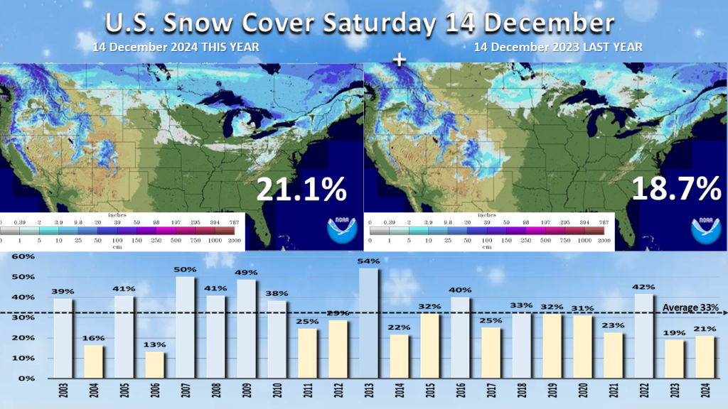
U.S. Snow Cover (14 Dec) shows 21% of the U.S. has snow on the ground vs 19% last year.
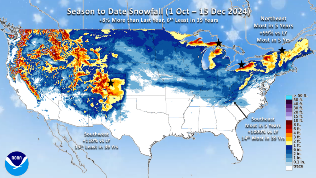
Season-to-date snowfall we're up slightly vs last year but the 6th least in 39 years for the nation as a whole. Some very heavy snow has fallen downwind of the Great Lakes so far this season, and the season-to-date is the snowiest in 5 years for the Northeast.
Last Week (8-14 Dec) across the World shows the U.S. trending -2.5F colder than last year, the coldest in 5 years, but 18th warmest of the past 39 years. Rainfall was +23% vs last year and the 11th wettest in 39 years, while snowfall was up +57% vs last year but the 10th least in 39 years. These were decent trends for seasonal merchandise sales. A bit of unsettled and wintry weather arrived late in the weekend in the Northeast which may have slowed store traffic a tad on Sunday, but the storm was more of a nuisance than a show-stopper (Yet, consumers flocked to the stores to stock up on milk, bread, and eggs!). Saturday, however, was a much drier yet colder day for the region.
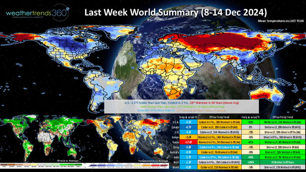
Brazil continued to trend wetter with another week trending the wettest in 39 years. Much colder vs last year across Canada and China, while Russia was very much warmer than last year.
This Week (15-21 Dec) Can you believe it's the last full week before Christmas?! We'll see a moderating trend in the temperature across the nation and this will be the 4th warmest mid-December in 39 years for the U.S. as a whole. However, similar to last week, we'll see the return of colder weather in the latter half of the week across the North Central and Northeastern states.
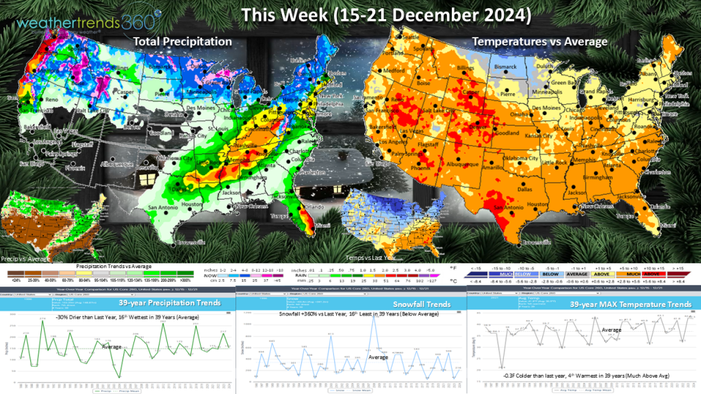
Despite the warmer trends, snowfall is up +360% versus last year but still below average. The week began with a light wintry mix, mainly north and west of the I-95 corridor. Again, mostly just a nuisance storm. Warming temperatures will mean mostly rain for mid-week as the next storm system rolls across the eastern U.S.
Wet in the Pacific Northwest with several storms moving onshore bringing coastal rain but mountain snow.
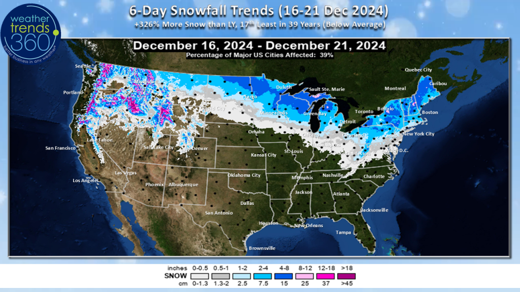
The 6-day (16-22 Dec) snowfall forecast shows +326% more snow than last year but still below average for the United States as a whole. And this may even be a little too optimistic (if you like snow) as models have been backing away from a winter storm in the upcoming weekend; now it looks like just a weak Alberta Clipper spreads light snow mainly across the northern Plains and Great Lakes later this week.
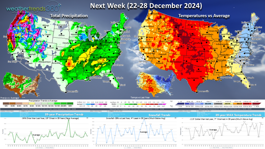
Next week (22-28 Dec) above normal temperatures will continue into the week of Christmas, although the Great Lakes to the East Coast trend colder vs last year. Drier for the country as a whole with the most disruptive weather likely along the West Coast, especially the Northwest where storm systems will continue to move onshore.
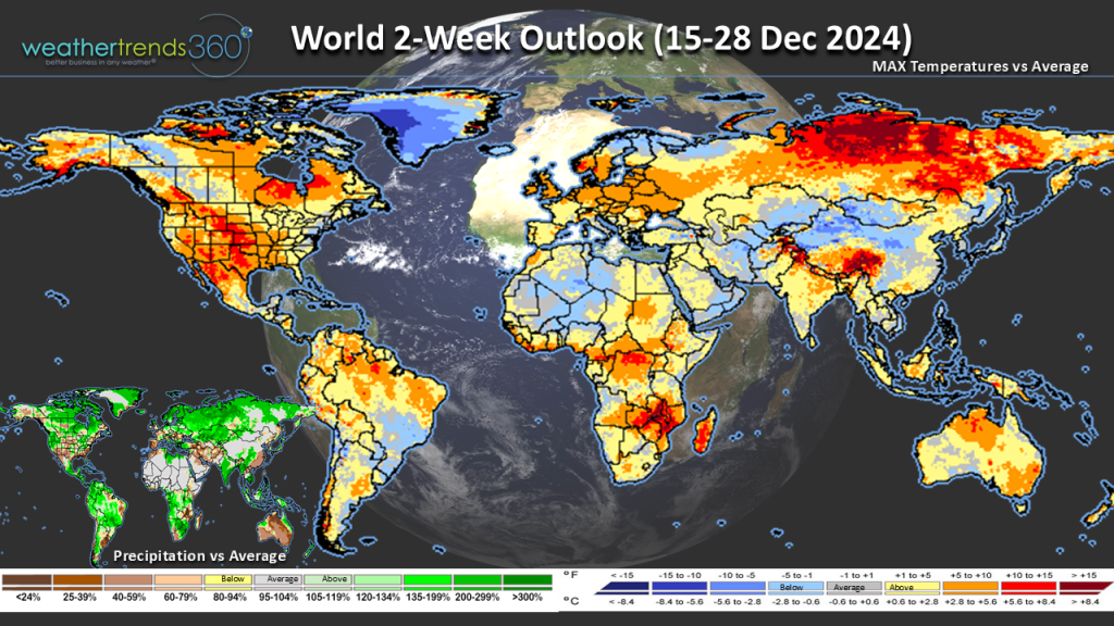
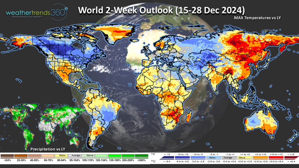
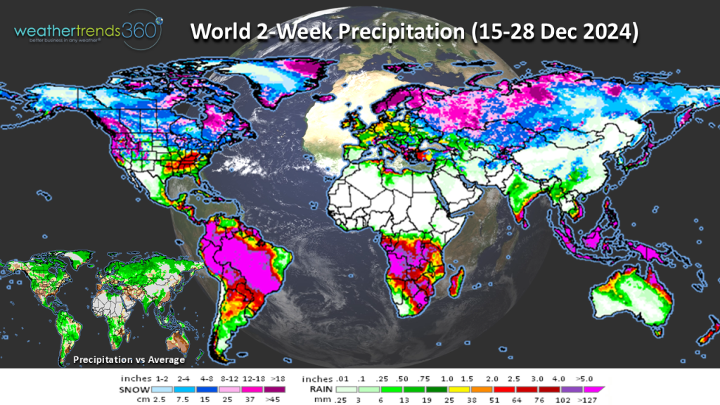
The World 2-week outlook (15-28 Dec) shows that despite the northern U.S. and much of Canada trends colder vs last year, they're largely warmer than normal. Wetter weather appears to continue across Brazil. Drier in the United Kingdom where we'll be comparing to a rather unsettled week of Christmas last year when Storm Gerritt brought flooding and power outages; this year, the weather will be much more favorable for pre-and post-holiday sales.
Have a great week, and don't forget to follow us on social media for frequent updates: Facebook, Twitter, YouTube, Pinterest and Linkedin.
U.S. Snow Cover (14 Dec) shows 21% of the U.S. has snow on the ground vs 19% last year.

Season-to-date snowfall we're up slightly vs last year but the 6th least in 39 years for the nation as a whole. Some very heavy snow has fallen downwind of the Great Lakes so far this season, and the season-to-date is the snowiest in 5 years for the Northeast.

Last Week (8-14 Dec) across the World shows the U.S. trending -2.5F colder than last year, the coldest in 5 years, but 18th warmest of the past 39 years. Rainfall was +23% vs last year and the 11th wettest in 39 years, while snowfall was up +57% vs last year but the 10th least in 39 years. These were decent trends for seasonal merchandise sales. A bit of unsettled and wintry weather arrived late in the weekend in the Northeast which may have slowed store traffic a tad on Sunday, but the storm was more of a nuisance than a show-stopper (Yet, consumers flocked to the stores to stock up on milk, bread, and eggs!). Saturday, however, was a much drier yet colder day for the region.

Brazil continued to trend wetter with another week trending the wettest in 39 years. Much colder vs last year across Canada and China, while Russia was very much warmer than last year.
This Week (15-21 Dec) Can you believe it's the last full week before Christmas?! We'll see a moderating trend in the temperature across the nation and this will be the 4th warmest mid-December in 39 years for the U.S. as a whole. However, similar to last week, we'll see the return of colder weather in the latter half of the week across the North Central and Northeastern states.

Despite the warmer trends, snowfall is up +360% versus last year but still below average. The week began with a light wintry mix, mainly north and west of the I-95 corridor. Again, mostly just a nuisance storm. Warming temperatures will mean mostly rain for mid-week as the next storm system rolls across the eastern U.S.
Wet in the Pacific Northwest with several storms moving onshore bringing coastal rain but mountain snow.
The 6-day (16-22 Dec) snowfall forecast shows +326% more snow than last year but still below average for the United States as a whole. And this may even be a little too optimistic (if you like snow) as models have been backing away from a winter storm in the upcoming weekend; now it looks like just a weak Alberta Clipper spreads light snow mainly across the northern Plains and Great Lakes later this week.

Next week (22-28 Dec) above normal temperatures will continue into the week of Christmas, although the Great Lakes to the East Coast trend colder vs last year. Drier for the country as a whole with the most disruptive weather likely along the West Coast, especially the Northwest where storm systems will continue to move onshore.

The World 2-week outlook (15-28 Dec) shows that despite the northern U.S. and much of Canada trends colder vs last year, they're largely warmer than normal. Wetter weather appears to continue across Brazil. Drier in the United Kingdom where we'll be comparing to a rather unsettled week of Christmas last year when Storm Gerritt brought flooding and power outages; this year, the weather will be much more favorable for pre-and post-holiday sales.


Have a great week, and don't forget to follow us on social media for frequent updates: Facebook, Twitter, YouTube, Pinterest and Linkedin.