Captain's Blog 11 Jan '25 Cold about to become FRIGID!
Captain's Log
11 Jan 25: Let's call it a solemn Saturday in light of the devastation in the West. :(
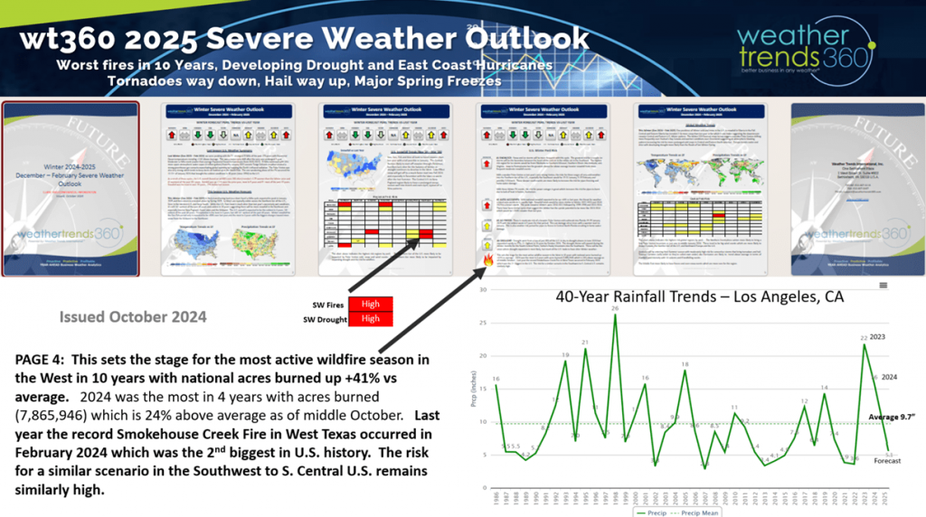
Sadly, the weather setup for these fires was very predictable and predicted in the wt360 severe weather reports issued last fall calling for the worst fire season in 10 years with a very early Winter start - it sadly happened.
 CLICK ON IMAGES FOR A LARGER VIEW
The wt360 year-ahead severe weather reports clearly showed a Santa Ana high fire risk this Winter (very early).
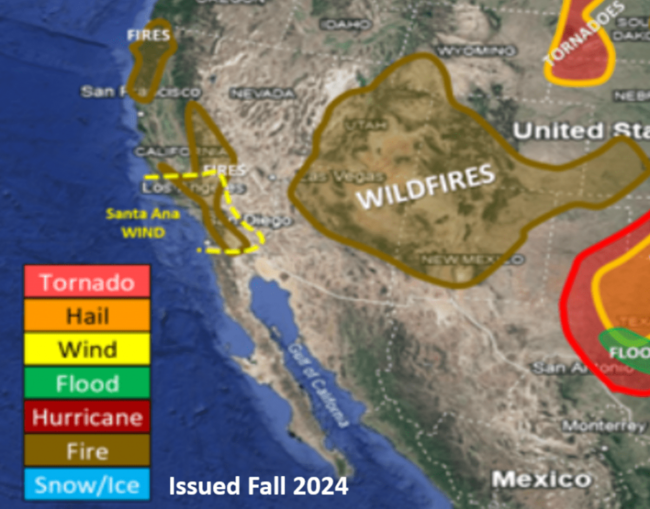
The past two seasons have been very wet in Southern California which allows the brush around the canyons to become very thick. Then as it started to dry out last Summer into this Winter it was fuel waiting for a spark. That spark was a classic Santa Ana wind set up that brings northerly winds down these canyons toward Malibu and Los Angeles.
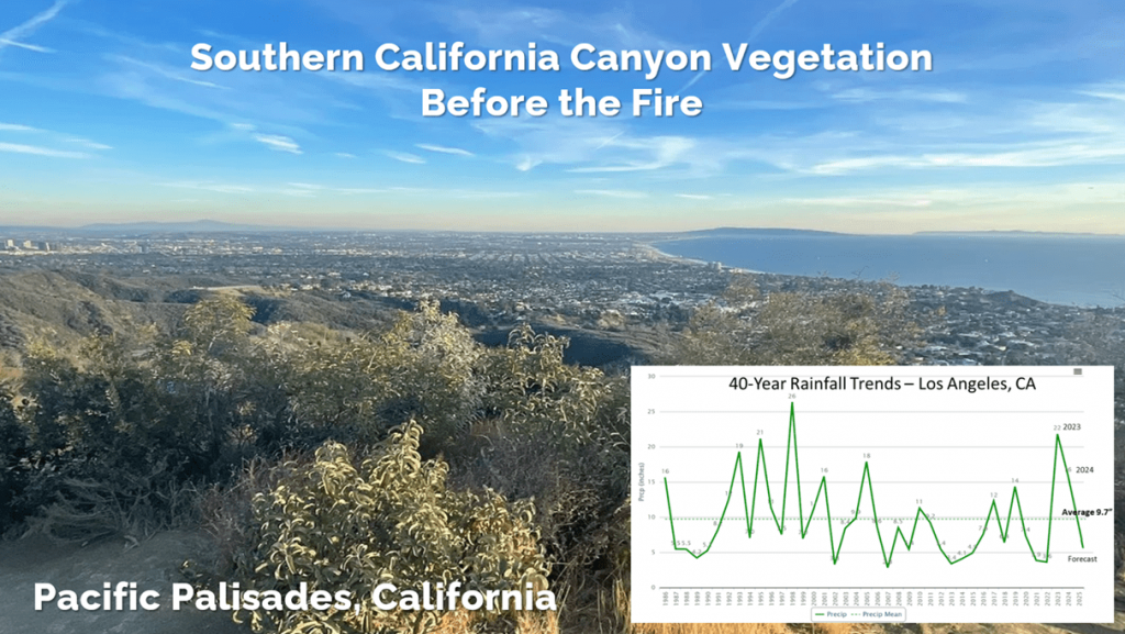
Unfortunately, this is just the start of a very bad fire season in California and other areas of the Southwest.
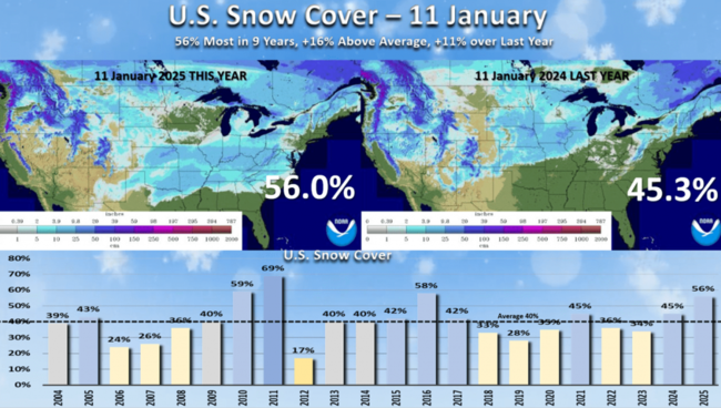
The other big event this week was two snowstorms that traversed the country bringing snow cover this morning to 56% of the U.S. vs 45% last year vs an average of 40%. This is the most snow cover for 11 January in 9 years.
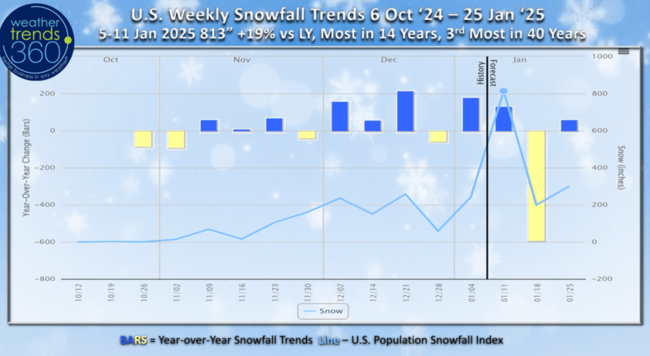
The U.S. weekly snowfall index shows the huge surge in snow for this weekending 11 January that made it the snowiest in 14 years for the U.S. overall, 3rd most in 40 years. Now a bit of a lull as Arctic air invades the Eastern half of the country over the next couple weeks.
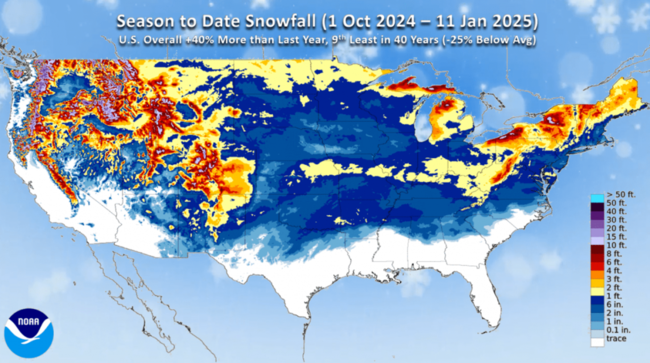
NOAA's season-to-date snowfall shows very widespread snow deep into the southern U.S. Season-to-date snowfall is up +40% over last year but still -25% below average and 9th least of the past 40 years for the U.S. overall.
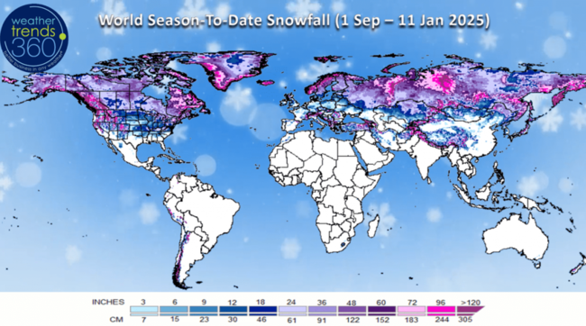
Global season-t0-date snowfall trends show a much snowier Winter for The Eastern U.S., much of Canada and Siberia with over 300% more snow than a year ago.
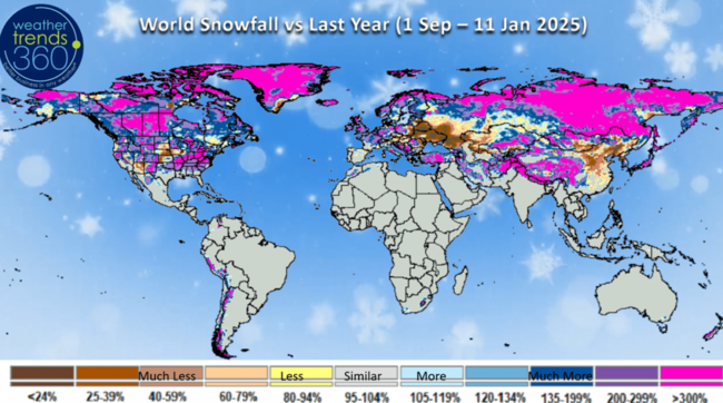
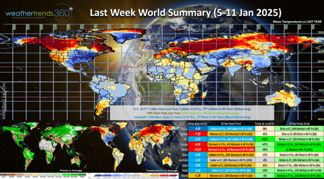
Last week (5-11 Jan) across the World shows the U.S. trending -6.6F colder than last year, coldest in 8 years and 9th coldest of the past 40 years with well below average national temperatures. Snowfall was up +19% vs last year, most in 14 years and 3rd most in 40 years, while rainfall was down -58% vs last year but still 16th wettest of the past 40 years. These are great trends for MUST HAVE WINTER SEASONAL ITEMS, but a bigger negative for store traffic. This is a negative trend for the overall economy that does better in warmer/drier/less snowy weather from January into July.
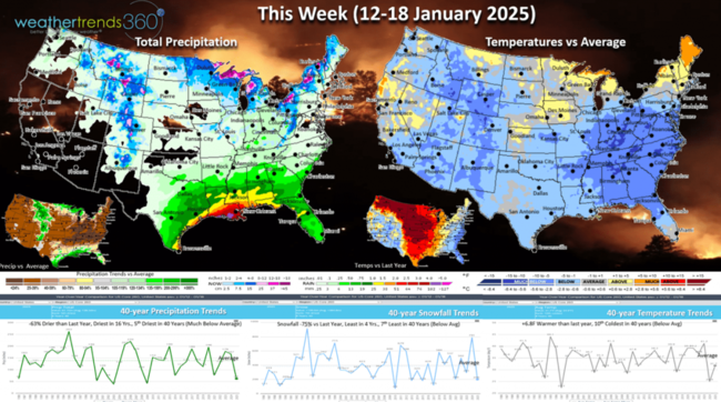
This week (12-18 Jan) is a little misleading as we're up against the big Polar Vortex outbreak last year, so while national temperatures are +6.8F warmer than a year ago, it's still 10th coldest of the past 40 years nationally with well below average national temperatures. Snow takes a break trending down -75% vs last year, least in 4 years and 7th least in 40 years, with rainfall also down -63% vs last year, driest in 16 years and 5th driest of the past 40 years. Sadly, the fire set up for Southern California remains at HIGH RISK with shifting winds and continued very low humidity levels.
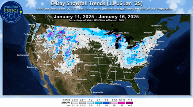
The 6-day snowfall outlook shows the current snowstorm exiting the Middle Atlantic and now a generally less snowy pattern. National snowfall down -67% vs last year, 15th least in 40 years, but 50% of the U.S. getting some light snow.
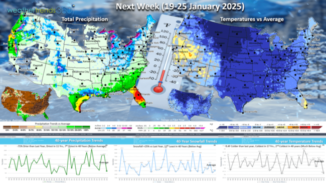
Next week (19-25 Jan) Arctic blast #3 invades much of the country with the coldest air this season. National temperatures trend -9.4F colder than last year, coldest in 17 years and 2nd coldest in 40 years with much below average national temperatures. Snowfall up +25% vs last year but still 12th least in 40 years, while rainfall is again down -71%, dries tin 11 years and 7th driest of the past 40. Need to watch for a Deep South/Gulf Coast snow and ice event from Texas to Louisiana. These are favorable trends for widespread auto battery failures, but a big negative for overall retail store traffic, a common theme for the front half of 2025!
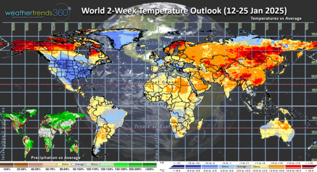
The World 2-week outlook shows the heart of the cold air over the U.S. and Southern Canada.
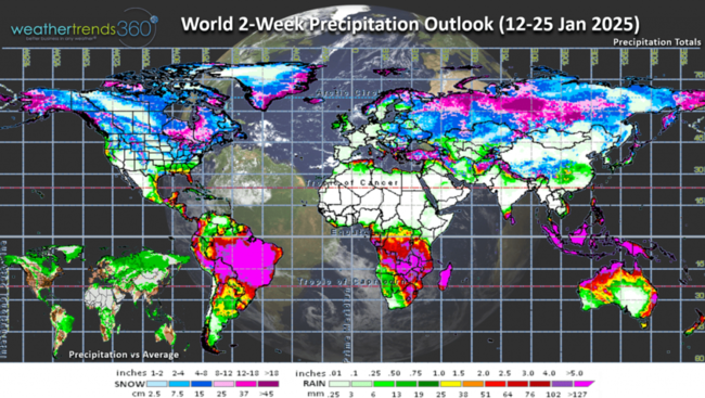
World precipitation shows a generally dry U.S. and very dry Europe while it remains wet in Brazil. Argentina continues to trend very dry.
Have a safe week ahead! Don't forget to follow us on social media for frequent updates:Facebook, Twitter, YouTube, Pinterest and Linkedin.
- Captain Kirk out
Sadly, the weather setup for these fires was very predictable and predicted in the wt360 severe weather reports issued last fall calling for the worst fire season in 10 years with a very early Winter start - it sadly happened.
 CLICK ON IMAGES FOR A LARGER VIEW
The wt360 year-ahead severe weather reports clearly showed a Santa Ana high fire risk this Winter (very early).

The past two seasons have been very wet in Southern California which allows the brush around the canyons to become very thick. Then as it started to dry out last Summer into this Winter it was fuel waiting for a spark. That spark was a classic Santa Ana wind set up that brings northerly winds down these canyons toward Malibu and Los Angeles.

Unfortunately, this is just the start of a very bad fire season in California and other areas of the Southwest.

The other big event this week was two snowstorms that traversed the country bringing snow cover this morning to 56% of the U.S. vs 45% last year vs an average of 40%. This is the most snow cover for 11 January in 9 years.

The U.S. weekly snowfall index shows the huge surge in snow for this weekending 11 January that made it the snowiest in 14 years for the U.S. overall, 3rd most in 40 years. Now a bit of a lull as Arctic air invades the Eastern half of the country over the next couple weeks.

NOAA's season-to-date snowfall shows very widespread snow deep into the southern U.S. Season-to-date snowfall is up +40% over last year but still -25% below average and 9th least of the past 40 years for the U.S. overall.

Global season-t0-date snowfall trends show a much snowier Winter for The Eastern U.S., much of Canada and Siberia with over 300% more snow than a year ago.

Last week (5-11 Jan) across the World shows the U.S. trending -6.6F colder than last year, coldest in 8 years and 9th coldest of the past 40 years with well below average national temperatures. Snowfall was up +19% vs last year, most in 14 years and 3rd most in 40 years, while rainfall was down -58% vs last year but still 16th wettest of the past 40 years. These are great trends for MUST HAVE WINTER SEASONAL ITEMS, but a bigger negative for store traffic. This is a negative trend for the overall economy that does better in warmer/drier/less snowy weather from January into July.

This week (12-18 Jan) is a little misleading as we're up against the big Polar Vortex outbreak last year, so while national temperatures are +6.8F warmer than a year ago, it's still 10th coldest of the past 40 years nationally with well below average national temperatures. Snow takes a break trending down -75% vs last year, least in 4 years and 7th least in 40 years, with rainfall also down -63% vs last year, driest in 16 years and 5th driest of the past 40 years. Sadly, the fire set up for Southern California remains at HIGH RISK with shifting winds and continued very low humidity levels.

The 6-day snowfall outlook shows the current snowstorm exiting the Middle Atlantic and now a generally less snowy pattern. National snowfall down -67% vs last year, 15th least in 40 years, but 50% of the U.S. getting some light snow.

Next week (19-25 Jan) Arctic blast #3 invades much of the country with the coldest air this season. National temperatures trend -9.4F colder than last year, coldest in 17 years and 2nd coldest in 40 years with much below average national temperatures. Snowfall up +25% vs last year but still 12th least in 40 years, while rainfall is again down -71%, dries tin 11 years and 7th driest of the past 40. Need to watch for a Deep South/Gulf Coast snow and ice event from Texas to Louisiana. These are favorable trends for widespread auto battery failures, but a big negative for overall retail store traffic, a common theme for the front half of 2025!

The World 2-week outlook shows the heart of the cold air over the U.S. and Southern Canada.

World precipitation shows a generally dry U.S. and very dry Europe while it remains wet in Brazil. Argentina continues to trend very dry.

Have a safe week ahead! Don't forget to follow us on social media for frequent updates:Facebook, Twitter, YouTube, Pinterest and Linkedin.
- Captain Kirk out