Captain's Blog 1 Mar '25 Up & Down Spring Pattern
Captain's Log
1 March '25: Happy 1st day of Meteorological Spring! :)
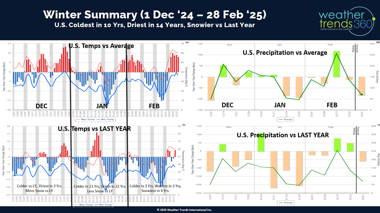
Winter (1 Dec - 28 Feb) is officially in the history books with the coldest Winter in 10 years, driest in 14 years and +38% more snow than last year. CLICK ON IMAGES FOR A LARGER VIEW.
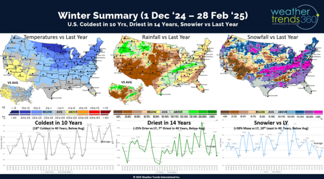
A day-by-day national view shows there were 7 much colder periods than last Winter which benefited Winter seasonal categories. Recall last year really only had the one big mid-January Polar Vortex that led to a huge spike in seasonal sales, so the more frequent cold was a bigger plus this season.

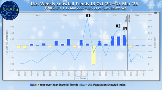
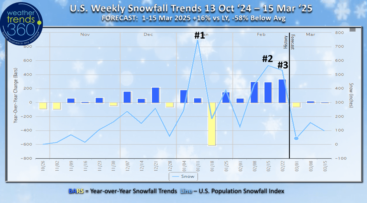
There were also 10 snowier weeks nationally vs last year Winter with the #1 snowiest week 5-11 January, #2 was 9-15 February and #3 15-22 February.
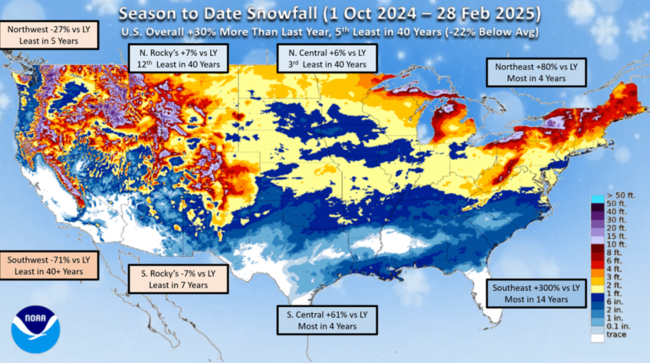
Season-to-date snowfall shows the Southwest was the biggest loser, trending least in over 40 years and -71% less snow than last year. The winners were in the Southeast where it was the snowiest in 14 years. The Northeast had the most snow in 4 years, but the coastal regions were again well below average.
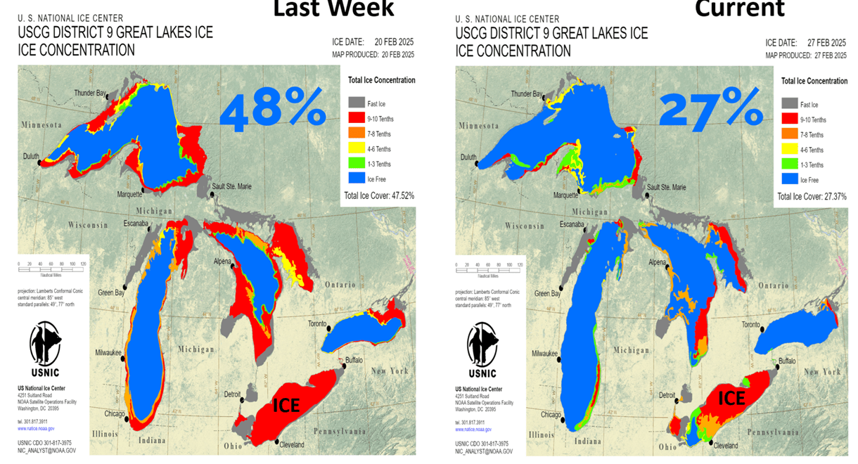
With the big February Thaw at the end of the month, Great Lakes ice cover went from 48% coverage down to 27%. The lake are still cold and much more coverage than last year, so this will help to keep the Northeast on the cooler side this Spring.

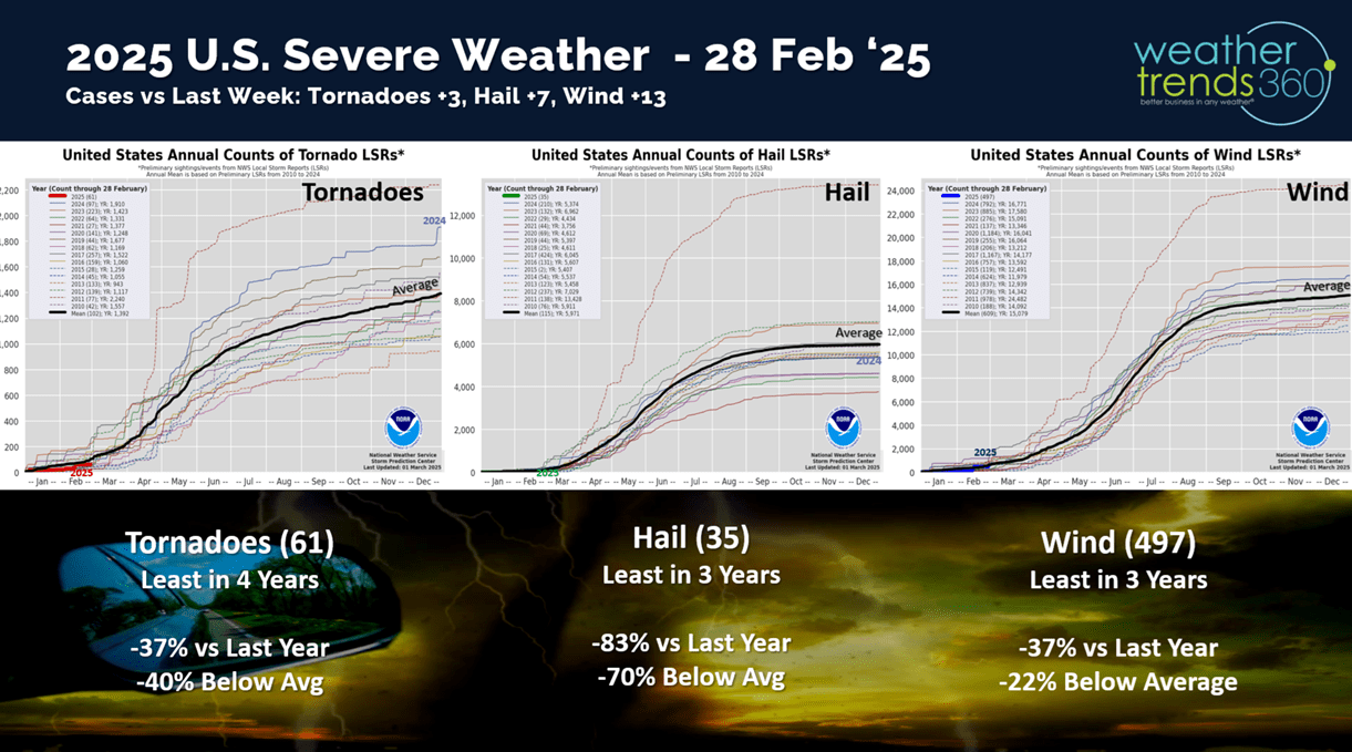
Severe weather to date is down in all three categories with tornadoes down -37% vs last year, least in 4 years, hail cases down -83% least in 3 years and now wind cases are down -37% vs last year and least in 3 years. Severe weather season starts in March, but we're expecting a much less active season than last year's near record year.

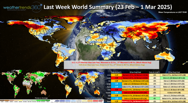
Last week (23 Feb - 1 Mar) across the World shows the U.S. trending +1.1F warmer than last year, warmest in 25 years and 2nd warmest in 40 years. A wholesale change from the coldest middle February period in over 40 years. Rainfall was down -52% vs last year and driest in 37 years while snowfall was down -63% and #1 least in 40 years. These were generally favorable trends for store traffic. But consumer discretionary spending is being hard hit by utility bills some +25% to +55% higher than last year. This will negatively impact March consumer spending. The significantly cold spot was in far Eastern Europe, a negative for Spring seasonal sales.
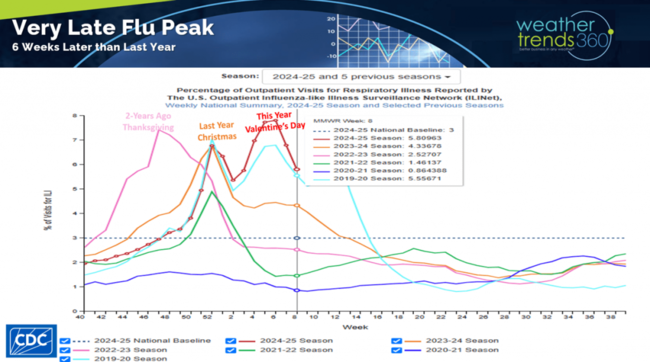
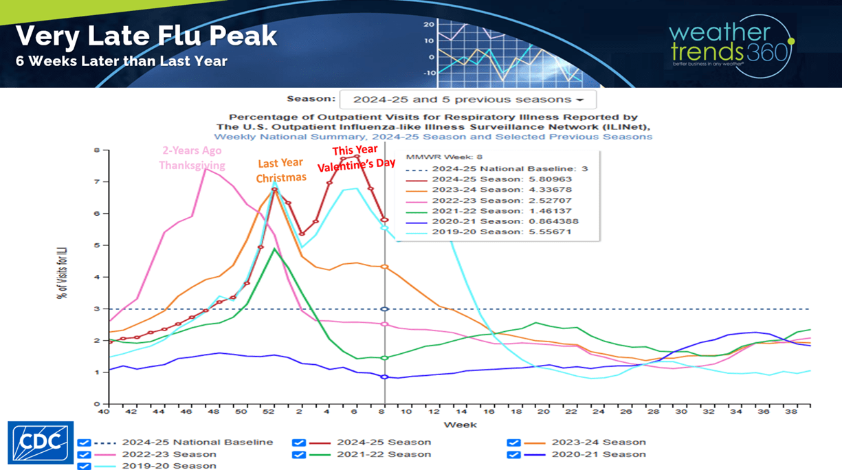
Flu has started its Spring decline after a huge spike in middle February. This was a 6-week later peak than last year. The very warm Fall delayed the season and then very cold Winter weather allowed for widespread surge in activity.
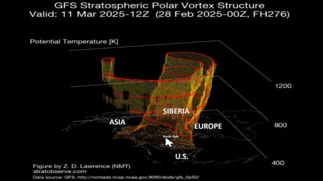
Winter may not be over just yet as the Polar Vortex starts its typical Spring collapsing phase. As it weakens, it can allow colder air to surge south and some hint of that on the 14-day outlook with a tongue headed for Eastern North America.
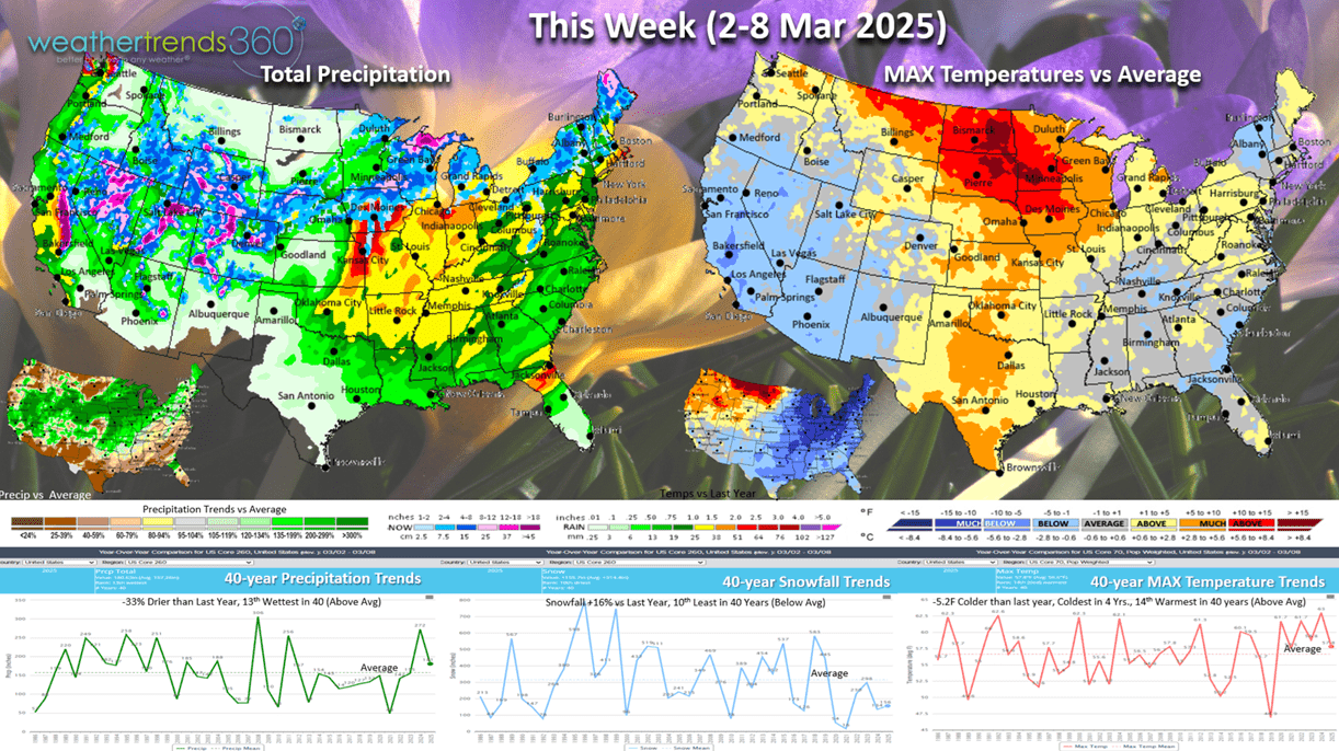
This Week (2-8 March) trends -5.2F colder than last year, coldest in 4 years but 14th warmest of the past 40 years nationally. The Central and Eastern U.S. trend much colder than a year ago. While snowfall is up +16% vs last year, it's still 10th least of the past 40 years. The west turns wintrier with a system moving through the Midwest with some moderate snow. Rainfall down -33% vs last year but still 13th wettest of the past 40 years. These are more negative trends for early Spring seasonal merchandise.

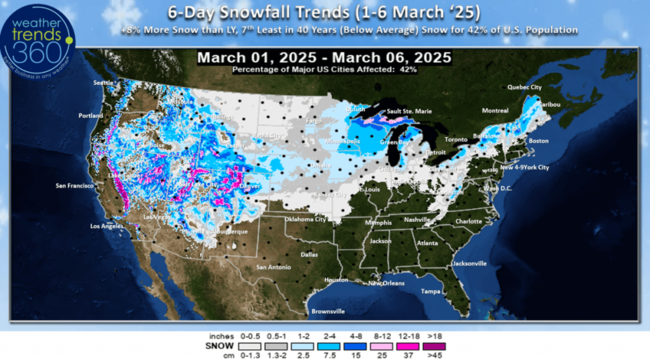
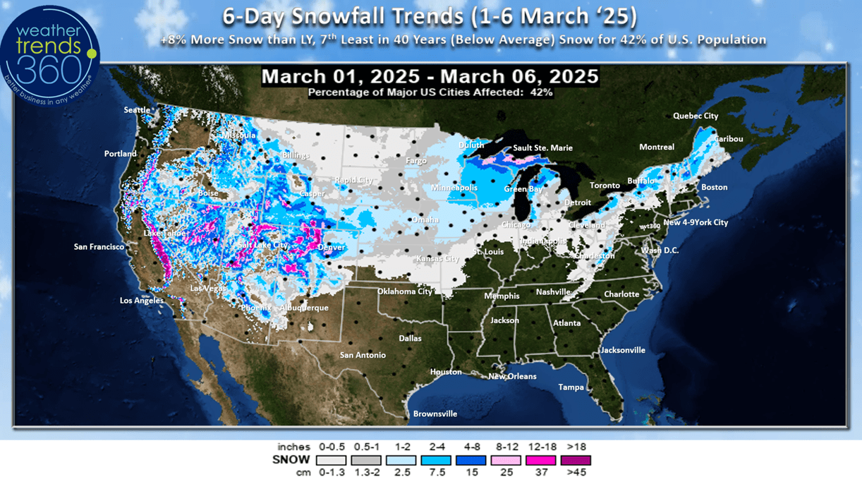
The 6-day snowfall outlook (1-6 March) shows a 1-4" type snow event moving from Nebraska into Wisconsin with some Lake Effect snow in the Northeast. The West is the bigger winner with heavy mountain snow. Overall national snowfall is up +8% with 42% of U.S. getting some snow.
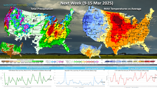
Next week (9-15 March) trend -1.1F colder than last year but 8th warmest of the past 40 years. snowfall up +7% and rainfall up +31% and the most in 9 years. Winter West, Spring Central while the Northeast is still colder than last year. These are generally unfavorable trends for Spring merchandise sales, but the cold in the West will help to clear out some excess Winter merchandise.
Don't forget to Spring ahead on Sunday 8 March as Daylight Saving Time starts at 2am.

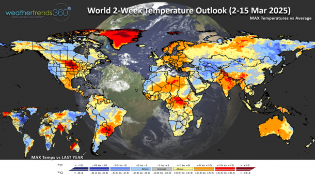
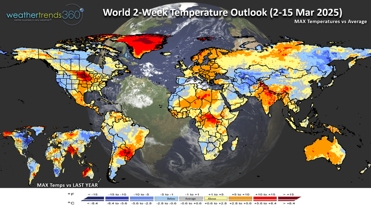
The World 2-week outlook (2-15 March) shows Winter moves into the Western U.S. while the Central states getting a taste of Spring. Despite the warmer weather, it's still much colder in the Eastern half of North America than last year.
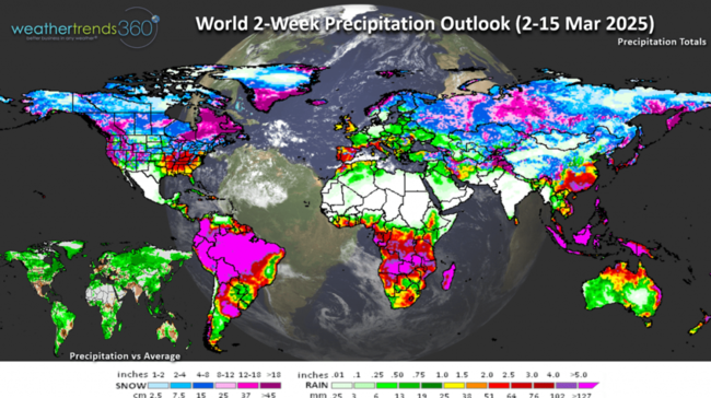
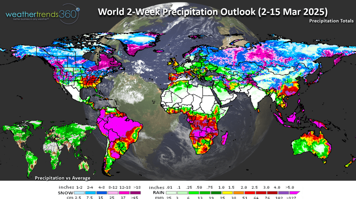
World 2-week Precipitation (2-15 March) shows a stormy pattern setting up for the U.S.
We hope you have a great week ahead, and don't forget to follow us on social media for frequent updates: Facebook, Twitter, YouTube, Pinterest and Linkedin.
- Captain Kirk out
Winter (1 Dec - 28 Feb) is officially in the history books with the coldest Winter in 10 years, driest in 14 years and +38% more snow than last year. CLICK ON IMAGES FOR A LARGER VIEW.

A day-by-day national view shows there were 7 much colder periods than last Winter which benefited Winter seasonal categories. Recall last year really only had the one big mid-January Polar Vortex that led to a huge spike in seasonal sales, so the more frequent cold was a bigger plus this season.
There were also 10 snowier weeks nationally vs last year Winter with the #1 snowiest week 5-11 January, #2 was 9-15 February and #3 15-22 February.
Season-to-date snowfall shows the Southwest was the biggest loser, trending least in over 40 years and -71% less snow than last year. The winners were in the Southeast where it was the snowiest in 14 years. The Northeast had the most snow in 4 years, but the coastal regions were again well below average.

With the big February Thaw at the end of the month, Great Lakes ice cover went from 48% coverage down to 27%. The lake are still cold and much more coverage than last year, so this will help to keep the Northeast on the cooler side this Spring.
Severe weather to date is down in all three categories with tornadoes down -37% vs last year, least in 4 years, hail cases down -83% least in 3 years and now wind cases are down -37% vs last year and least in 3 years. Severe weather season starts in March, but we're expecting a much less active season than last year's near record year.
Last week (23 Feb - 1 Mar) across the World shows the U.S. trending +1.1F warmer than last year, warmest in 25 years and 2nd warmest in 40 years. A wholesale change from the coldest middle February period in over 40 years. Rainfall was down -52% vs last year and driest in 37 years while snowfall was down -63% and #1 least in 40 years. These were generally favorable trends for store traffic. But consumer discretionary spending is being hard hit by utility bills some +25% to +55% higher than last year. This will negatively impact March consumer spending. The significantly cold spot was in far Eastern Europe, a negative for Spring seasonal sales.

Flu has started its Spring decline after a huge spike in middle February. This was a 6-week later peak than last year. The very warm Fall delayed the season and then very cold Winter weather allowed for widespread surge in activity.
Winter may not be over just yet as the Polar Vortex starts its typical Spring collapsing phase. As it weakens, it can allow colder air to surge south and some hint of that on the 14-day outlook with a tongue headed for Eastern North America.

This Week (2-8 March) trends -5.2F colder than last year, coldest in 4 years but 14th warmest of the past 40 years nationally. The Central and Eastern U.S. trend much colder than a year ago. While snowfall is up +16% vs last year, it's still 10th least of the past 40 years. The west turns wintrier with a system moving through the Midwest with some moderate snow. Rainfall down -33% vs last year but still 13th wettest of the past 40 years. These are more negative trends for early Spring seasonal merchandise.
The 6-day snowfall outlook (1-6 March) shows a 1-4" type snow event moving from Nebraska into Wisconsin with some Lake Effect snow in the Northeast. The West is the bigger winner with heavy mountain snow. Overall national snowfall is up +8% with 42% of U.S. getting some snow.
Next week (9-15 March) trend -1.1F colder than last year but 8th warmest of the past 40 years. snowfall up +7% and rainfall up +31% and the most in 9 years. Winter West, Spring Central while the Northeast is still colder than last year. These are generally unfavorable trends for Spring merchandise sales, but the cold in the West will help to clear out some excess Winter merchandise.

Don't forget to Spring ahead on Sunday 8 March as Daylight Saving Time starts at 2am.

The World 2-week outlook (2-15 March) shows Winter moves into the Western U.S. while the Central states getting a taste of Spring. Despite the warmer weather, it's still much colder in the Eastern half of North America than last year.
World 2-week Precipitation (2-15 March) shows a stormy pattern setting up for the U.S.
We hope you have a great week ahead, and don't forget to follow us on social media for frequent updates: Facebook, Twitter, YouTube, Pinterest and Linkedin.
- Captain Kirk out