Captain's Blog 1 Feb '25 Stormier Pattern Ahead
Captain's Log
1 Feb '25: Happy Saturday :)
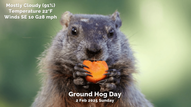
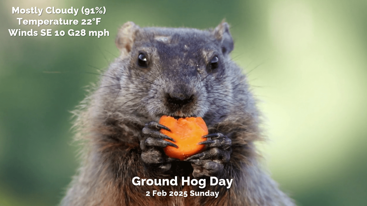
Hard to believe we're 69% done with Winter with Groundhog Day tomorrow. Punxsutawney Phil MIGHT see his shadow with a break in the clouds...TBD. Sees his shadow...6 more weeks of Winter which we agree with! CLICK ON IMAGES FOR A LARGER VIEW.
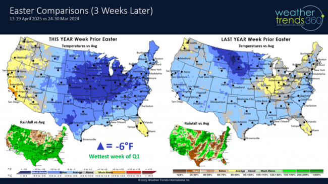
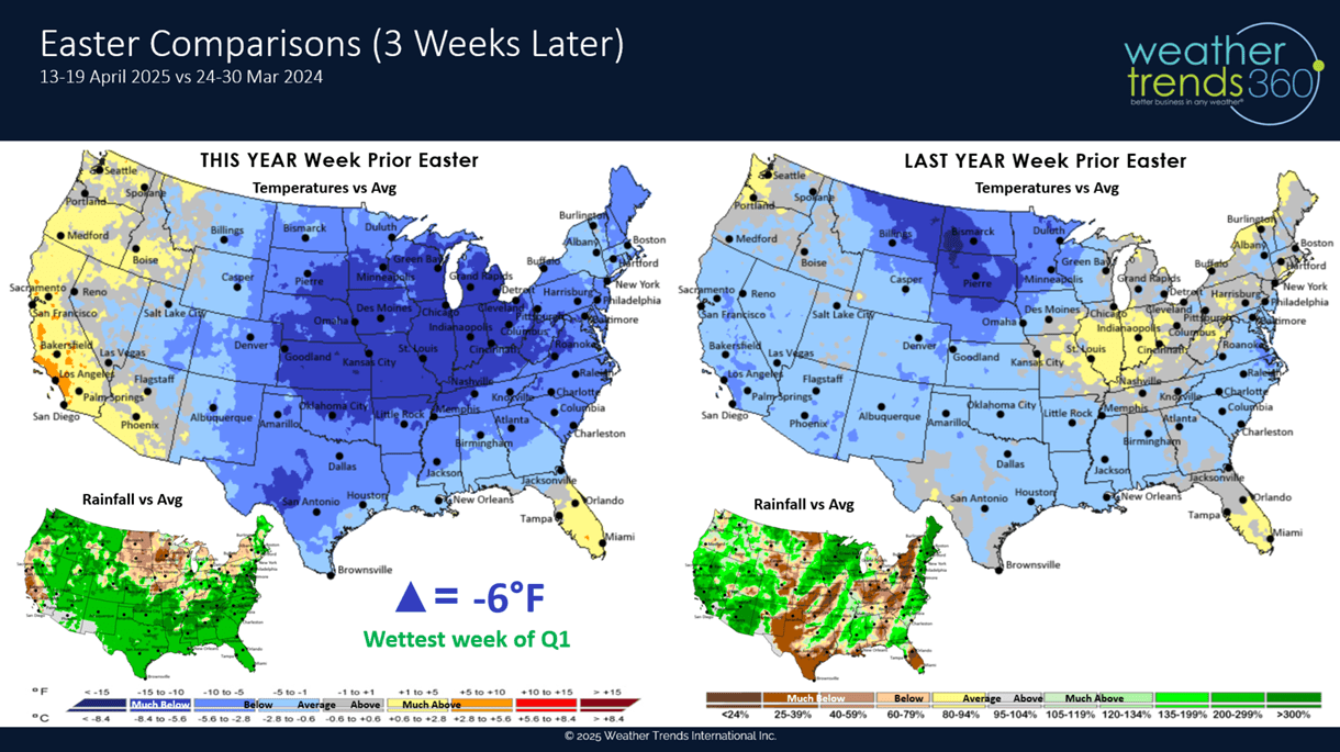
We don't really care what the groundhog says as we have a much colder Spring ahead well into May! Easter week shifts 3 weeks later this year, but it shifts in what appears to be a cold and wet unfavorable week. It will be a very challenging Q1 ahead.
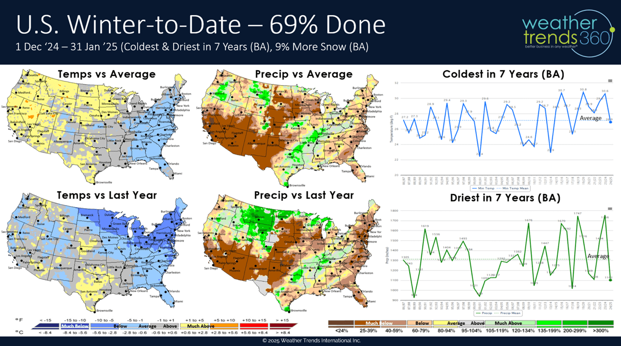
With Winter (1 Dec - 28 Feb) 69% done, a recap so far shows the U.S. overall trending the coldest in 7 years with slightly below average national temperatures, especially in the East. Rainfall is also the least in 7 years and below average while snowfall is up a bit over last year.

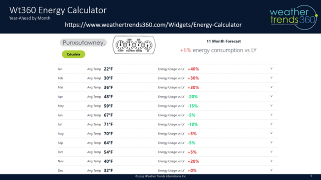
January was the coldest in 11 years nationally which will put a big dent in consumer's discretionary spending with much higher heating bills. The Northeast is the hardest hit with energy consumption up at least 33% over last year.

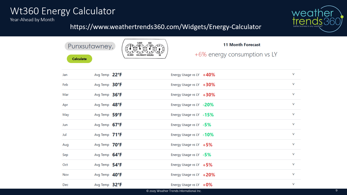
The wt360 Year-Ahead Energy Widget will calculate the expected changes in your consumption month-by-month anywhere on Earth.
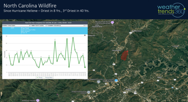
wt360 had forecast very dry conditions to develop in the Southeast after the catastrophic flooding of Hurricane Helene setting the stage for wildfires as indicated in our year-ahead severe weather insurance reports. That's happened and we already have a big fire to the Northeast of Asheville, NC. This will be a theme this Spring.
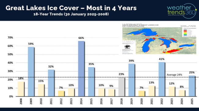
With the cold January, the Great Lakes have added a lot of ice with 25% of the lakes covered. Lake Erie is almost completely covered in ice which helps to shut down the Lake Effect snow machine. Ice cover is the most in 4 years and way up over last year's 8% coverage.
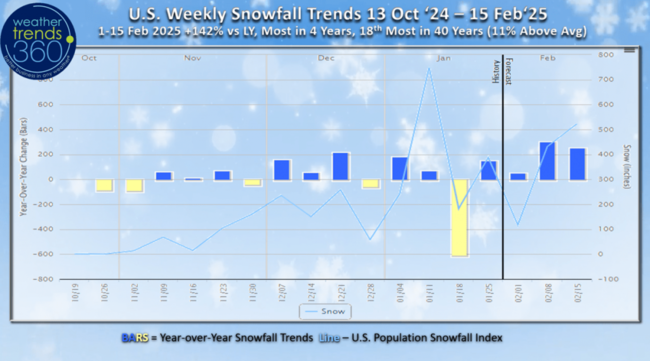
U.S. snowfall trends show the next two weeks trending +142% snowier than last year, most in 4 years, 18th most in 40 years and 11% above average. The potential for the 2nd snowiest week of Winter likely.
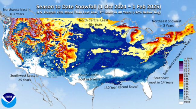
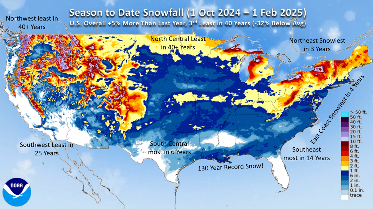
Season-to-date snowfall across the U.S. shows the Northwest and North Central having the least in 40 years, least in 25 years in the Southwest while the Southeast is the most in 14 years. U.S. overall trending +5% more than last year but still -32% below average.
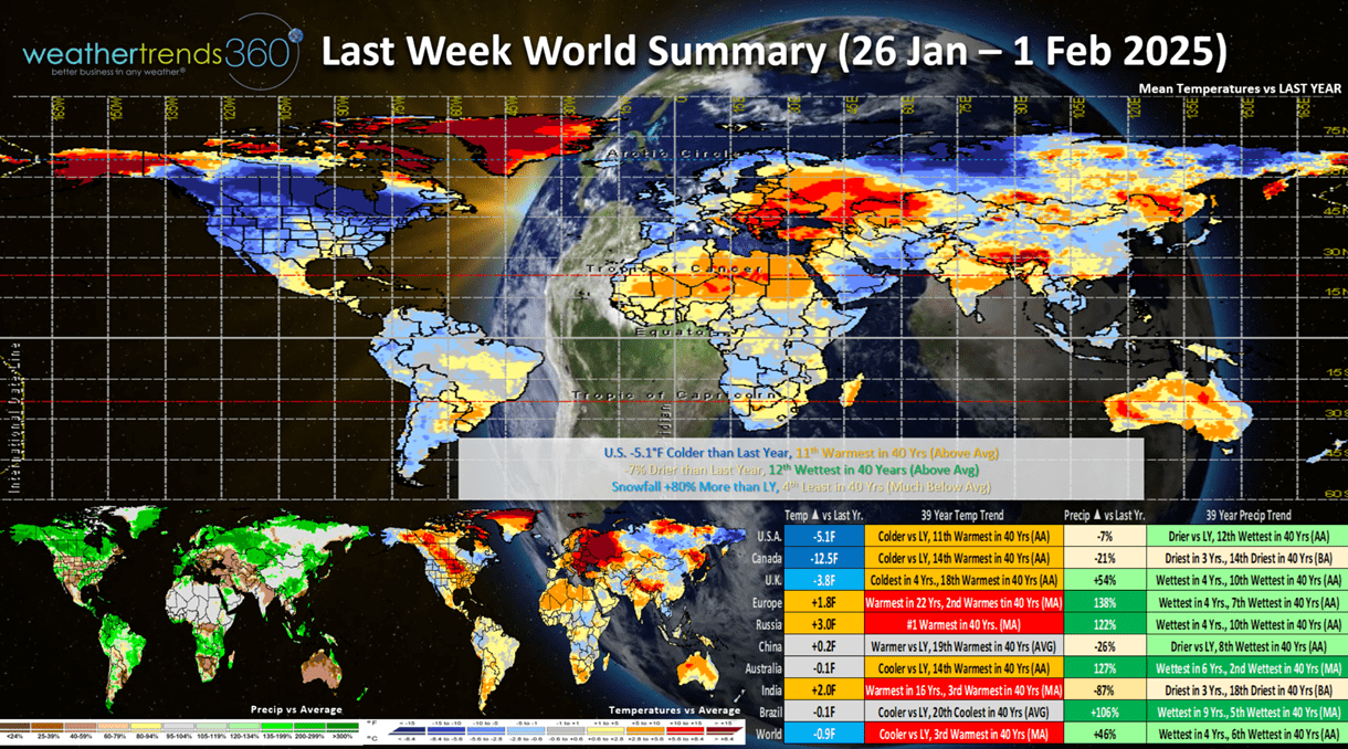
Last Week (26 Jan - 1 Feb) across the World shows the U.S. trending -5.1F colder than last year and 11th warmest of the past 40 years. Rainfall was down -7% vs LY but still 12th wettest of the past 40 years while snowfall was up +80% but still 4th least in 40 years. This was a moderately favorable week for Winter clearance sales. Canada was much colder than last year while Europe was the warmest in 22 years.

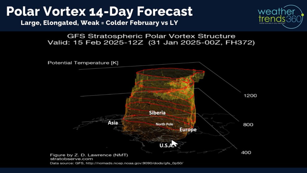
The Polar Vortex continues to show the potential for a weakening phase as it becomes elongated. This increases the risk for another Polar outbreak, most likely the latter half of February into March.
 This week (2-8 Feb) shows Winter finally impacting the Northwest with some colder and snowier weather while the South gets a taste of Spring after all the recent cold and snow. The U.S. overall trends -0.4F colder than last year but still 4th warmest of the past 40 years. Snowfall up +232% over last year, the most in 3 years and 19th most of the past 40 years with above average snowfall. Rainfall up +8%, most in 3 years and 19th wettest in 40 years. The pattern definitely looks to get stormier here in February bringing disruptions to store traffic.

The 6-day snowfall outlook show storms traversing the Northern tier of the U.S. with the Northwest the big winner.
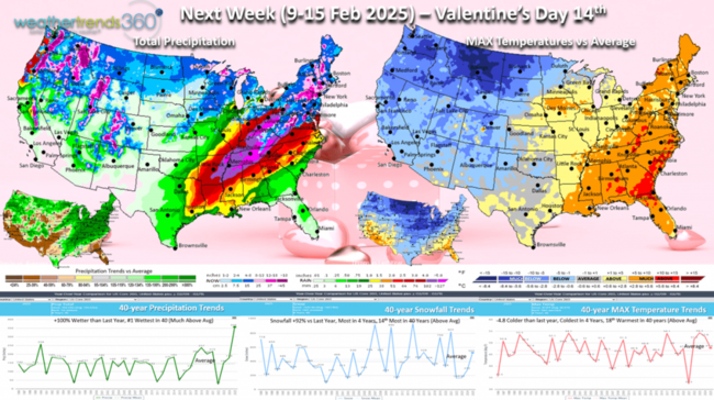
Next week (9-15 Feb - Valentine's Day 14th) shows signs of the Polar Vortex trying to bring in some colder weather for the Western half of the U.S. The country overall trends -4.8F colder than last year, coldest in 4 years and 18th warmest of the past 40 years. Snowfall up +92%, most in 4 years and 14th most of the past 40 years with the potential for a bigger storm in the Northeast. Rainfall looks to be way up +100% and the #1 most in 40+ years. This is a net negative for store traffic due to the inclement weather. Warmer/Drier weather now until August is typically more favorable for overall store traffic and retail sales.
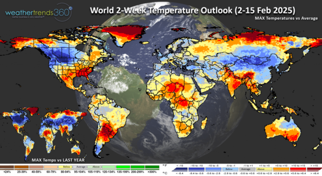
The World 2-week outlook (2-15 Feb) shows Western North America having a stronger week for Winter merchandise while the Southeast gets a reprieve.
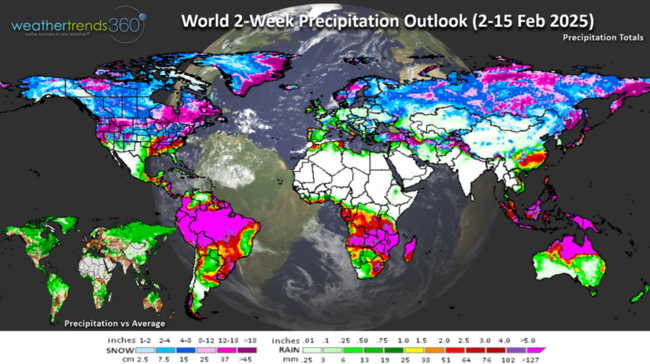
World Precipitation trends show a stormy pattern across the U.S. but generally very dry across Europe.
We hope you have a great week ahead, and don't forget to follow us on social media for frequent updates: Facebook, Twitter, YouTube, Pinterest and Linkedin.
- Captain Kirk out
Hard to believe we're 69% done with Winter with Groundhog Day tomorrow. Punxsutawney Phil MIGHT see his shadow with a break in the clouds...TBD. Sees his shadow...6 more weeks of Winter which we agree with! CLICK ON IMAGES FOR A LARGER VIEW.
We don't really care what the groundhog says as we have a much colder Spring ahead well into May! Easter week shifts 3 weeks later this year, but it shifts in what appears to be a cold and wet unfavorable week. It will be a very challenging Q1 ahead.
With Winter (1 Dec - 28 Feb) 69% done, a recap so far shows the U.S. overall trending the coldest in 7 years with slightly below average national temperatures, especially in the East. Rainfall is also the least in 7 years and below average while snowfall is up a bit over last year.
January was the coldest in 11 years nationally which will put a big dent in consumer's discretionary spending with much higher heating bills. The Northeast is the hardest hit with energy consumption up at least 33% over last year.

The wt360 Year-Ahead Energy Widget will calculate the expected changes in your consumption month-by-month anywhere on Earth.
wt360 had forecast very dry conditions to develop in the Southeast after the catastrophic flooding of Hurricane Helene setting the stage for wildfires as indicated in our year-ahead severe weather insurance reports. That's happened and we already have a big fire to the Northeast of Asheville, NC. This will be a theme this Spring.

With the cold January, the Great Lakes have added a lot of ice with 25% of the lakes covered. Lake Erie is almost completely covered in ice which helps to shut down the Lake Effect snow machine. Ice cover is the most in 4 years and way up over last year's 8% coverage.

U.S. snowfall trends show the next two weeks trending +142% snowier than last year, most in 4 years, 18th most in 40 years and 11% above average. The potential for the 2nd snowiest week of Winter likely.

Season-to-date snowfall across the U.S. shows the Northwest and North Central having the least in 40 years, least in 25 years in the Southwest while the Southeast is the most in 14 years. U.S. overall trending +5% more than last year but still -32% below average.
Last Week (26 Jan - 1 Feb) across the World shows the U.S. trending -5.1F colder than last year and 11th warmest of the past 40 years. Rainfall was down -7% vs LY but still 12th wettest of the past 40 years while snowfall was up +80% but still 4th least in 40 years. This was a moderately favorable week for Winter clearance sales. Canada was much colder than last year while Europe was the warmest in 22 years.
The Polar Vortex continues to show the potential for a weakening phase as it becomes elongated. This increases the risk for another Polar outbreak, most likely the latter half of February into March.
This week (2-8 Feb) shows Winter finally impacting the Northwest with some colder and snowier weather while the South gets a taste of Spring after all the recent cold and snow. The U.S. overall trends -0.4F colder than last year but still 4th warmest of the past 40 years. Snowfall up +232% over last year, the most in 3 years and 19th most of the past 40 years with above average snowfall. Rainfall up +8%, most in 3 years and 19th wettest in 40 years. The pattern definitely looks to get stormier here in February bringing disruptions to store traffic.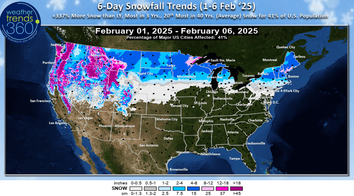
The 6-day snowfall outlook show storms traversing the Northern tier of the U.S. with the Northwest the big winner.

Next week (9-15 Feb - Valentine's Day 14th) shows signs of the Polar Vortex trying to bring in some colder weather for the Western half of the U.S. The country overall trends -4.8F colder than last year, coldest in 4 years and 18th warmest of the past 40 years. Snowfall up +92%, most in 4 years and 14th most of the past 40 years with the potential for a bigger storm in the Northeast. Rainfall looks to be way up +100% and the #1 most in 40+ years. This is a net negative for store traffic due to the inclement weather. Warmer/Drier weather now until August is typically more favorable for overall store traffic and retail sales.
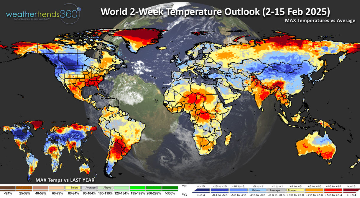
The World 2-week outlook (2-15 Feb) shows Western North America having a stronger week for Winter merchandise while the Southeast gets a reprieve.

World Precipitation trends show a stormy pattern across the U.S. but generally very dry across Europe.
We hope you have a great week ahead, and don't forget to follow us on social media for frequent updates: Facebook, Twitter, YouTube, Pinterest and Linkedin.
- Captain Kirk out