7 Mar '26 Weather Brief: Brief Warm up East, then Polar Vortex Returns
Captain's Log
7 March '26: Happy Saturday :)
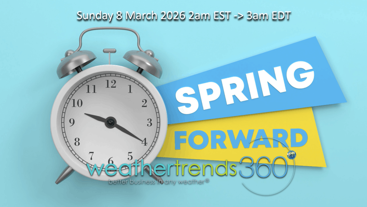
Don't forget tonight's the night to Spring Ahead 1 hour as Daylight Savings Time starts at 2am Sunday morning. CLICK ON IMAGES FOR A LARGER VIEW.

Only 13 days until the sun says Spring is here (20 Mar '26 10:46am EDT), unfortunately the weather won't cooperate in the Great Lakes and Northeast with a colder/snowier pattern ahead.
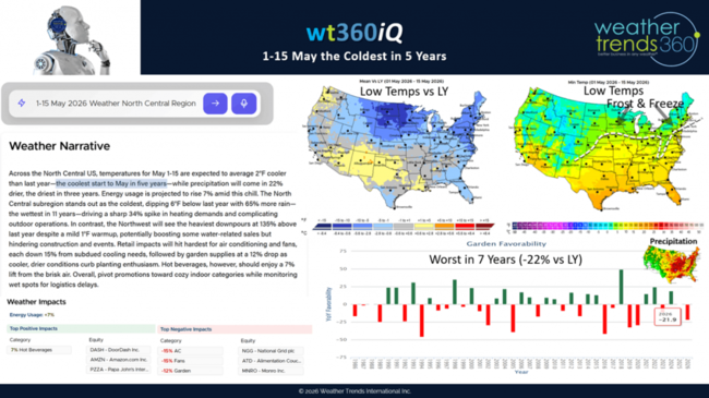
Today's wt360 AI question is on the risk for a late frost and freeze in early to middle May. The highest risk regions will be the Midwest to the Northeast with the coldest conditions in 5 to 6 years across the region. Unfortunately this has the Garden Category sales index -22% vs last year for this period and the worst in 7 years when combined with heavy rain.
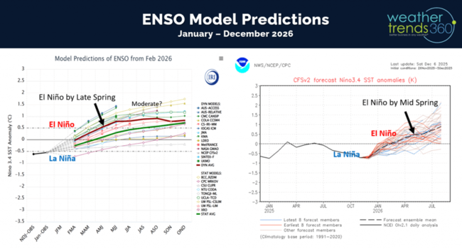
El Niño is going to become the buzz word this Spring with a rapid onset. Some models suggest the potential for a strong El Niño later this year with significant impacts to the weather pattern in the year ahead.
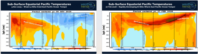
Rapid warming across the Sub-surface Equatorial Pacific Ocean shows a very large area of much above average ocean temperatures beginning to percolate to the surface.
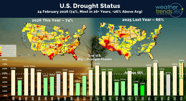
One major benefit will be drought busting rains as we go through Summer and Fall this year. Currently 74% of the U.S. is in dry to drought phases, most in 26+ years, but this is likely to plummet to most of the U.S. in a WET pattern by Fall 2026.

U.S. Season-t0-date snowfall continues to show the East with the most snow in 11 years, while the West is the least in over 41 years. U.S. overall trending +8% vs last year and the most in 5 years.

The U.S. cold days index dropped below last year by a hair and now 8th least in 41 years for the August - March period.

There's a chance the 3rd week of March could be the 2nd snowiest period of Winter with a colder stormier pattern setting up in the East.

Last week (1-7 March) across the World shows the U.S. trending +6.4F warmer than last year, warmest in 34 years and 2nd warmest in 41 years. Snowfall was down -62%, least in 5 years and 5th least in 41 years, while rainfall was up +8% vs LY and 11th most in 41 years. This time of year, warmer and drier weather is better, so we had half the equation for stronger store traffic and Spring seasonal sales. Colder and snowier across Canada was unfavorable. It continues to trend wet across Brazil benefiting their agriculture crops.

With the milder week, FLU cases continue to fall and now trending -35% vs last year's high cases. This is a minor positive for store traffic with a healthier population. With the pending cold snap, a chance for a brief uptick mid to late March.
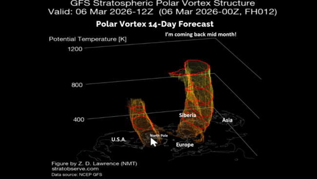
The Polar Vortex shows a weak, splitting vortex in the weeks ahead which allows the cold air at the North Pole to head South. That appears to be the case around the 14th with a strong Arctic front invading the Upper Midwest and diving South and East toward the Middle Atlantic for the 3rd week of March.
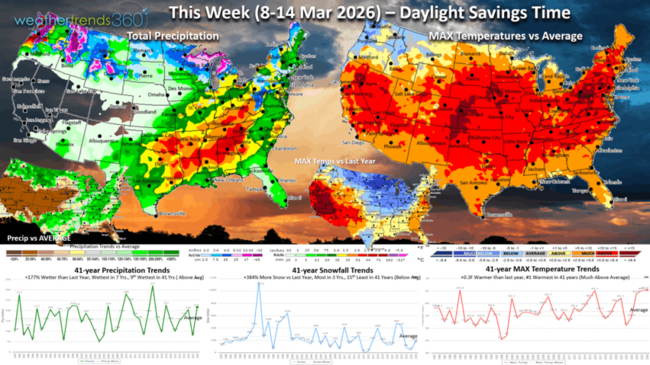
This week (8-14 Mar) shows most of the U.S. with much above average temperatures and #1 warmest in over 41 years. But from a YOY perspective, the Central U.S. is much colder than a year ago. Snowfall is up +384%, most in 3 years but still below average while rainfall is up +177%, most in 7 years and 9th most in 41 years. So, the heavier precipitation will be a limiting factor for seasonal sales despite the very warm conditions.
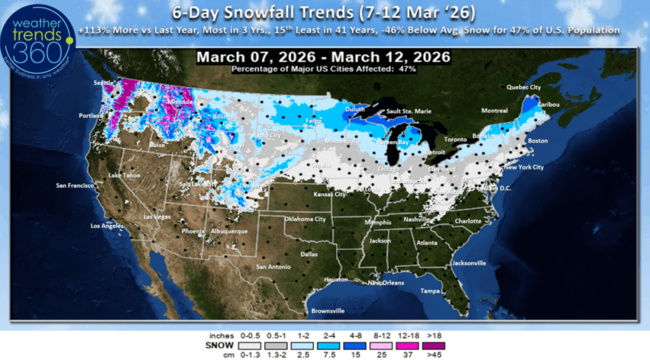
The 6-day snowfall outlook (7-12 Mar) shows 47% of the U.S. getting some light snow with +113% more than last year, most in 3 years but 15th least in 41 years.

Next week (15-21 Mar) shows signs of a cross Polar Vortex flow bringing in much colder weather from the Midwest to the Middle Atlantic. This region is the coldest in 8 years while the Southwest bakes the warmest in 41+ years. The U.S. overall trends -2.2F colder than last year but 12th warmest in 41 years. Snowfall is way up +425% over last year, most in 9 years and 2nd most in 41 years. Rainfall up +85% over LY, wettest in 23 years and 4th wettest in 41 years. These are very negative trends for Spring seasonal sales, especially in the Eastern half of the U.S.

The 2-week World Temperature outlook (8-21 Mar) is a little misleading, blending very warm weather with a colder mid-March pattern. Canada is very cold, while Central and Eastern Europe is very warm.

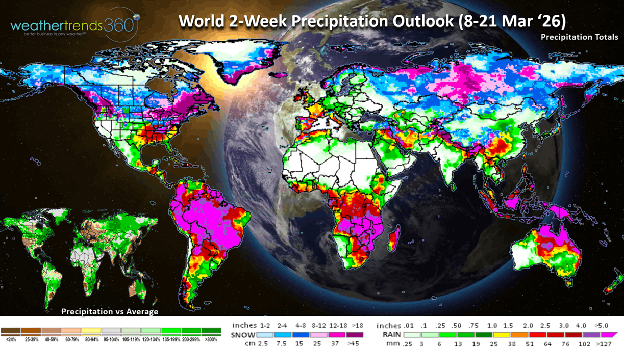
The 2-week World Precipitation outlook (8-21 Mar) shows a much stormier pattern across North and South America. The U.S. trends the wettest in 28 years and snowiest in 9 years, a negative for store traffic and Spring garden categories.
You can get this blog/video in your email inbox every Saturday (FREE) via subscription.
Have a great week ahead, and don't forget to follow us on social media for updates: Facebook, Twitter(X), YouTube, Pinterest and Linkedin.
- Captain Kirk out (USAF Gulf War Veteran 1989-1999)
Don't forget tonight's the night to Spring Ahead 1 hour as Daylight Savings Time starts at 2am Sunday morning. CLICK ON IMAGES FOR A LARGER VIEW.
Only 13 days until the sun says Spring is here (20 Mar '26 10:46am EDT), unfortunately the weather won't cooperate in the Great Lakes and Northeast with a colder/snowier pattern ahead.
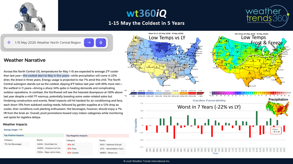
Today's wt360 AI question is on the risk for a late frost and freeze in early to middle May. The highest risk regions will be the Midwest to the Northeast with the coldest conditions in 5 to 6 years across the region. Unfortunately this has the Garden Category sales index -22% vs last year for this period and the worst in 7 years when combined with heavy rain.
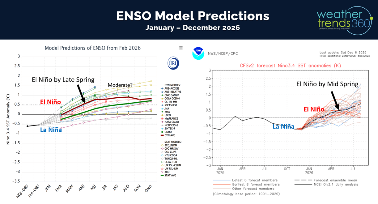
El Niño is going to become the buzz word this Spring with a rapid onset. Some models suggest the potential for a strong El Niño later this year with significant impacts to the weather pattern in the year ahead.
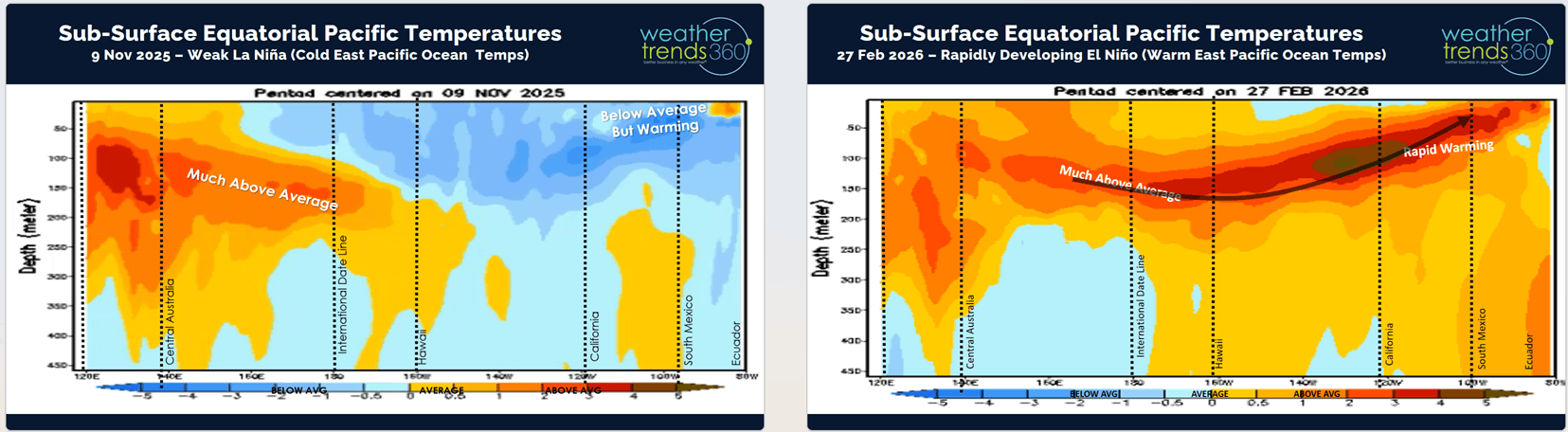
Rapid warming across the Sub-surface Equatorial Pacific Ocean shows a very large area of much above average ocean temperatures beginning to percolate to the surface.
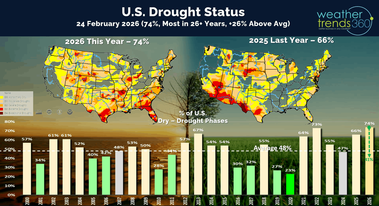
One major benefit will be drought busting rains as we go through Summer and Fall this year. Currently 74% of the U.S. is in dry to drought phases, most in 26+ years, but this is likely to plummet to most of the U.S. in a WET pattern by Fall 2026.
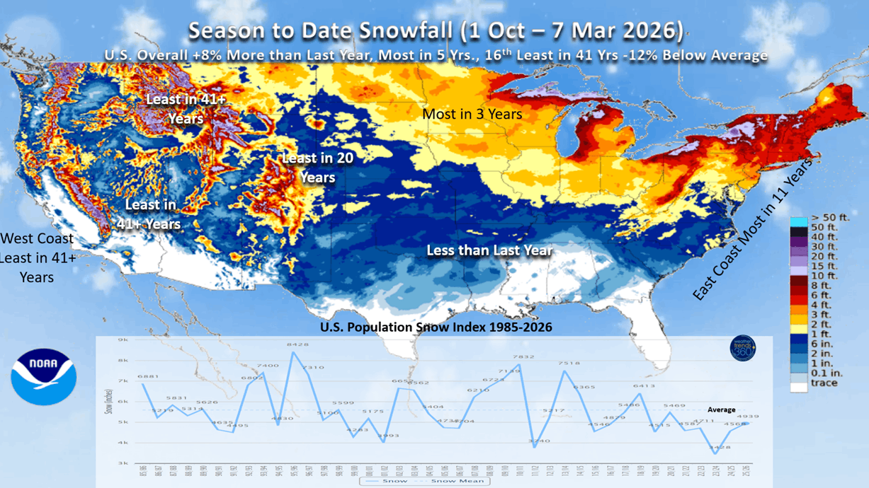
U.S. Season-t0-date snowfall continues to show the East with the most snow in 11 years, while the West is the least in over 41 years. U.S. overall trending +8% vs last year and the most in 5 years.
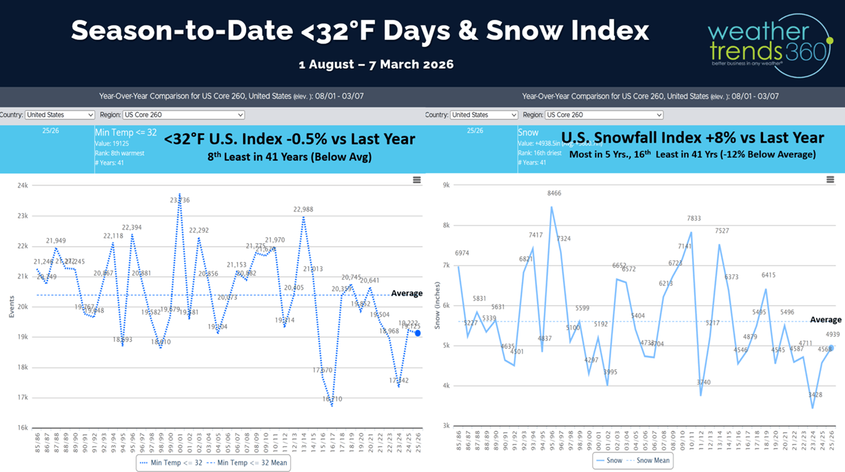
The U.S. cold days index dropped below last year by a hair and now 8th least in 41 years for the August - March period.
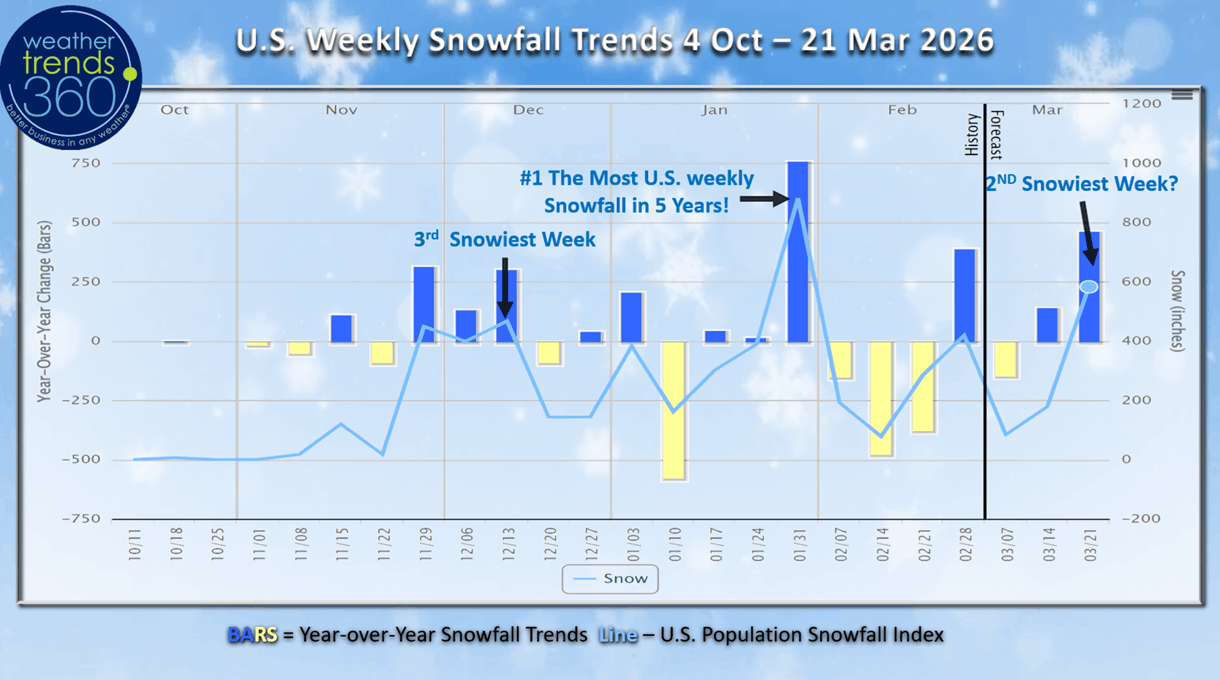
There's a chance the 3rd week of March could be the 2nd snowiest period of Winter with a colder stormier pattern setting up in the East.
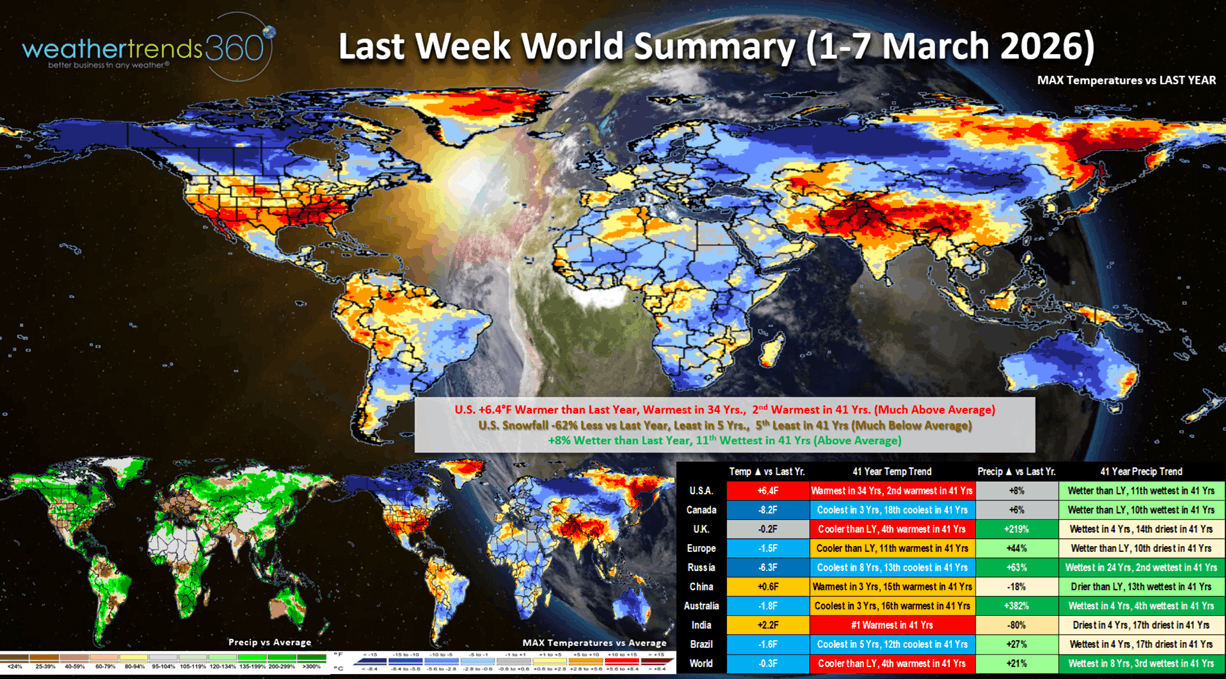
Last week (1-7 March) across the World shows the U.S. trending +6.4F warmer than last year, warmest in 34 years and 2nd warmest in 41 years. Snowfall was down -62%, least in 5 years and 5th least in 41 years, while rainfall was up +8% vs LY and 11th most in 41 years. This time of year, warmer and drier weather is better, so we had half the equation for stronger store traffic and Spring seasonal sales. Colder and snowier across Canada was unfavorable. It continues to trend wet across Brazil benefiting their agriculture crops.
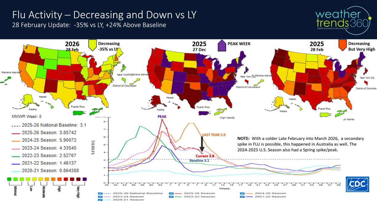
With the milder week, FLU cases continue to fall and now trending -35% vs last year's high cases. This is a minor positive for store traffic with a healthier population. With the pending cold snap, a chance for a brief uptick mid to late March.

The Polar Vortex shows a weak, splitting vortex in the weeks ahead which allows the cold air at the North Pole to head South. That appears to be the case around the 14th with a strong Arctic front invading the Upper Midwest and diving South and East toward the Middle Atlantic for the 3rd week of March.

This week (8-14 Mar) shows most of the U.S. with much above average temperatures and #1 warmest in over 41 years. But from a YOY perspective, the Central U.S. is much colder than a year ago. Snowfall is up +384%, most in 3 years but still below average while rainfall is up +177%, most in 7 years and 9th most in 41 years. So, the heavier precipitation will be a limiting factor for seasonal sales despite the very warm conditions.
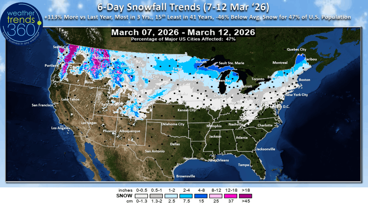
The 6-day snowfall outlook (7-12 Mar) shows 47% of the U.S. getting some light snow with +113% more than last year, most in 3 years but 15th least in 41 years.
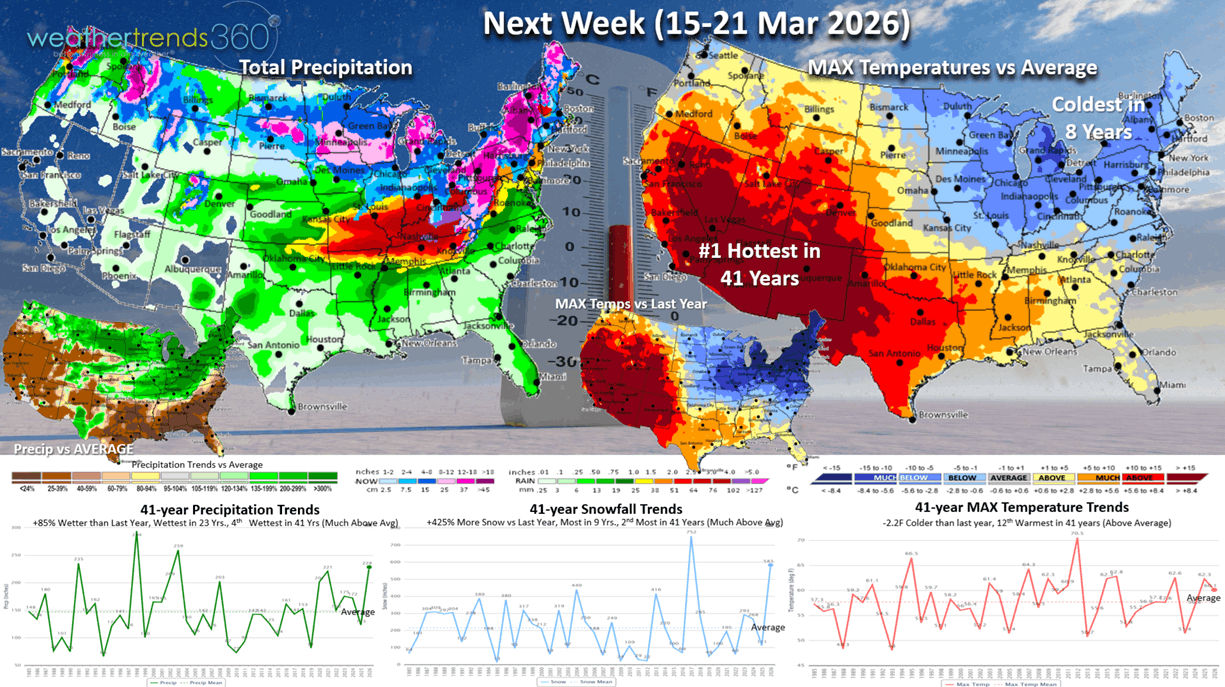
Next week (15-21 Mar) shows signs of a cross Polar Vortex flow bringing in much colder weather from the Midwest to the Middle Atlantic. This region is the coldest in 8 years while the Southwest bakes the warmest in 41+ years. The U.S. overall trends -2.2F colder than last year but 12th warmest in 41 years. Snowfall is way up +425% over last year, most in 9 years and 2nd most in 41 years. Rainfall up +85% over LY, wettest in 23 years and 4th wettest in 41 years. These are very negative trends for Spring seasonal sales, especially in the Eastern half of the U.S.
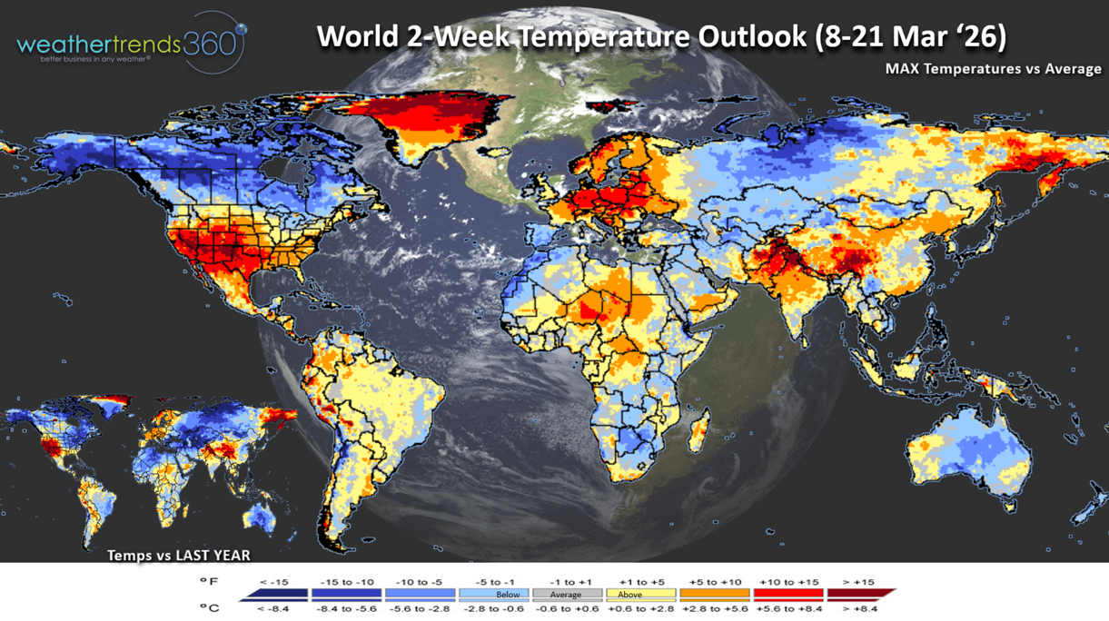
The 2-week World Temperature outlook (8-21 Mar) is a little misleading, blending very warm weather with a colder mid-March pattern. Canada is very cold, while Central and Eastern Europe is very warm.
The 2-week World Precipitation outlook (8-21 Mar) shows a much stormier pattern across North and South America. The U.S. trends the wettest in 28 years and snowiest in 9 years, a negative for store traffic and Spring garden categories.
You can get this blog/video in your email inbox every Saturday (FREE) via subscription.
Have a great week ahead, and don't forget to follow us on social media for updates: Facebook, Twitter(X), YouTube, Pinterest and Linkedin.
- Captain Kirk out (USAF Gulf War Veteran 1989-1999)