4 Oct '25 Captain's Blog: Mild & Dry BUT Signs of a Colder Pattern Ahead
Captain's Log
4 Oct '25: Happy Saturday! :)
wt360 SVP Client Services (meteorologist) Krissy Klinger is touring Iceland where it's the warmest in 9 years, but also the wettest in 10 years this week. She's pictured here in Bjarnafoss located on the Snaefellsnes Peninsula in western Iceland; since she has her wt360 shirt on we'll consider this marketing. :) CLICK ON IMAGES FOR A LARGER VIEW

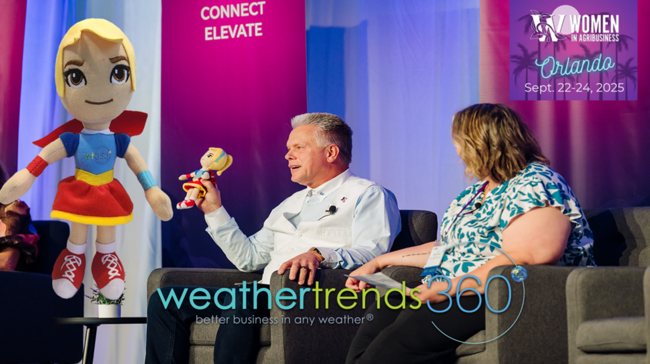
Our superhero mascot wt360 girl is making the rounds from Florida last week at the Women in Agribusiness Summit, Iceland this week and New York City DOMO Connections AI Tour 21 October. We look forward to meeting you in NYC for this free DOMO event.
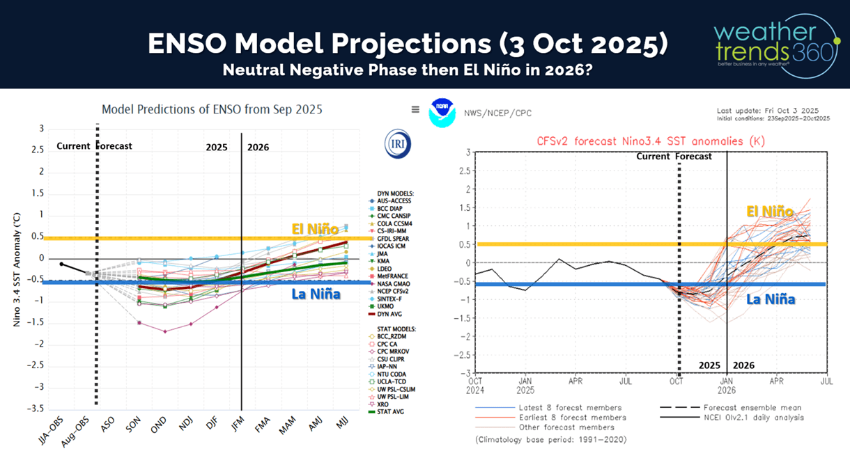
Back to the weather as there are several major climate indices taking shape that are pointing to a big pattern shift this Fall-Winter and well into 2026. While there is buzz about a weak La Niña (cooling of the equatorial Pacific Ocean) again, it's is more likely just a weak negative phase that won't last very long before a warming trend takes shape suggesting an El Niño in 2026 is becoming more likely.

Most models show this brief dip of cooler Equatorial Ocean temperatures and then a rapid warming trend in Spring 2026. In part why we're forecasting a very cool and wet Spring in the U.S. and Brazil (wettest in 14 years).

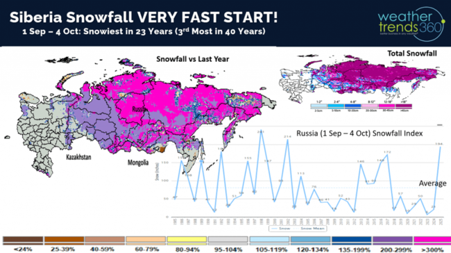
Another climate cycle teleconnection is the speed at which snowfall in Siberia begins to take shape and that's off to the fastest start 23 years! There is some research to suggest heavy early snowpack in Russia leads to a weaker Polar Vortex in turn allowing Arctic Air to move more freely across North America and Europe - aka ANOTHER COLD WINTER AHEAD! A weaker neutral ENSO phase also suggests for bigger snowstorms the latter half of Winter into Spring as well in the U.S. Q1 2026 in the U.S. looks VERY CHALLENGING for seasonal sales.
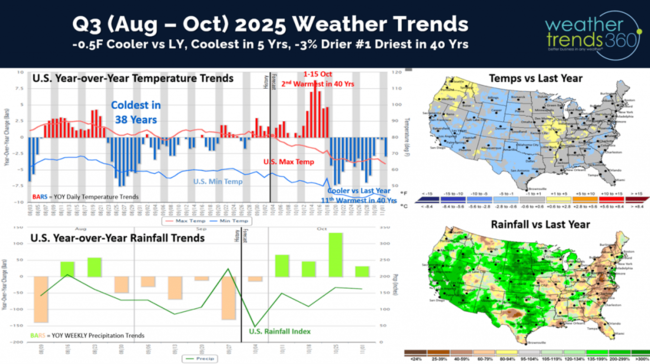
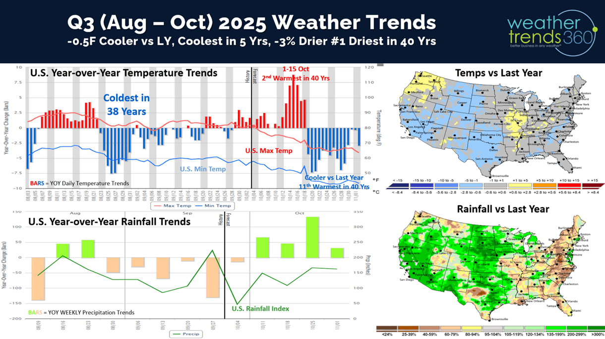
Q3 (Aug - Oct) showed the most favorable period for colder weather was around Labor Day when the U.S. was the coldest in 38 years, but now the front half of October trending the 2nd warmest in 40 years. But, there are signs of a cooler/wetter pattern for the latter half of October which should bring a boost in early Fall seasonal categories. The quarter overall looks to trend the coolest in 5 years (still above average) and -3% drier than last year, making it the #1 driest in 40 years. Still need to watch for a landfalling hurricane along the East Coast over the next month.
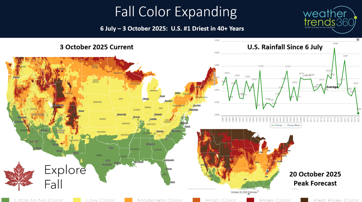
Since July 4th weekend, the U.S. is now trending the #1 driest in 40 years. The exceptionally dry pattern will have Fall leaves peaking early and falling very quickly with stressed trees. Drought years can bring nice Fall color, but trees also go in stages and fall quickly, so enjoy it while it lasts.

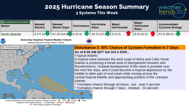
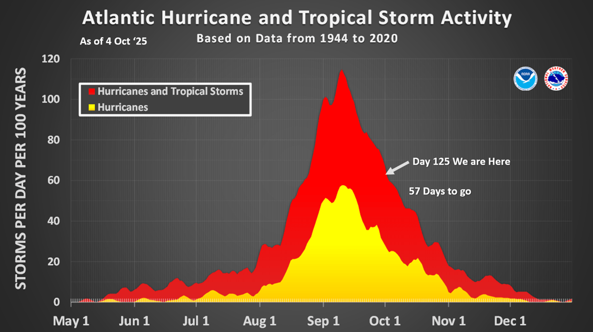
We're in Day 125 of the Hurricane Season with 57 days to go. Several systems have traversed well of the East Coast, but that pattern will continue so the threats of a landfalling hurricane will continue into October, early November.

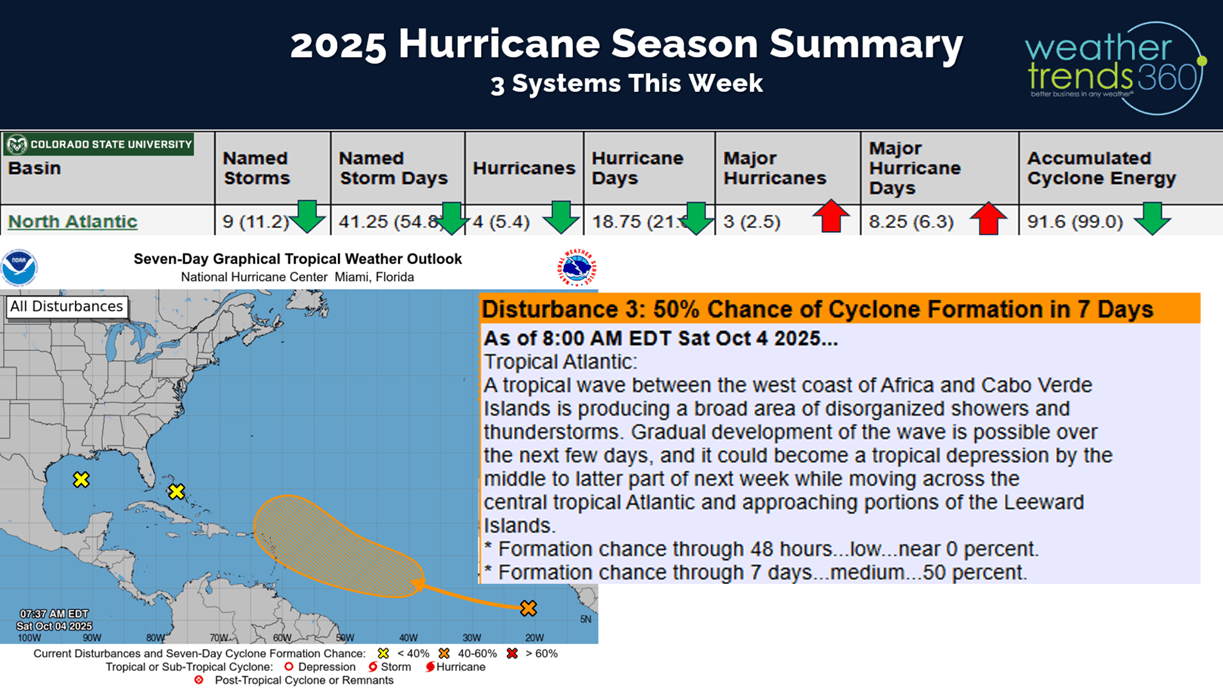
The National Hurricane Center is watching three threat areas, the most likely to develop is a system coming off Africa. These are the ones to watch as the traverse the Atlantic taking 10-14 days to reach the U.S.
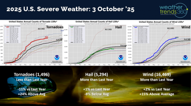
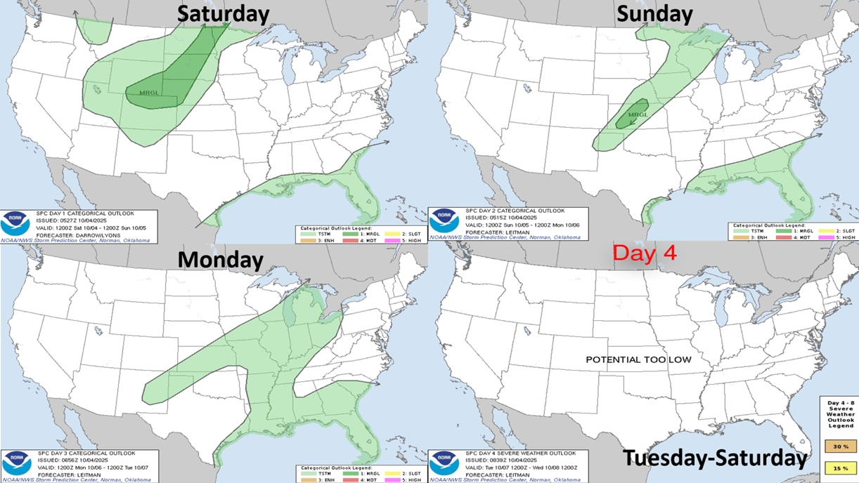
Not much severe weather last week with Tornadoes year-to-date down -11% vs last year, hail +1% vs last year and wind cases +2% vs last year.
The week ahead outlook doesn't show much in the way of severe weather, some marginal risk in the Central U.S. Sunday.

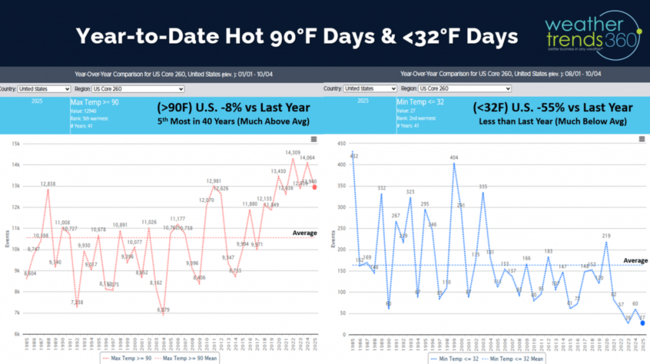
Hot 90F days year-to-date are down -8% vs last year but still 5th most in 40 years, while cold <32F days are off to a slow start down -55% vs last year and 2nd least in 40 years.
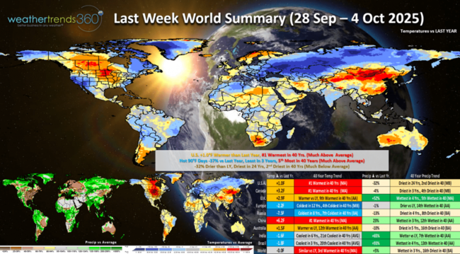
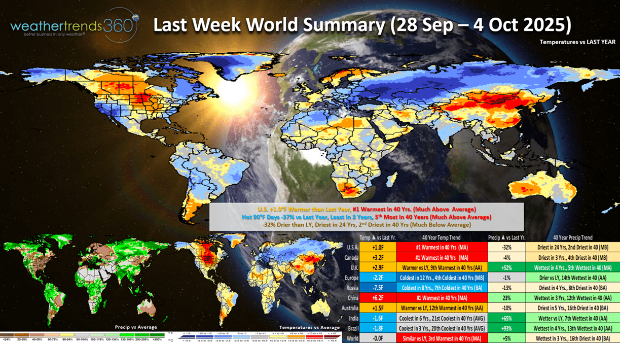
Last week (28 Sep - 4 Oct) across the World shows the U.S. trending +1.0F warmer than last year and #1 warmest of the past 40 years. Hot 90F days were down -37% vs LY, least in 3 years, but still 5th most in 40 years, while rainfall was down -32% vs LY, driest in 24 years and 2nd driest in 40 years. The interior Northeast had their first frost and freezes late in the week. These are generally unfavorable trends for Fall seasonal merchandise, except outdoor categories that benefit Home Centers. Home Centers are up against tough comparisons to last year when we had 4 land falling hurricanes that brought a 2% bounce in total company sales. See our white paper on how hurricanes impact sales and stock prices. CASE STUDY
Very warm in Canada, coldest in 12 years across Europe and coldest in 8 years across Russia.
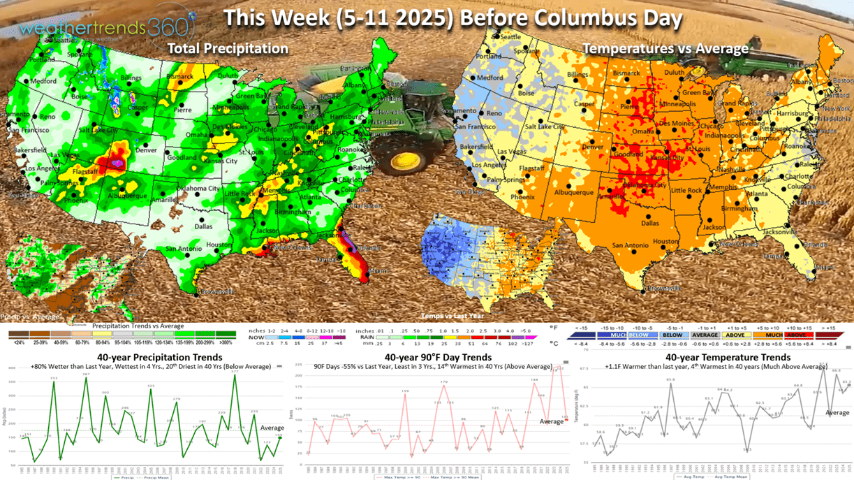
This week (5-11 Oct) prior Columbus Day shows continued warm weather with the U.S. trending +1.1F warmer than last year, 4th warmest in 40 years, but hot 90F days are way down -55% vs LY, least in 3 years and 14th most of the past 40 years. Rainfall up +80%, wettest in 4 years and 20th driest of the past 40 years. Need to watch for tropical systems that could develop quickly across the Southeast U.S. The most favorable areas for early Fall merchandise would be the West Coast. The first significant snows are possible in the higher terrain of the Northern Rockies (MT, WY). With the dry weather, the Fall harvest is off to a very fast start with a huge corn crop in the U.S.

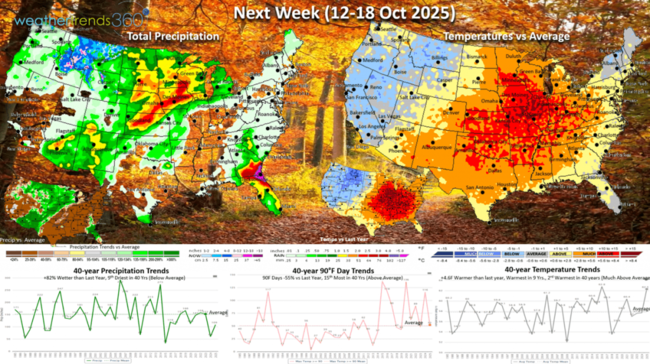
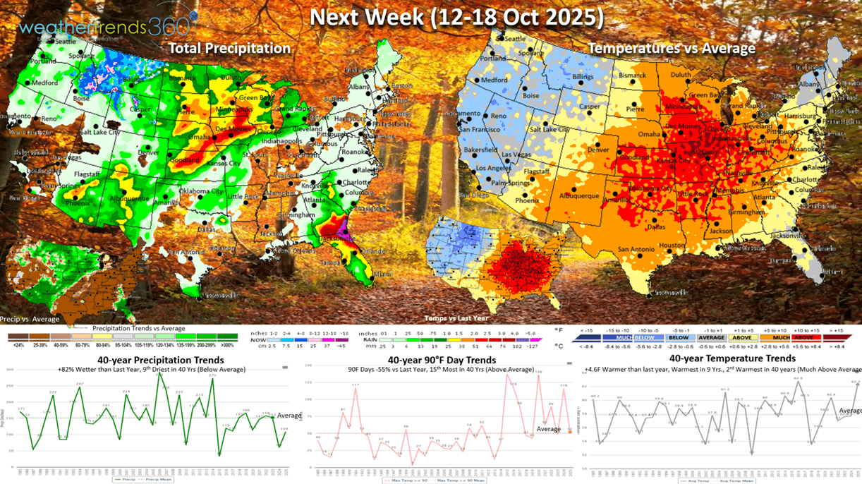
Next week (12-18 Oct) shows a potential cold front that will start in the West but begin to head East. It will be very warm ahead of this front, so the U.S. overall trends +4.6F warmer than last year, warmest in 9 years and 2nd warmest of the past 40 years. But hot 90F days are down -55% vs last year, while rainfall is up +82 vs LY, still 9th driest of the past 40 years. The West and Northern Rockies are the most favored areas for Fall merchandise with more snow in the higher elevations.
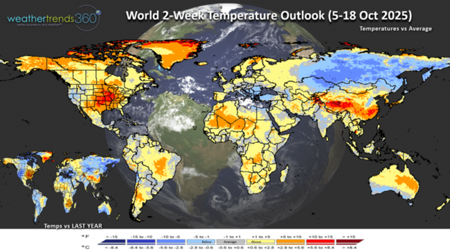
The World 2-week (5-18 Oct) temperature outlook shows the warm conditions in the U.S. with more seasonable weather in Europe. It remains very cold across Siberia.
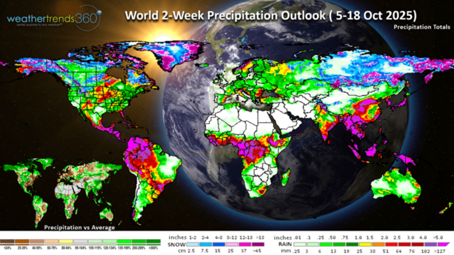
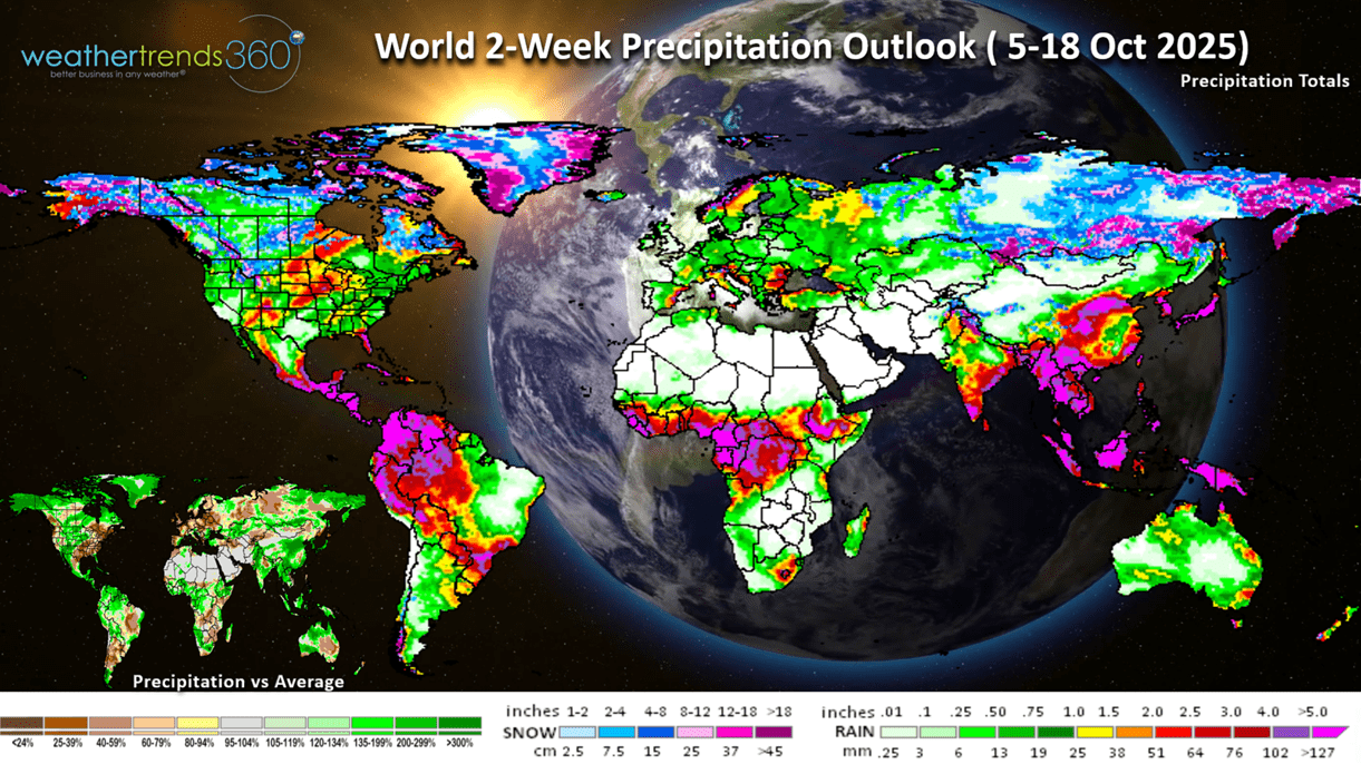
The World 2-week (5-18 Oct) precipitation outlook shows a wetter pattern in the Central U.S. but continued dry in the East. Heavy snow across Alaska! Dry across Europe and the U.K.
Have a great week ahead, and don't forget to follow us on social media for frequent updates: Facebook, Twitter(X), YouTube, Pinterest and Linkedin.
- Captain Kirk out
wt360 SVP Client Services (meteorologist) Krissy Klinger is touring Iceland where it's the warmest in 9 years, but also the wettest in 10 years this week. She's pictured here in Bjarnafoss located on the Snaefellsnes Peninsula in western Iceland; since she has her wt360 shirt on we'll consider this marketing. :) CLICK ON IMAGES FOR A LARGER VIEW

Our superhero mascot wt360 girl is making the rounds from Florida last week at the Women in Agribusiness Summit, Iceland this week and New York City DOMO Connections AI Tour 21 October. We look forward to meeting you in NYC for this free DOMO event.

Back to the weather as there are several major climate indices taking shape that are pointing to a big pattern shift this Fall-Winter and well into 2026. While there is buzz about a weak La Niña (cooling of the equatorial Pacific Ocean) again, it's is more likely just a weak negative phase that won't last very long before a warming trend takes shape suggesting an El Niño in 2026 is becoming more likely.
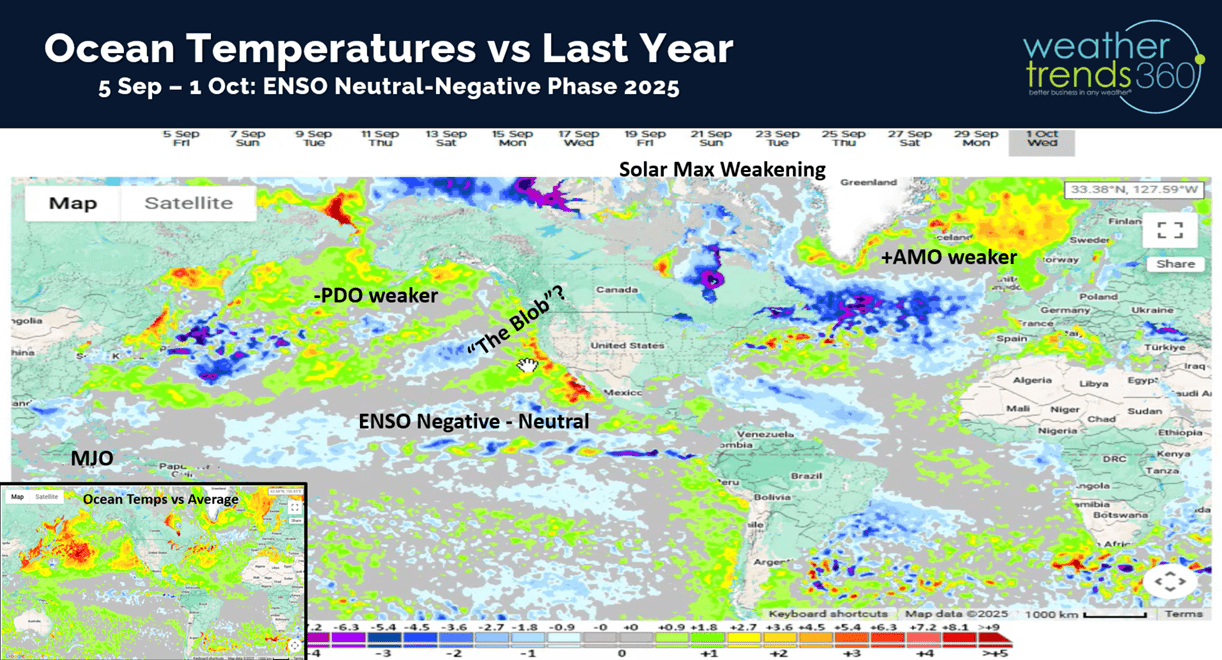
Most models show this brief dip of cooler Equatorial Ocean temperatures and then a rapid warming trend in Spring 2026. In part why we're forecasting a very cool and wet Spring in the U.S. and Brazil (wettest in 14 years).
Another climate cycle teleconnection is the speed at which snowfall in Siberia begins to take shape and that's off to the fastest start 23 years! There is some research to suggest heavy early snowpack in Russia leads to a weaker Polar Vortex in turn allowing Arctic Air to move more freely across North America and Europe - aka ANOTHER COLD WINTER AHEAD! A weaker neutral ENSO phase also suggests for bigger snowstorms the latter half of Winter into Spring as well in the U.S. Q1 2026 in the U.S. looks VERY CHALLENGING for seasonal sales.

Q3 (Aug - Oct) showed the most favorable period for colder weather was around Labor Day when the U.S. was the coldest in 38 years, but now the front half of October trending the 2nd warmest in 40 years. But, there are signs of a cooler/wetter pattern for the latter half of October which should bring a boost in early Fall seasonal categories. The quarter overall looks to trend the coolest in 5 years (still above average) and -3% drier than last year, making it the #1 driest in 40 years. Still need to watch for a landfalling hurricane along the East Coast over the next month.
Since July 4th weekend, the U.S. is now trending the #1 driest in 40 years. The exceptionally dry pattern will have Fall leaves peaking early and falling very quickly with stressed trees. Drought years can bring nice Fall color, but trees also go in stages and fall quickly, so enjoy it while it lasts.
We're in Day 125 of the Hurricane Season with 57 days to go. Several systems have traversed well of the East Coast, but that pattern will continue so the threats of a landfalling hurricane will continue into October, early November.
The National Hurricane Center is watching three threat areas, the most likely to develop is a system coming off Africa. These are the ones to watch as the traverse the Atlantic taking 10-14 days to reach the U.S.
Not much severe weather last week with Tornadoes year-to-date down -11% vs last year, hail +1% vs last year and wind cases +2% vs last year.

The week ahead outlook doesn't show much in the way of severe weather, some marginal risk in the Central U.S. Sunday.
Hot 90F days year-to-date are down -8% vs last year but still 5th most in 40 years, while cold <32F days are off to a slow start down -55% vs last year and 2nd least in 40 years.

Last week (28 Sep - 4 Oct) across the World shows the U.S. trending +1.0F warmer than last year and #1 warmest of the past 40 years. Hot 90F days were down -37% vs LY, least in 3 years, but still 5th most in 40 years, while rainfall was down -32% vs LY, driest in 24 years and 2nd driest in 40 years. The interior Northeast had their first frost and freezes late in the week. These are generally unfavorable trends for Fall seasonal merchandise, except outdoor categories that benefit Home Centers. Home Centers are up against tough comparisons to last year when we had 4 land falling hurricanes that brought a 2% bounce in total company sales. See our white paper on how hurricanes impact sales and stock prices. CASE STUDY
Very warm in Canada, coldest in 12 years across Europe and coldest in 8 years across Russia.
This week (5-11 Oct) prior Columbus Day shows continued warm weather with the U.S. trending +1.1F warmer than last year, 4th warmest in 40 years, but hot 90F days are way down -55% vs LY, least in 3 years and 14th most of the past 40 years. Rainfall up +80%, wettest in 4 years and 20th driest of the past 40 years. Need to watch for tropical systems that could develop quickly across the Southeast U.S. The most favorable areas for early Fall merchandise would be the West Coast. The first significant snows are possible in the higher terrain of the Northern Rockies (MT, WY). With the dry weather, the Fall harvest is off to a very fast start with a huge corn crop in the U.S.
Next week (12-18 Oct) shows a potential cold front that will start in the West but begin to head East. It will be very warm ahead of this front, so the U.S. overall trends +4.6F warmer than last year, warmest in 9 years and 2nd warmest of the past 40 years. But hot 90F days are down -55% vs last year, while rainfall is up +82 vs LY, still 9th driest of the past 40 years. The West and Northern Rockies are the most favored areas for Fall merchandise with more snow in the higher elevations.
The World 2-week (5-18 Oct) temperature outlook shows the warm conditions in the U.S. with more seasonable weather in Europe. It remains very cold across Siberia.

The World 2-week (5-18 Oct) precipitation outlook shows a wetter pattern in the Central U.S. but continued dry in the East. Heavy snow across Alaska! Dry across Europe and the U.K.
Have a great week ahead, and don't forget to follow us on social media for frequent updates: Facebook, Twitter(X), YouTube, Pinterest and Linkedin.
- Captain Kirk out