29 Nov '25 wt360 Weather Brief - Snowiest Thanksgiving in 40+ Years
Captain's Log
29 Nov '25: Happy Saturday :)
Today's wt360 AI Power of 1 Degree weather summary on the Thanksgiving weekend (27-30 Nov) shows the snowiest Thanksgiving for the U.S. overall in over 40 years! East Coast heaters were a top pick category with projected sales +34% vs LY, while the West Coast was down -46%. Snow categories certainly a big winner with nearly 300% more snow than last year from Montana to the Great Lakes. CLICK ON IMAGES FOR A LARGER VIEW.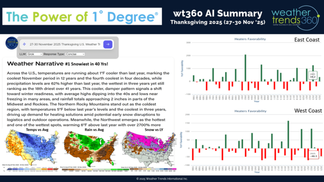
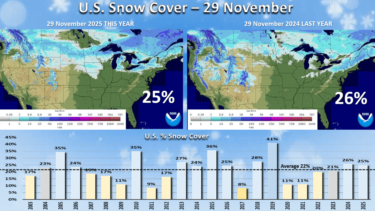
Snow Cover this morning stood at 25%, similar to last year's 26%, but more snow in the Central U.S. and less in the West. This will increase dramatically over the next 5-days into the East.
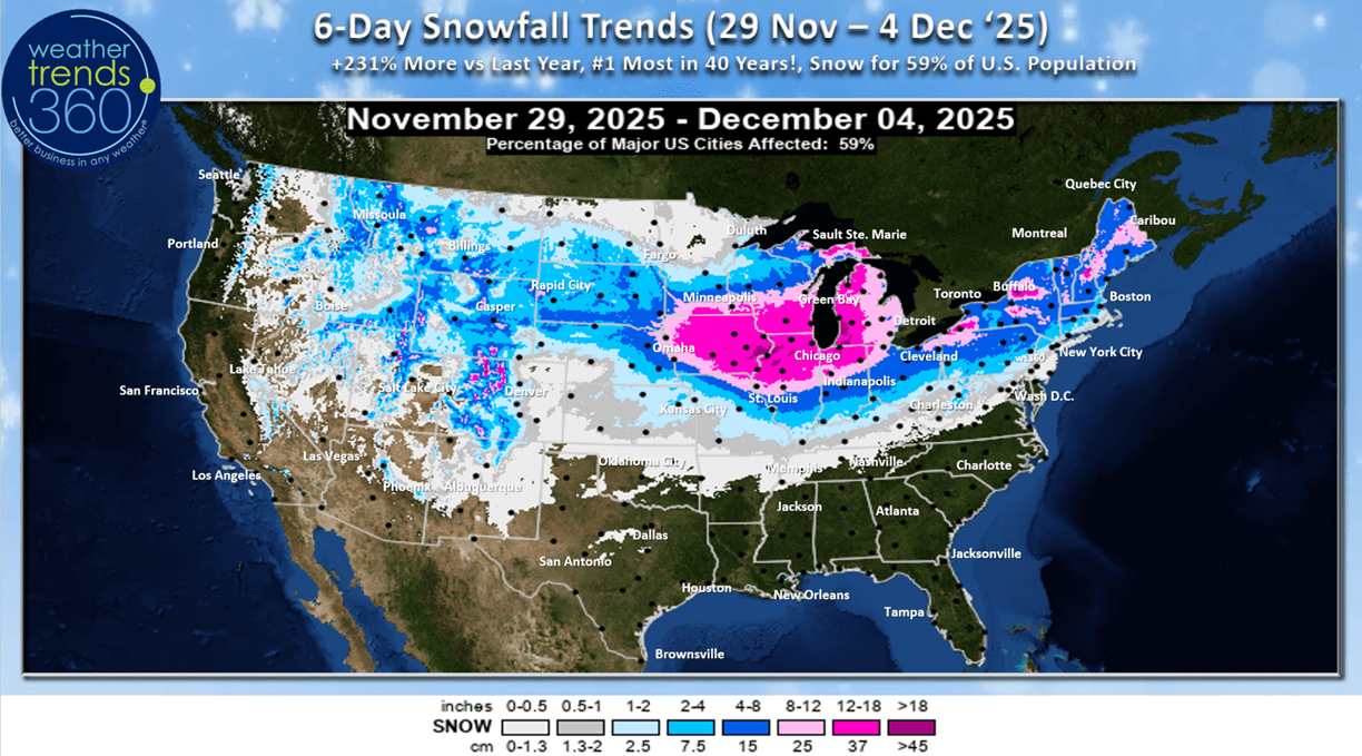
The 6-day snowfall 29 Nov - 4 Dec) outlook shows the big Midwest storm with 59% of the U.S. getting some snow. Snowfall trends are +231% more than last year and #1 most in 40 years for the U.S. overall with two systems traversing the U.S.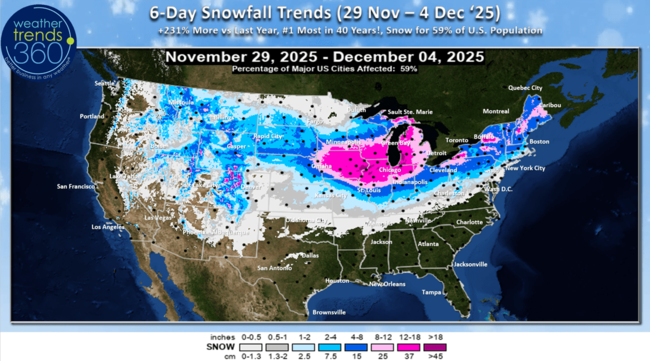
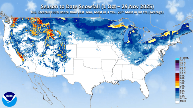
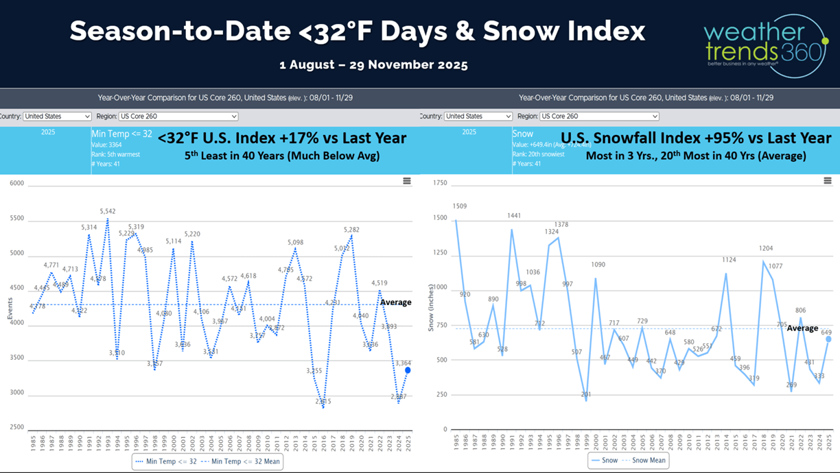
NOAA's season-to-date snowfall shows below average conditions in the West, but above average in the Great Lakes-Northeast. wt360 projects snowfall season-to-date nationally up +96% vs last year, most in 3 years and 20th most in 40 years (near average).
 World snowfall estimates show we're off to a much snowier start across much of the Northern Hemisphere with 300%+ more snow than last year across much of Canada, the Northern half of the U.S. Southern Europe and SW Russia.
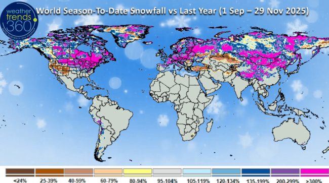 This suggests a cold Winter ahead with the heavier snow pack.
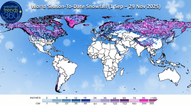
The U.S. snowfall index shows the huge surge in snow this week and a moderating trend over the next two weeks, but still slightly more than last year. This bodes well for a strong start to snow accessories at higher early season margins.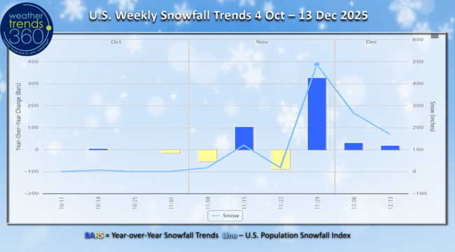
Season-t0-date cold 32F days are inching up now +17% vs last year, but still 5th least in 40 years due in large part to the warmth in the West.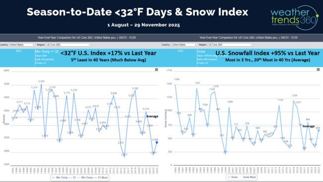
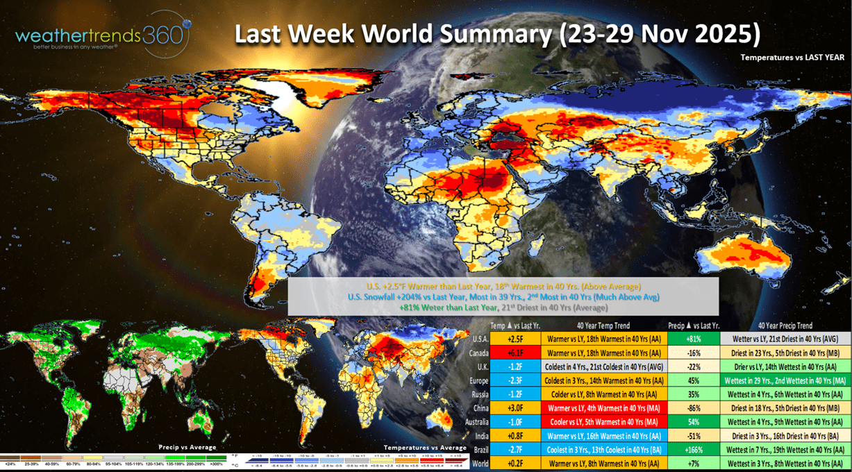
Last week (23-29 Nov) across the World shows the U.S. trending +2.5F warmer than last year and 18th warmest of the past 40 years. Snowfall was up +204% vs last year, most in 39 years and 2nd most in 40 years, while rainfall was up +81% vs LY but 21st driest of the past 40 years. The strong Polar Vortex cold front ushered in much colder weather toward the Thanksgiving weekend in the Central and East. These are good trends for seasonal merchandise, but a bit disruptive to store traffic. Cooler trends across Europe but it was the wettest in 29 years negatively impacting store traffic. Increasingly wet across Brazil will end the drought conditions of the past few years.
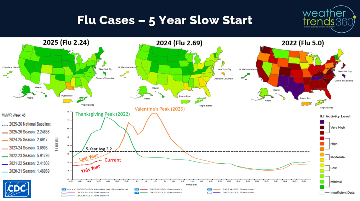
Flu cases are off to the slowest start in 5 years but starting to pick up across the Gulf Coast. Healthier consumers benefit the holiday shopping season, unlike 2022 when Flu was surging to near historic highs around Thanksgiving.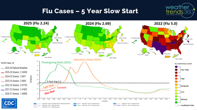
This week (30 Nov - 6 Dec) across the U.S. shows the glancing shot of the Polar Vortex with the U.S. trending -0.8F colder than last year's frigid conditions making the week the coldest in 23 years nationally. With the exiting Midwest storm, snowfall is up +13% vs last year and most in 6 years, while rainfall is up +227% more than a year ago and most in 3 years. This is very disruptive weather for travel (airline delays and cancellations go up) and store traffic. The West and Florida are the least impacted areas with warmer/drier conditions.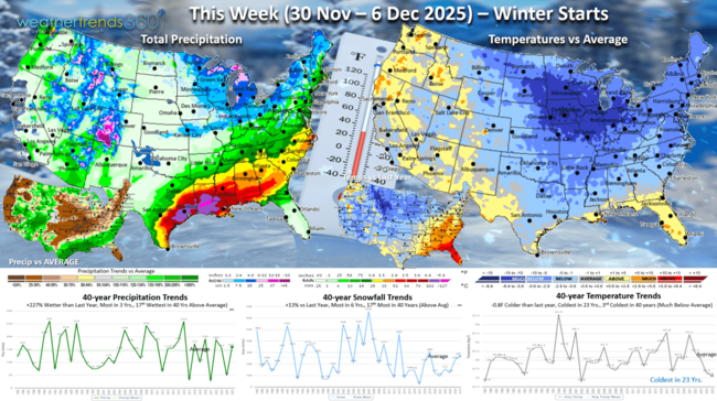
The Polar Vortex is very evident over Eastern North America, but this first surge lifts out next week. With the PV it can bring big swings from very cold to much warmer as it pulls the cold out as it retreats North.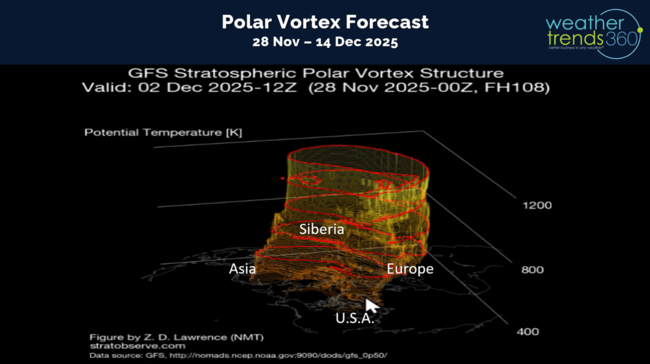
Next week (7-13 Dec) before Hanukah shows a moderating trend with lingering cold over the heavy snowpack in the Midwest and Ohio Valley. The U.S. overall trends -0.1F colder than last year, coldest in 6 years, but a big moderating trend in the Central U.S. Snowfall still up +13% vs LY and most in 4 years, while rainfall is up +1% and wettest in 6 years. Very stormy along the Gulf Coast will negatively impact store traffic but benefit on-line shopping.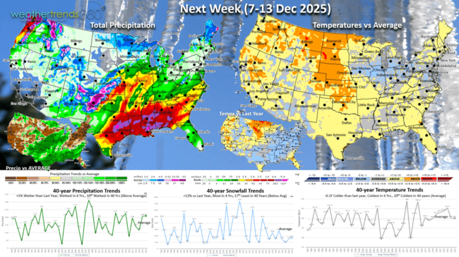
The World 2-week Temperature outlook (30 Nov - 13 Dec) shows the heart of the Polar Vortex over Eastern Canada, Eastern half of the U.S., Alaska and Central Siberia.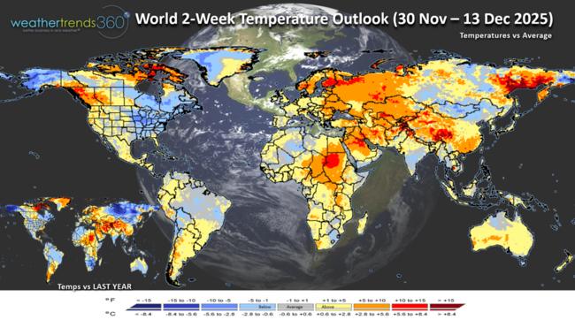
The World 2-week Precipitation outlook (30 Nov - 13 Dec) shows wet conditions across the Southern U.S. and wet for Brazil's crop regions. Generally much drier across Europe benefiting store traffic.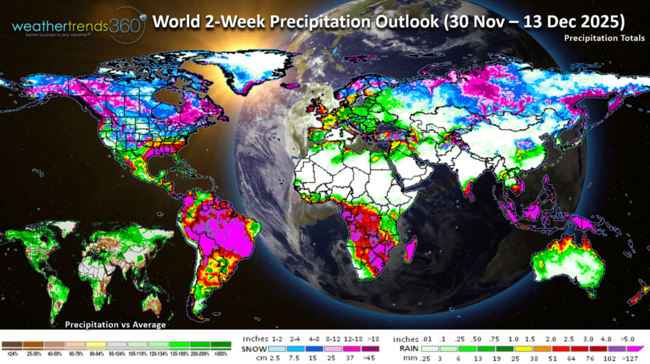
You can get this blog/video in your email inbox every Saturday (FREE) via subscription.
Have a great week ahead, and don't forget to follow us on social media for updates: Facebook, Twitter(X), YouTube, Pinterest and Linkedin.
- Captain Kirk out (USAF Gulf War Veteran 1989-1999)
Today's wt360 AI Power of 1 Degree weather summary on the Thanksgiving weekend (27-30 Nov) shows the snowiest Thanksgiving for the U.S. overall in over 40 years! East Coast heaters were a top pick category with projected sales +34% vs LY, while the West Coast was down -46%. Snow categories certainly a big winner with nearly 300% more snow than last year from Montana to the Great Lakes. CLICK ON IMAGES FOR A LARGER VIEW.

Snow Cover this morning stood at 25%, similar to last year's 26%, but more snow in the Central U.S. and less in the West. This will increase dramatically over the next 5-days into the East.
The 6-day snowfall 29 Nov - 4 Dec) outlook shows the big Midwest storm with 59% of the U.S. getting some snow. Snowfall trends are +231% more than last year and #1 most in 40 years for the U.S. overall with two systems traversing the U.S.
NOAA's season-to-date snowfall shows below average conditions in the West, but above average in the Great Lakes-Northeast. wt360 projects snowfall season-to-date nationally up +96% vs last year, most in 3 years and 20th most in 40 years (near average).
 World snowfall estimates show we're off to a much snowier start across much of the Northern Hemisphere with 300%+ more snow than last year across much of Canada, the Northern half of the U.S. Southern Europe and SW Russia.
 This suggests a cold Winter ahead with the heavier snow pack.
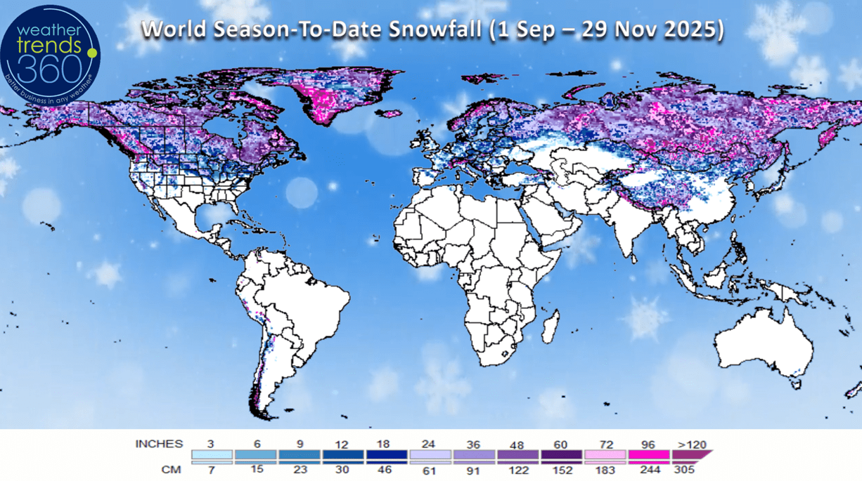
The U.S. snowfall index shows the huge surge in snow this week and a moderating trend over the next two weeks, but still slightly more than last year. This bodes well for a strong start to snow accessories at higher early season margins.

Season-t0-date cold 32F days are inching up now +17% vs last year, but still 5th least in 40 years due in large part to the warmth in the West.
Last week (23-29 Nov) across the World shows the U.S. trending +2.5F warmer than last year and 18th warmest of the past 40 years. Snowfall was up +204% vs last year, most in 39 years and 2nd most in 40 years, while rainfall was up +81% vs LY but 21st driest of the past 40 years. The strong Polar Vortex cold front ushered in much colder weather toward the Thanksgiving weekend in the Central and East. These are good trends for seasonal merchandise, but a bit disruptive to store traffic. Cooler trends across Europe but it was the wettest in 29 years negatively impacting store traffic. Increasingly wet across Brazil will end the drought conditions of the past few years.
Flu cases are off to the slowest start in 5 years but starting to pick up across the Gulf Coast. Healthier consumers benefit the holiday shopping season, unlike 2022 when Flu was surging to near historic highs around Thanksgiving.
This week (30 Nov - 6 Dec) across the U.S. shows the glancing shot of the Polar Vortex with the U.S. trending -0.8F colder than last year's frigid conditions making the week the coldest in 23 years nationally. With the exiting Midwest storm, snowfall is up +13% vs last year and most in 6 years, while rainfall is up +227% more than a year ago and most in 3 years. This is very disruptive weather for travel (airline delays and cancellations go up) and store traffic. The West and Florida are the least impacted areas with warmer/drier conditions.

The Polar Vortex is very evident over Eastern North America, but this first surge lifts out next week. With the PV it can bring big swings from very cold to much warmer as it pulls the cold out as it retreats North.

Next week (7-13 Dec) before Hanukah shows a moderating trend with lingering cold over the heavy snowpack in the Midwest and Ohio Valley. The U.S. overall trends -0.1F colder than last year, coldest in 6 years, but a big moderating trend in the Central U.S. Snowfall still up +13% vs LY and most in 4 years, while rainfall is up +1% and wettest in 6 years. Very stormy along the Gulf Coast will negatively impact store traffic but benefit on-line shopping.

The World 2-week Temperature outlook (30 Nov - 13 Dec) shows the heart of the Polar Vortex over Eastern Canada, Eastern half of the U.S., Alaska and Central Siberia.

The World 2-week Precipitation outlook (30 Nov - 13 Dec) shows wet conditions across the Southern U.S. and wet for Brazil's crop regions. Generally much drier across Europe benefiting store traffic.

You can get this blog/video in your email inbox every Saturday (FREE) via subscription.
Have a great week ahead, and don't forget to follow us on social media for updates: Facebook, Twitter(X), YouTube, Pinterest and Linkedin.
- Captain Kirk out (USAF Gulf War Veteran 1989-1999)