25 Jan '25 Captains Blog - January Thaw then Polar Vortex Returns
Captain's Log
25 Jan '25: Happy Saturday :)
For our FarmCast® clients, look for your 2025 U.S. and Global Ag outlook in your email on Monday. We have some good news for you. CLICK ON IMAGES FOR A LARGER VIEW.

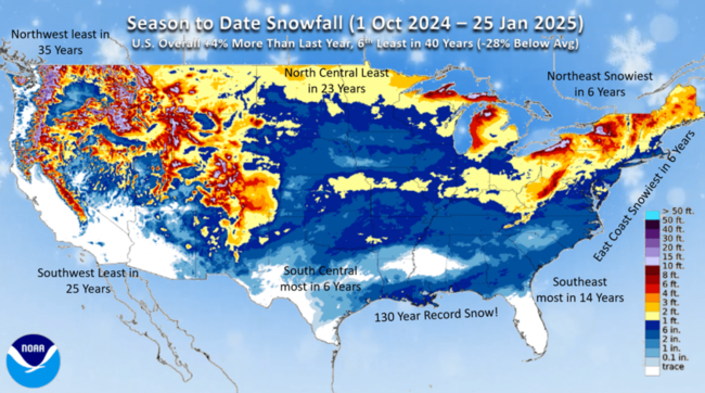
U.S. snowfall season-to-date picked up some ground with the historic Deep South snowstorm. U.S. overall now +4% more snow than last year but still 6th least of the past 40 years.
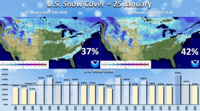
U.S. snow cover this morning stands at 37% vs 42% last year. An average year is around 41%, but the snow lingers across Louisiana to North Carolina.
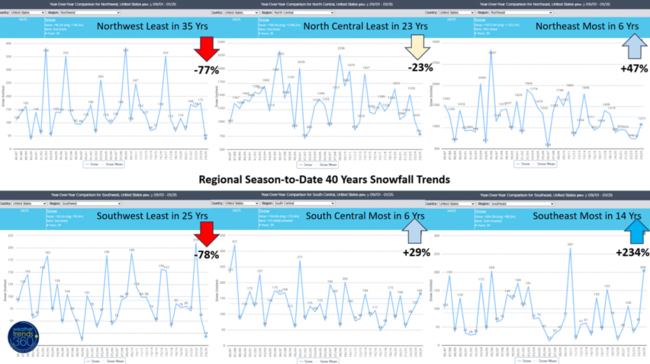
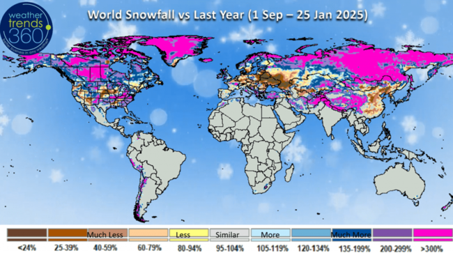
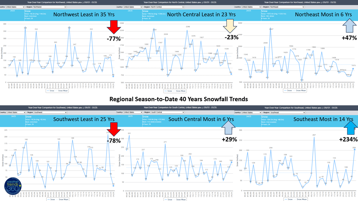
Regional snowfall trends season-t0-date show the Southeast the biggest winner with +234% more snow than last year, Northeast +47% more than last year and the South Central +29% more. The biggest declines are in the West with the Southwest down -78% and the Northwest down -77%, while the North Central is down -23%.
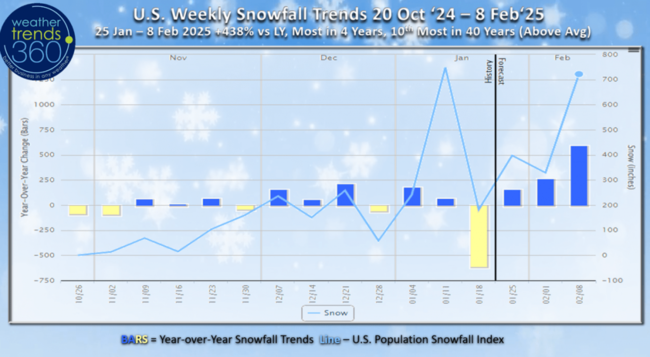
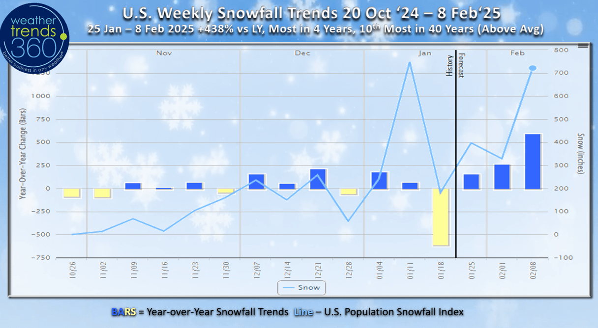
U.S. weekly snowfall trends show an uptick in snowy weeks ahead as we transition into what looks like a very storm February. 2-week snowfall trends show +438% more than last year, most in 4 years and 10th most in 40 years for the U.S. overall.
World season-to-date snowfall shows a much snowier Winter across Central Canada, Eastern U.S. and Siberia.
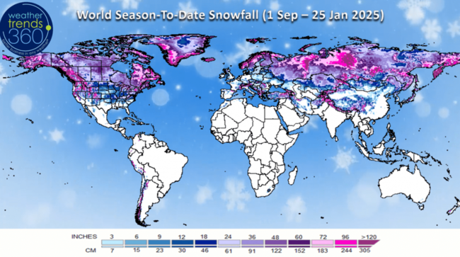
Much less snow across the Central U.S. and West and dramatically less across Europe.
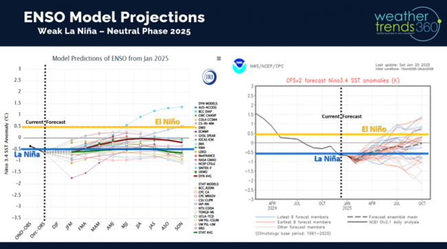
Ocean temperature trends vs last year show a very clear weak La Nina like trend, but it appears this one will be short lived.

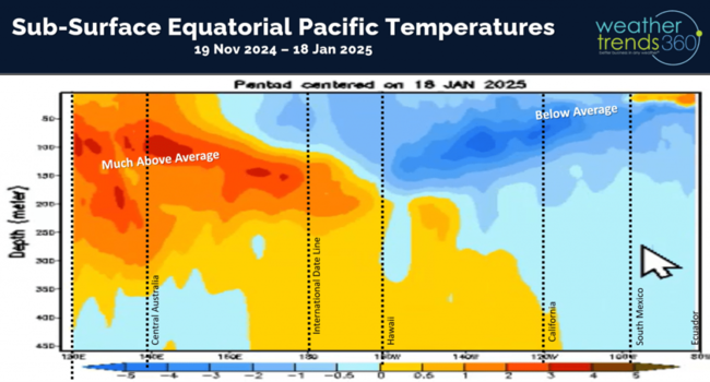
Looking below the surface of the Equatorial Pacific Ocean shows very warm waters West of Hawaii and even some warming near the surface off Ecuador.
Model guidance suggests we're headed for a neutral phase in the Pacific for the first time in 8 years.
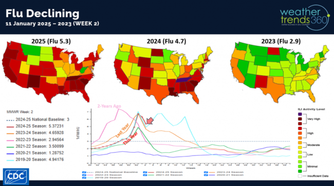
Flu has peaked and now a 2-week decline after a much later start to the season this year.
The Polar Vortex is finally retreating as we enter a somewhat typical January Thaw.
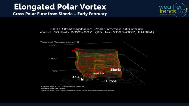
But, all signs suggest it will come roaring back in early and middle February. The Western U.S. likely to get their coldest temperatures of the season in early February.
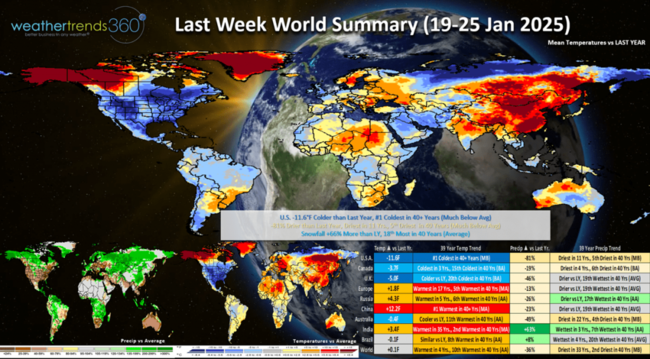
Last week (19-25 Jan) across the World shows the heart of the Polar Vortex over the U.S. with national temperatures trending a very significant -11.6F colder than last year and #1 coldest in over 40 years. It was -81% drier than last year, driest in 11 years and 5th driest of the past 40 years, while snowfall was +66% more than last year and 18th most of the past 40 years. These were exceptional trends for must have consumable Winter seasonal categories like Auto Batteries, Snow Accessories, Warm Beverages, etc. Europe was the warmest in 17 years while China was near record warm.
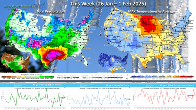
This week (26 Jan - 1 Feb) shows the U.S. trending -7.1F colder than last year and 19th coldest of the past 40 years. Snowfall up +225% vs last year but 11th least of the past 40 years, while rainfall is also down -13% but still 13th wettest of the past 39 years. FINALLY, some rain for California that should be enough to put out all of the wildfires.

And the biggest snowstorm of the season for this highest elevations of the Southwest. 6-day snowfall trends show +152% more snow than last year but still 9th least of the past 40 years with 30% of the U.S. population getting some snow. Colder weather at this point in the season is a negative for overall retail sales and store traffic.

Next week (2-8 Feb) shows the Polar Vortex starting to invade the U.S. from West to East. National temperatures trend -11.8F colder than last year, coldest in 11 years and 10th coldest of the past 40 years Exceptional sales gains for the must have Winter seasonal items in every region except the Southeast. A stormy pattern looks to be setting up with snowfall up +435% over last year, most in 11 years and 5th most of the past 40 years. Rainfall up +95%, most in 39 years and 2nd most in 40 years. This is a big store traffic disrupting pattern.
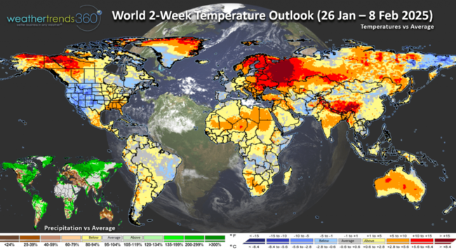 The World 2-week outlook (26 Jan - 8 Feb) shows the Western U.S. getting a big surge in seasonal sales demand and linger cold conditions in New England. It remains warm across Central and Eastern Europe and much of Asia.
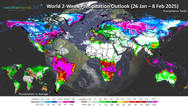
World 2-week precipitation (26 Jan - 8 Feb) shows a very storm pattern across the U.S., Eastern Canada, Western Europe and much of Brazil.
Have a great week, and don't forget to follow us on social media for frequent updates: Facebook, Twitter, YouTube, Pinterest and Linkedin.
- Captain Kirk out
For our FarmCast® clients, look for your 2025 U.S. and Global Ag outlook in your email on Monday. We have some good news for you. CLICK ON IMAGES FOR A LARGER VIEW.

U.S. snowfall season-to-date picked up some ground with the historic Deep South snowstorm. U.S. overall now +4% more snow than last year but still 6th least of the past 40 years.
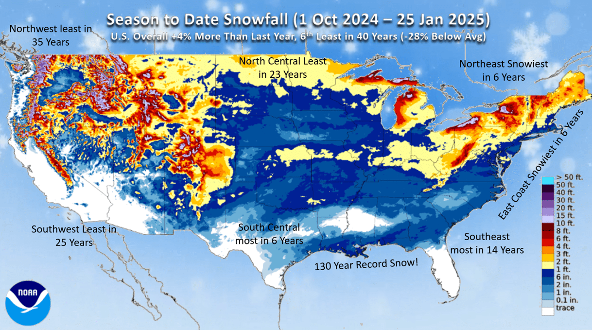
U.S. snow cover this morning stands at 37% vs 42% last year. An average year is around 41%, but the snow lingers across Louisiana to North Carolina.

Regional snowfall trends season-t0-date show the Southeast the biggest winner with +234% more snow than last year, Northeast +47% more than last year and the South Central +29% more. The biggest declines are in the West with the Southwest down -78% and the Northwest down -77%, while the North Central is down -23%.
U.S. weekly snowfall trends show an uptick in snowy weeks ahead as we transition into what looks like a very storm February. 2-week snowfall trends show +438% more than last year, most in 4 years and 10th most in 40 years for the U.S. overall.
World season-to-date snowfall shows a much snowier Winter across Central Canada, Eastern U.S. and Siberia.
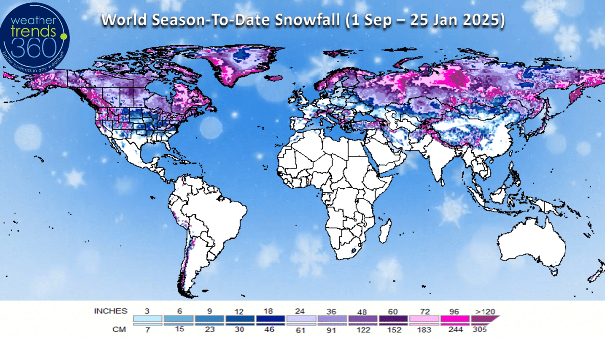
Much less snow across the Central U.S. and West and dramatically less across Europe.

Ocean temperature trends vs last year show a very clear weak La Nina like trend, but it appears this one will be short lived.
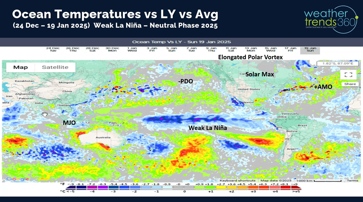
Looking below the surface of the Equatorial Pacific Ocean shows very warm waters West of Hawaii and even some warming near the surface off Ecuador.

Model guidance suggests we're headed for a neutral phase in the Pacific for the first time in 8 years.

Flu has peaked and now a 2-week decline after a much later start to the season this year.

The Polar Vortex is finally retreating as we enter a somewhat typical January Thaw.

But, all signs suggest it will come roaring back in early and middle February. The Western U.S. likely to get their coldest temperatures of the season in early February.

Last week (19-25 Jan) across the World shows the heart of the Polar Vortex over the U.S. with national temperatures trending a very significant -11.6F colder than last year and #1 coldest in over 40 years. It was -81% drier than last year, driest in 11 years and 5th driest of the past 40 years, while snowfall was +66% more than last year and 18th most of the past 40 years. These were exceptional trends for must have consumable Winter seasonal categories like Auto Batteries, Snow Accessories, Warm Beverages, etc. Europe was the warmest in 17 years while China was near record warm.
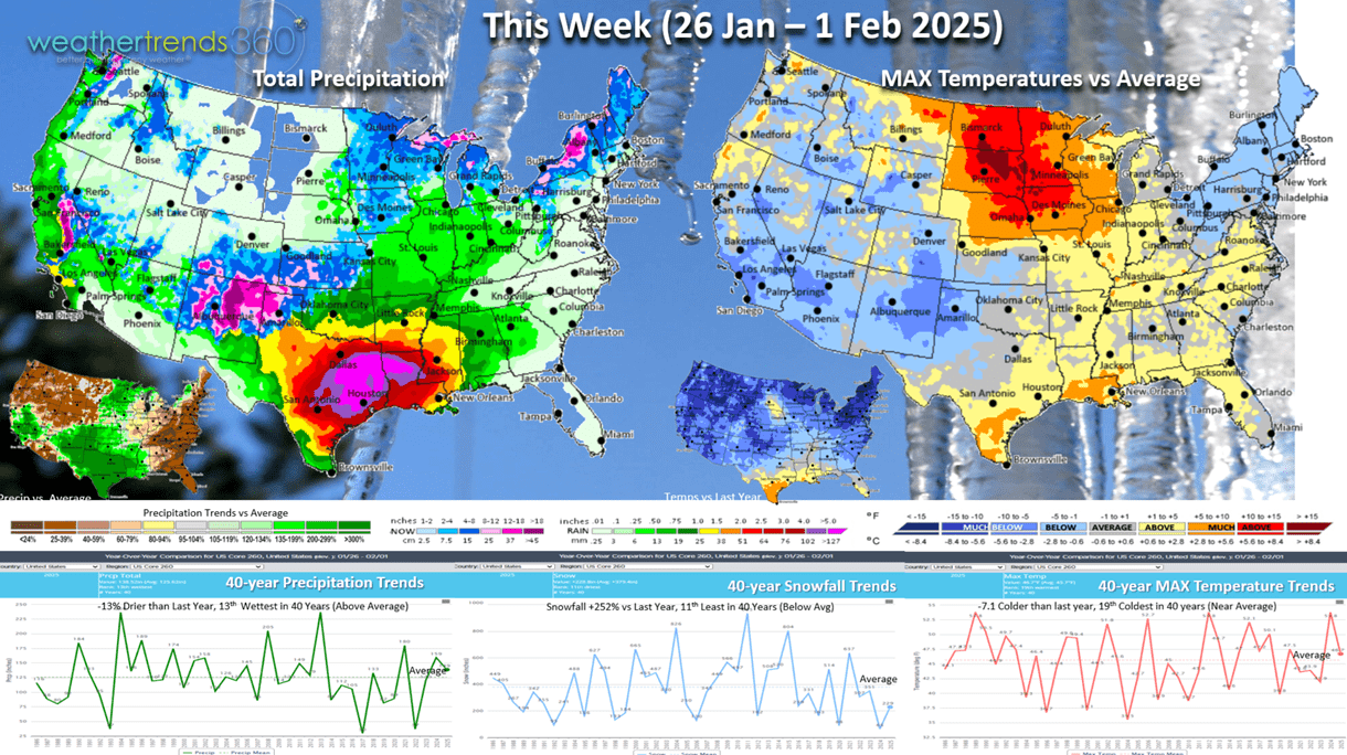
This week (26 Jan - 1 Feb) shows the U.S. trending -7.1F colder than last year and 19th coldest of the past 40 years. Snowfall up +225% vs last year but 11th least of the past 40 years, while rainfall is also down -13% but still 13th wettest of the past 39 years. FINALLY, some rain for California that should be enough to put out all of the wildfires.
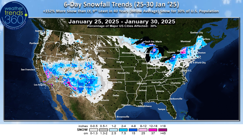
And the biggest snowstorm of the season for this highest elevations of the Southwest. 6-day snowfall trends show +152% more snow than last year but still 9th least of the past 40 years with 30% of the U.S. population getting some snow. Colder weather at this point in the season is a negative for overall retail sales and store traffic.
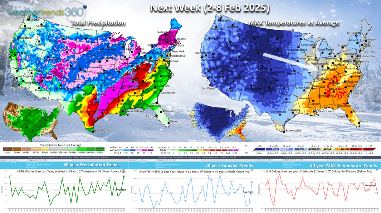
Next week (2-8 Feb) shows the Polar Vortex starting to invade the U.S. from West to East. National temperatures trend -11.8F colder than last year, coldest in 11 years and 10th coldest of the past 40 years Exceptional sales gains for the must have Winter seasonal items in every region except the Southeast. A stormy pattern looks to be setting up with snowfall up +435% over last year, most in 11 years and 5th most of the past 40 years. Rainfall up +95%, most in 39 years and 2nd most in 40 years. This is a big store traffic disrupting pattern.
 The World 2-week outlook (26 Jan - 8 Feb) shows the Western U.S. getting a big surge in seasonal sales demand and linger cold conditions in New England. It remains warm across Central and Eastern Europe and much of Asia.
World 2-week precipitation (26 Jan - 8 Feb) shows a very storm pattern across the U.S., Eastern Canada, Western Europe and much of Brazil.
Have a great week, and don't forget to follow us on social media for frequent updates: Facebook, Twitter, YouTube, Pinterest and Linkedin.
- Captain Kirk out