24 Jan '26 wt360 Weather Brief - Historic Cold & Snow to end Q4
Captain's Log
24 Jan '26: Happy Saturday! :)
Not sure what it is about late January, but historically we've had some huge snowstorms this week. Our biggest ever was 23 January 2016 with 31.8" and 2nd biggest 28.6" on 1 February 2021. The pending storm has a lot of similarities, so the upside could surprise folks. CLICK ON IMAGES FOR A LARGER VIEW.

team360 is BORN READY and have Plan A, B, C, and D snow removal strategies ready. Hopeful to keep this one in the snowblower range, but if we go into the I can't find my car mode, we'll call the neighbor who saved the day back in 2016 and 2021 with his huge front end loader. :)

The unusual aspect of this storm is just how widespread it will be from Texas to Maine, and the total U.S. snowfall index is off the charts and most in 50 years impacting 10s of millions of people. The ice storm on the southern fringe of the storm will likely lead to millions without power with the coldest late January weather in over 50 years.
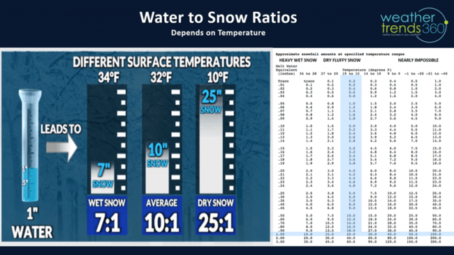
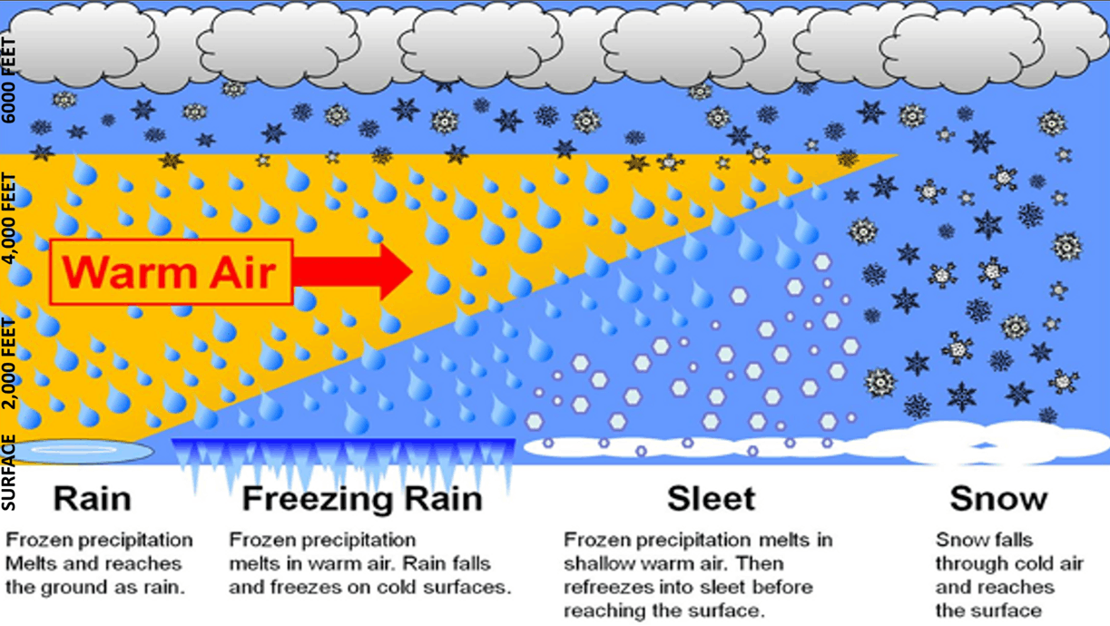
The other unusual aspect of this storm is the very cold conditions in the Northeast that will make this the fine powder snow vs the wet variety. It's one big factor in trying to predict the snow totals as 1" of liquid (models are showing many areas in the snow zone with 1 to 1.3" of LIQUID EQUIVALENT storm amounts which translate to very different snow totals depending on temperature. If this was a 32F event we'd have snow ratios closer to 10" of snow for every 1" of liquid, but at 15F for many that ratio jumps to 20" of snow for every 1" of liquid, this is referred to as the Kuchera affect. wt360 HQ is in the bullseye zone with 1.25" of liquid at 15F suggesting a max total of 25", models actually suggesting 10-15" with the threat for some sleet holding totals down a bit.
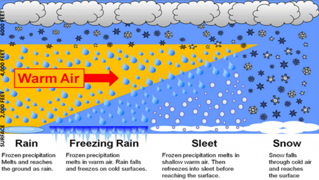
The other unknown with these classic "Miller B" snowstorms that jump from the Appalachians and redevelop off the East Coast into a Nor'easter is how far an upper level warm layer advances. That depends on how quickly the coastal storm develops. The thickness of that warm layer determines if you get all snow, some mixed sleet or freezing rain. The Virginia to Southern PA to Southern New Jersey have a higher likelihood of sleet mixing in and holding down snow totals, while 100 miles North remains all heavy snow.
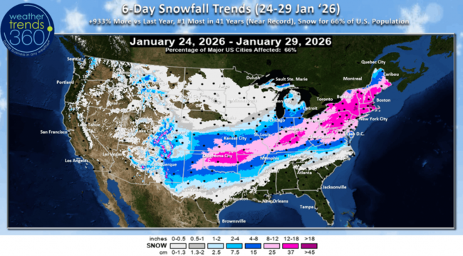
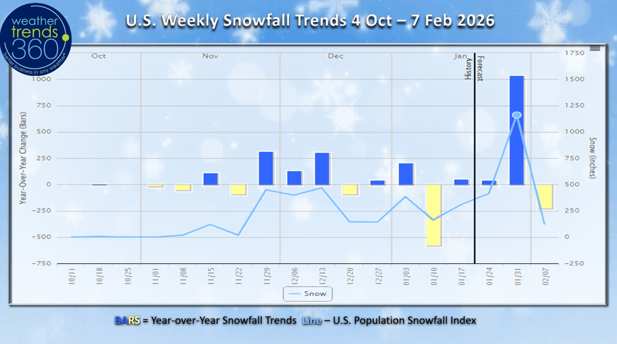
The official 6-day snow totals show the U.S. overall trending +933% more than last year and #1 most in over 50 years with 66% of the U.S. population getting some snow. This will be very disruptive to the end of Q1 into early Q2.
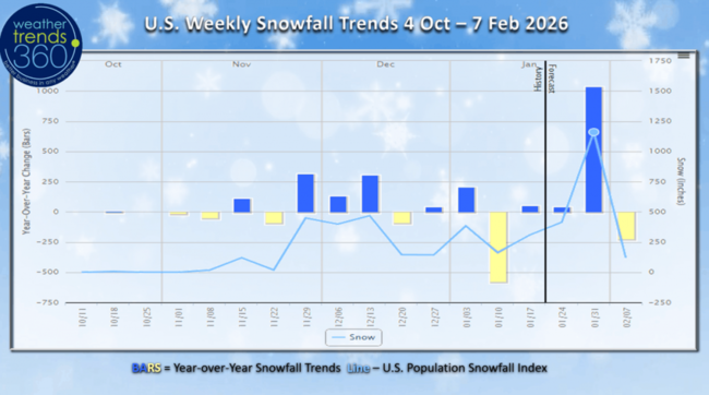
The U.S. weekly snowfall trends show this week ending 31 January with off the chart snow totals, the most WEEKLY SNOWFALL FOR THE U.S. OVERALL since early February 2021.
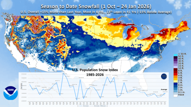
Season-to-date snowfall before this storm is trending +15% more than last year, most in 6 years, but this will jump to the most in 10 years after the storm.

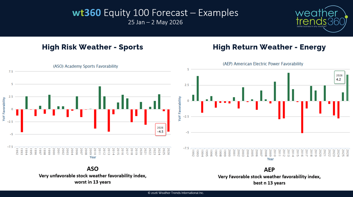
We had a call with one of our Financial Services clients highlighting some of our new AI forecasts. With our coldest and snowiest in 13 years Spring Q1 forecast, not surprising to see Academy Sports (ASO) equity weather favorability trending the worst in 13 years, but American Electric Power (AEP) trending the most favorable for stock performance in 13 years. Both have a similar Northeast footprint.
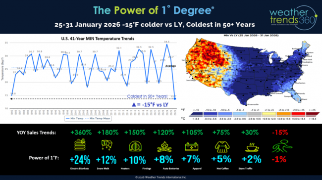
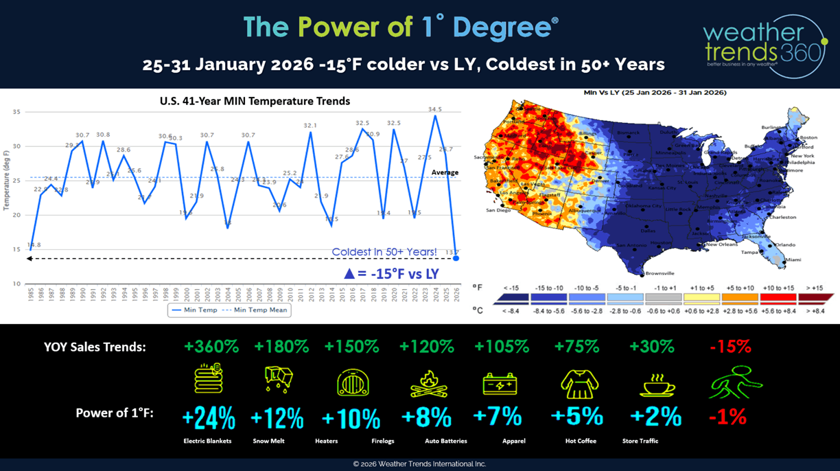
We also showed how our Power of 1 Degree technology quantifies weather's influence on sales using this last brutally cold/snowy week of Q1 as an example. Great for must have Winter clearance items, very poor for in-store traffic.
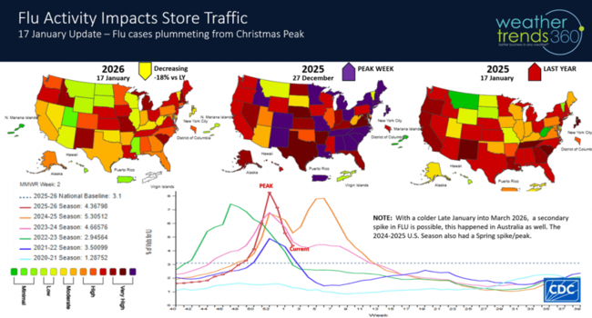
Flu is always an external factor that impacts store traffic and fortunately that's plummeting from the late December peak. But, with more cold and snow ahead, we could see a secondary spike in March, similar to what happened in Australia during their Winter last year.
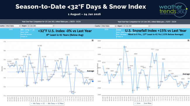
The U.S. cold index is trending flat to last year, but this will see a big uptick in cold 32F days next week after this Polar Vortex blast impacting the Eastern half of the U.S.
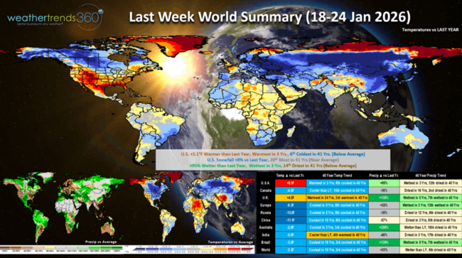
Last week (18-24 Jan) across the World showed the Polar Vortex starting to invade the U.S. but overall, it was still +5.1F warmer than last year, warmest in 3 years and 6th coldest of the past 41 years. Ironically the past two years we had brutally cold Polar Vortex outbreaks this week, so this year wasn't as cold and likely resulted in lower YOY sales for seasonal items. Those sales were certainly shifted to this last week of Q4 (25-31 Jan). Snowfall was up +8% YOY with rainfall also the most in 3 years. This time of year, warmer/drier is better for almost all retail outlets, benefiting store traffic. Other than the U.K. most major areas experience a much colder week than a year ago.
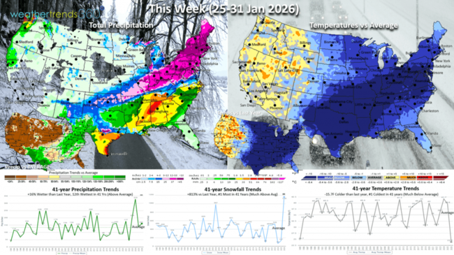
This week (25-31 Jan) is the end of Q4 for most retailers, and it will be extremely disruptive with lost sales due to the ice and snow storm. The U.S. trends #1 coldest in over 50 years (going back to 1970s), #1 snowiest and wetter than a year ago. The West continues to be the warm/dry spot favoring outdoor activities and overall store traffic.
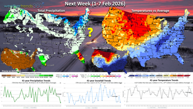
Next week (1-7 Feb) starts Q1 and there is some moderation, but the East remains the colder spot. Some questions with models on another potential storm event toward the weekend - TBD. The U.S. overall trends -6.2F colder than last year, coldest in 3 years and 15th coldest of the past 41 years - net negative for store traffic and sales. Snowfall down but again this could change and rainfall the #1 driest in over 41 years.

The World 2-week Temperature outlook (25 Jan - 7 Feb) shows the same general them of cold Eastern U.S., warm West and same footprint across Europe of warm West, cold East.

The World 2-week Precipitation outlook (25 Jan - 7 Feb) shows very wet across Brazil with near record crop yields expected in the weeks and months ahead. This will put more price pressure on commodities like Corn. Very stormy across Europe.
Have a great week ahead, and don't forget to follow us on social media for updates: Facebook, Twitter(X), YouTube, Pinterest and Linkedin.
- Captain Kirk out (USAF Gulf War Veteran 1989-1999)
Not sure what it is about late January, but historically we've had some huge snowstorms this week. Our biggest ever was 23 January 2016 with 31.8" and 2nd biggest 28.6" on 1 February 2021. The pending storm has a lot of similarities, so the upside could surprise folks. CLICK ON IMAGES FOR A LARGER VIEW.
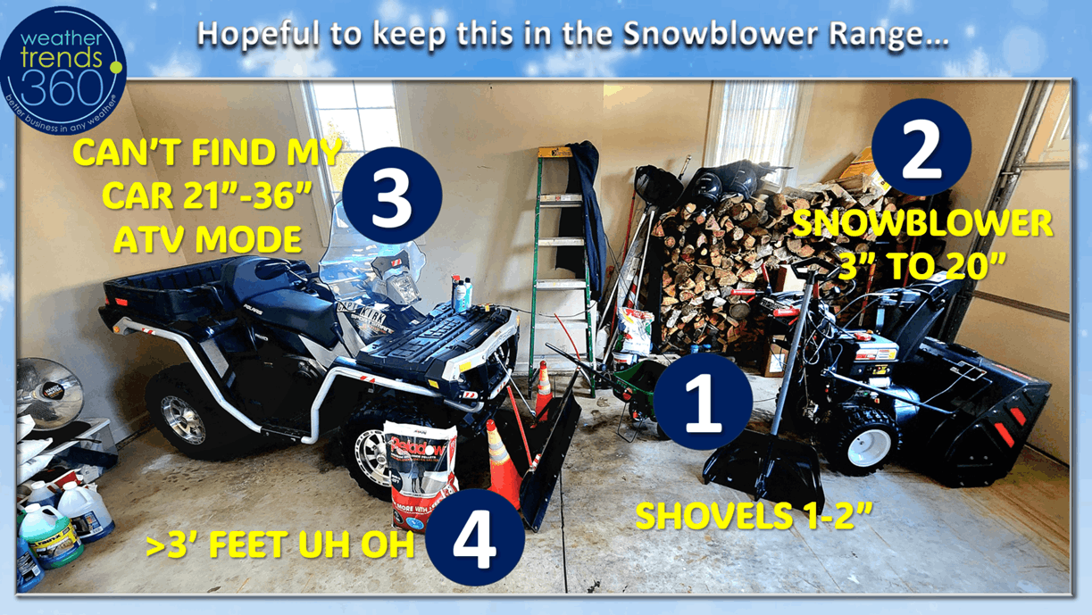
team360 is BORN READY and have Plan A, B, C, and D snow removal strategies ready. Hopeful to keep this one in the snowblower range, but if we go into the I can't find my car mode, we'll call the neighbor who saved the day back in 2016 and 2021 with his huge front end loader. :)

The unusual aspect of this storm is just how widespread it will be from Texas to Maine, and the total U.S. snowfall index is off the charts and most in 50 years impacting 10s of millions of people. The ice storm on the southern fringe of the storm will likely lead to millions without power with the coldest late January weather in over 50 years.

The other unusual aspect of this storm is the very cold conditions in the Northeast that will make this the fine powder snow vs the wet variety. It's one big factor in trying to predict the snow totals as 1" of liquid (models are showing many areas in the snow zone with 1 to 1.3" of LIQUID EQUIVALENT storm amounts which translate to very different snow totals depending on temperature. If this was a 32F event we'd have snow ratios closer to 10" of snow for every 1" of liquid, but at 15F for many that ratio jumps to 20" of snow for every 1" of liquid, this is referred to as the Kuchera affect. wt360 HQ is in the bullseye zone with 1.25" of liquid at 15F suggesting a max total of 25", models actually suggesting 10-15" with the threat for some sleet holding totals down a bit.
The other unknown with these classic "Miller B" snowstorms that jump from the Appalachians and redevelop off the East Coast into a Nor'easter is how far an upper level warm layer advances. That depends on how quickly the coastal storm develops. The thickness of that warm layer determines if you get all snow, some mixed sleet or freezing rain. The Virginia to Southern PA to Southern New Jersey have a higher likelihood of sleet mixing in and holding down snow totals, while 100 miles North remains all heavy snow.

The official 6-day snow totals show the U.S. overall trending +933% more than last year and #1 most in over 50 years with 66% of the U.S. population getting some snow. This will be very disruptive to the end of Q1 into early Q2.
The U.S. weekly snowfall trends show this week ending 31 January with off the chart snow totals, the most WEEKLY SNOWFALL FOR THE U.S. OVERALL since early February 2021.

Season-to-date snowfall before this storm is trending +15% more than last year, most in 6 years, but this will jump to the most in 10 years after the storm.
We had a call with one of our Financial Services clients highlighting some of our new AI forecasts. With our coldest and snowiest in 13 years Spring Q1 forecast, not surprising to see Academy Sports (ASO) equity weather favorability trending the worst in 13 years, but American Electric Power (AEP) trending the most favorable for stock performance in 13 years. Both have a similar Northeast footprint.
We also showed how our Power of 1 Degree technology quantifies weather's influence on sales using this last brutally cold/snowy week of Q1 as an example. Great for must have Winter clearance items, very poor for in-store traffic.

Flu is always an external factor that impacts store traffic and fortunately that's plummeting from the late December peak. But, with more cold and snow ahead, we could see a secondary spike in March, similar to what happened in Australia during their Winter last year.

The U.S. cold index is trending flat to last year, but this will see a big uptick in cold 32F days next week after this Polar Vortex blast impacting the Eastern half of the U.S.

Last week (18-24 Jan) across the World showed the Polar Vortex starting to invade the U.S. but overall, it was still +5.1F warmer than last year, warmest in 3 years and 6th coldest of the past 41 years. Ironically the past two years we had brutally cold Polar Vortex outbreaks this week, so this year wasn't as cold and likely resulted in lower YOY sales for seasonal items. Those sales were certainly shifted to this last week of Q4 (25-31 Jan). Snowfall was up +8% YOY with rainfall also the most in 3 years. This time of year, warmer/drier is better for almost all retail outlets, benefiting store traffic. Other than the U.K. most major areas experience a much colder week than a year ago.
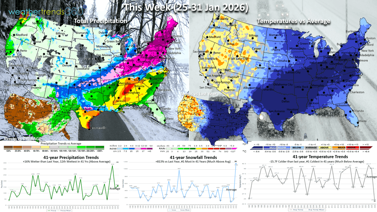
This week (25-31 Jan) is the end of Q4 for most retailers, and it will be extremely disruptive with lost sales due to the ice and snow storm. The U.S. trends #1 coldest in over 50 years (going back to 1970s), #1 snowiest and wetter than a year ago. The West continues to be the warm/dry spot favoring outdoor activities and overall store traffic.

Next week (1-7 Feb) starts Q1 and there is some moderation, but the East remains the colder spot. Some questions with models on another potential storm event toward the weekend - TBD. The U.S. overall trends -6.2F colder than last year, coldest in 3 years and 15th coldest of the past 41 years - net negative for store traffic and sales. Snowfall down but again this could change and rainfall the #1 driest in over 41 years.
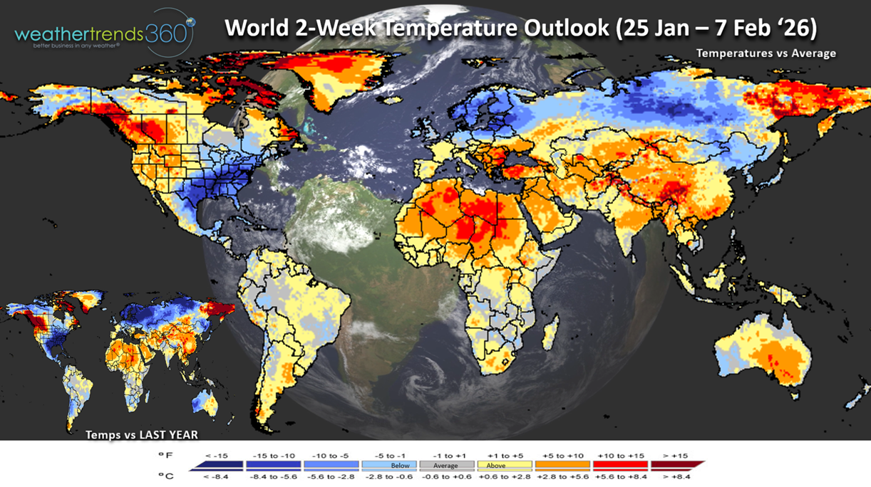
The World 2-week Temperature outlook (25 Jan - 7 Feb) shows the same general them of cold Eastern U.S., warm West and same footprint across Europe of warm West, cold East.
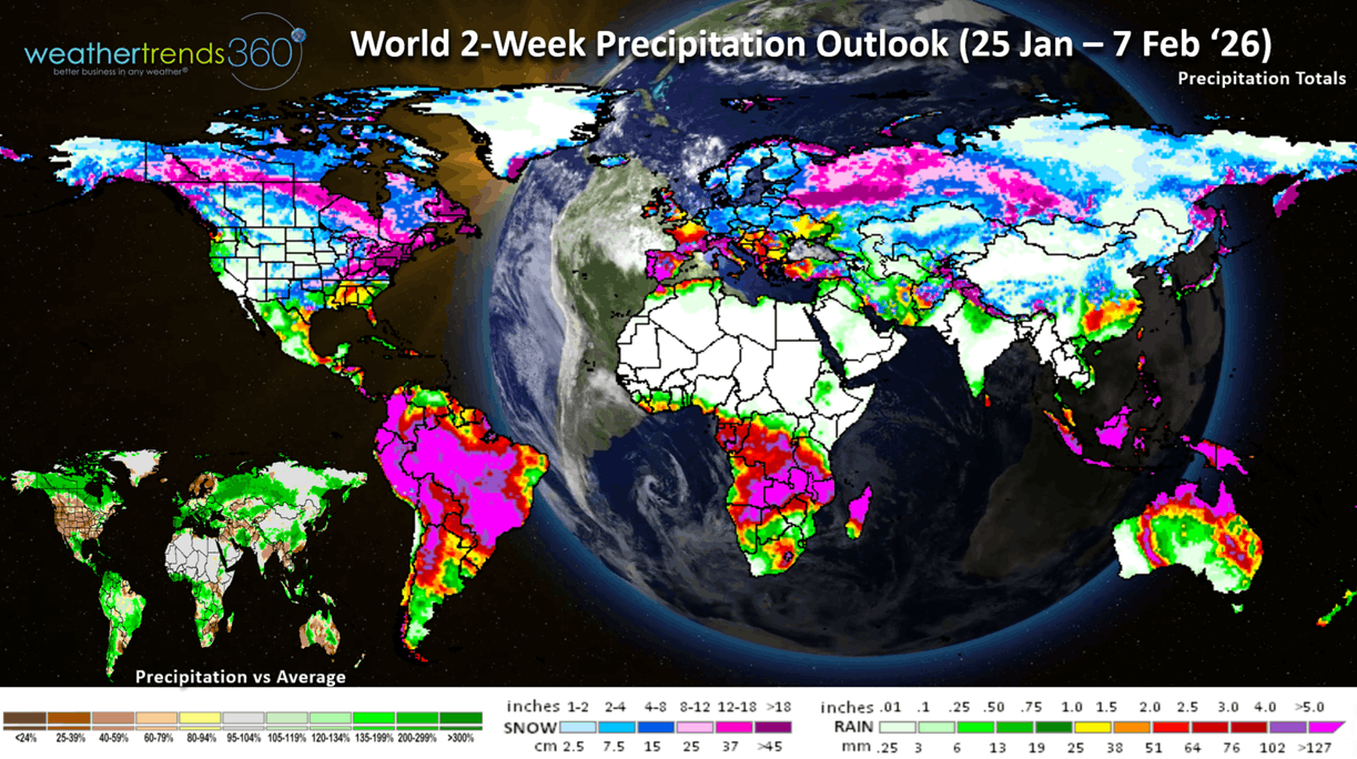
The World 2-week Precipitation outlook (25 Jan - 7 Feb) shows very wet across Brazil with near record crop yields expected in the weeks and months ahead. This will put more price pressure on commodities like Corn. Very stormy across Europe.
Have a great week ahead, and don't forget to follow us on social media for updates: Facebook, Twitter(X), YouTube, Pinterest and Linkedin.
- Captain Kirk out (USAF Gulf War Veteran 1989-1999)