21 Feb '26 wt360 Weather Brief - Winter East, Spring West
Captain's Log
21 Feb '26: Happy Saturday! :)
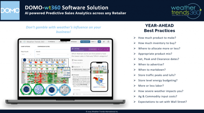
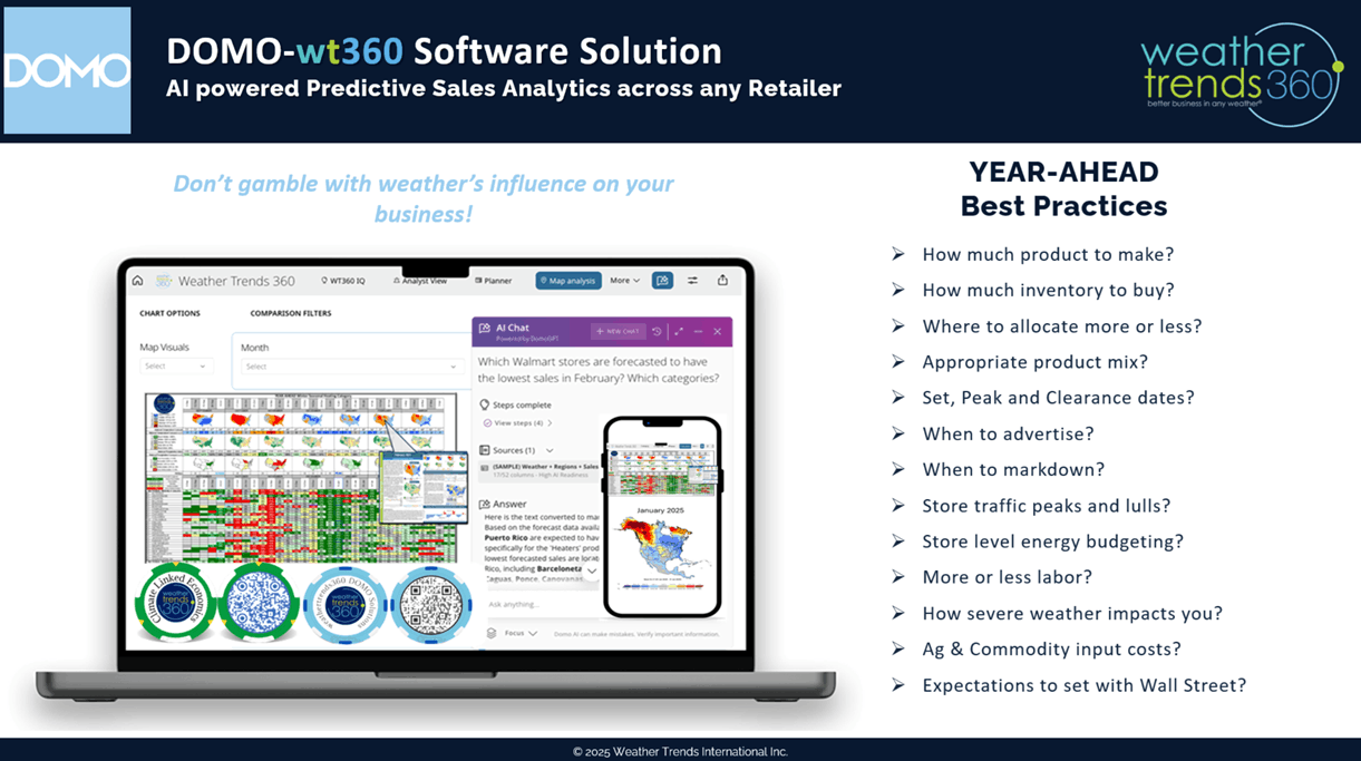
We are honored to sponsor DOMO'Palooza 24-27 March again this year and there's still time to register for this world class AI data conference.

We have super cool predictive AI software in the DOMO environment to help retailers and seasonal suppliers predict seasonal sales week-by-week, by store/warehouse out a year! CLICK ON IMAGES FOR A LARGER VIEW.
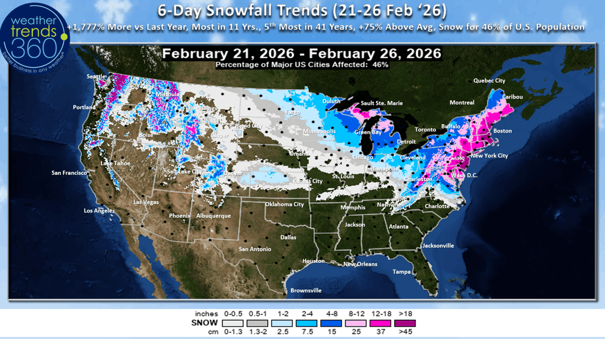
Now the big question everyone wants to know is how much snow will this major Nor'easter blizzard bring to the Northeast from Virginia to Maine? A LOT. It's a classic heavy wet snow Nor'easter that will bring widespread 1-2 feet amounts. As with any intense storm there are several components that can diminish or enhance those totals to include: 1) dry air intrusion can create dry slots where the snow shuts down for hours or completely. 2) back-end frontogenesis can create another area (northwest portion of storm) where snow trains over the same area dramatically boosting totals and 3) super intense storms can pull the snow bands closer to the core and 4) daytime starting events can bring a mix of rain and snow for hours at the onset diminishing totals until after dark. That said, 60 million people are about to get dumped on Sunday-Monday.
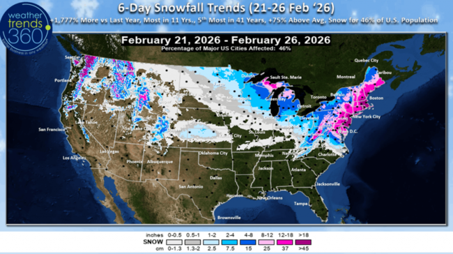
6-day snowfall forecast (21-26 Feb) shows 46% of the U.S. population getting some snow, the U.S. overall trending +1,777% more than last year, most in 11 years and 5th most in 41 years (+75% above average). Snow in the West is beginning to wind down.

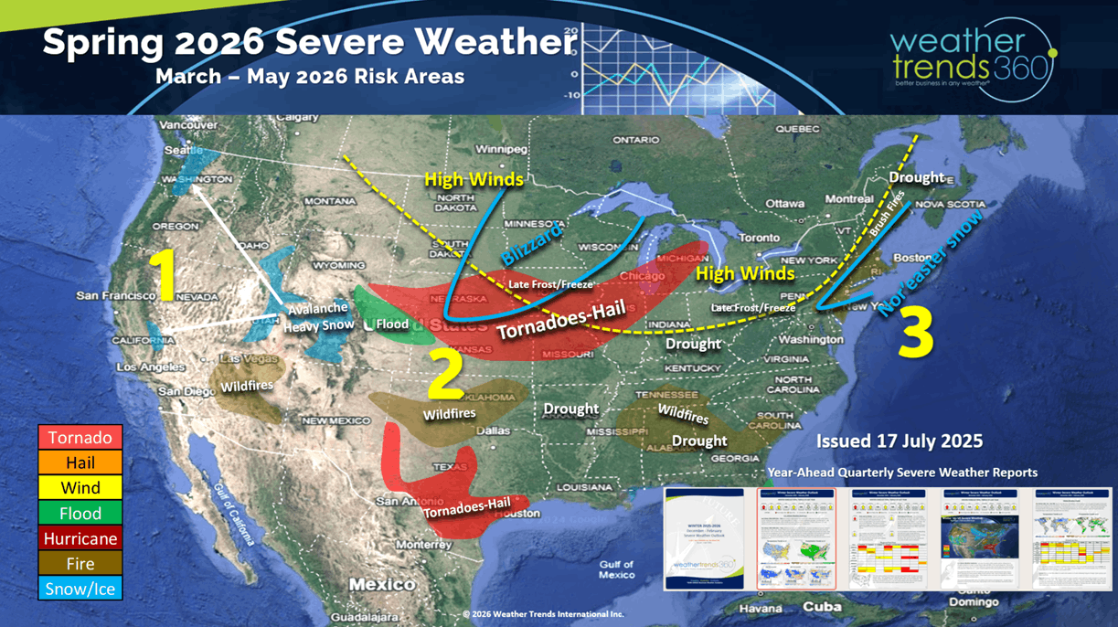
The wt360 predictive AI question of the week...tell me about Spring 2026 severe weather. Kind of amazing that our year-ahead outlook issued last July has already predicted 3 major events: 1) the Avalanche in California, 2) wildfire in Oklahoma and 3) Nor'easter. Sadly more of all 3 likely for early Spring.

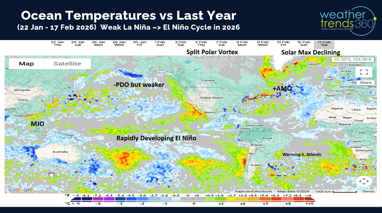
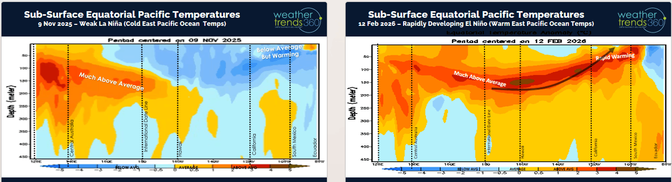
The big transition to El Niño is developing quickly by mid to late Spring.
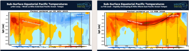
This is confirmed by the rapid warming of the sub-surface Equatorial Ocean temperatures. Chart left shows the cold ocean temps back in November and chart right the rapid warming as of middle February. This will have sweeping changes to both North America and South America with a much wetter pattern ahead and reduced tropical activity this Summer.
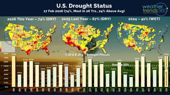
While 74% of the U.S. is still in dry to drought phases, this will plummet to just 44% by Summer and especially Fall. The prolonged pattern of La Niñas (cold Equatorial Pacific) is one major factor contributing to the multi-year drought in the U.S., this is changing with Brazil already transitioned to a very wet pattern, U.S. is next!
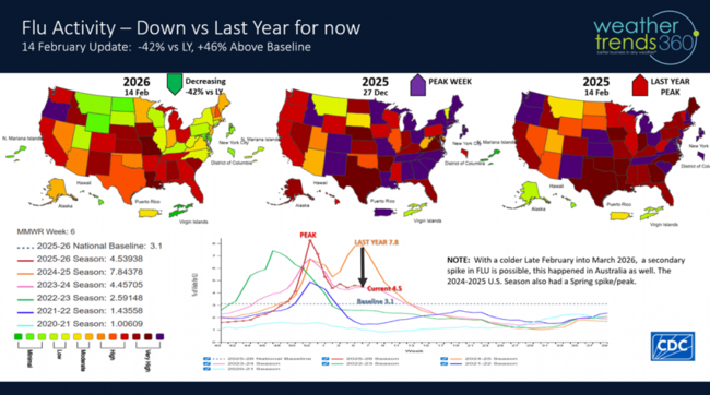
Flu activity remained relatively flat to the last update. Still a chance of a secondary spike, but we're down -42% from last year at this point which benefits store traffic.
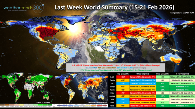
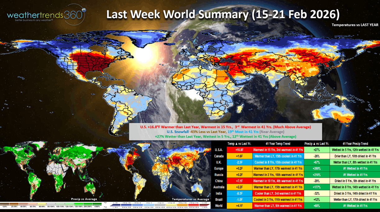
Last week (15-21 Feb) across the World shows the big February Thaw in the U.S. trending +16.8F warmer than last year, warmest in 15 years and 3rd warmest in 41 years, a huge plus for store traffic. But it was also +27% wetter than a year ago, most in 5 years and 12th most in 41 years, which is a negative for store traffic. Snowfall was down -43% vs LY, but still 19th most in 41 years (near average). This time of year, warm/dry is the most ideal for store traffic and seasonal sales, so the South Central was a bright spot as was Northeast China. The Europe was #1 wettest in 41 years, a negative.
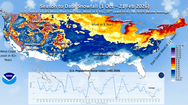
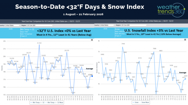
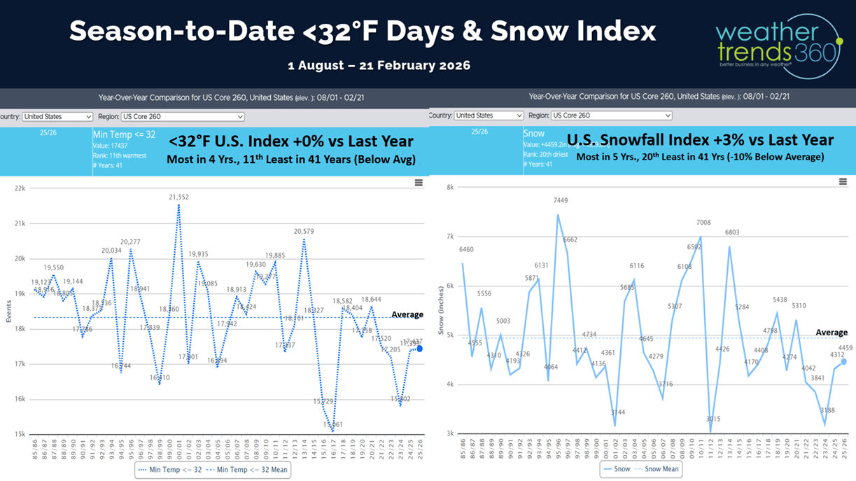
Snowfall season-to-date shows the U.S. trending +3.4% more than last year, most in 5 years and 20th least in 41 years. This will increase after the blizzard.
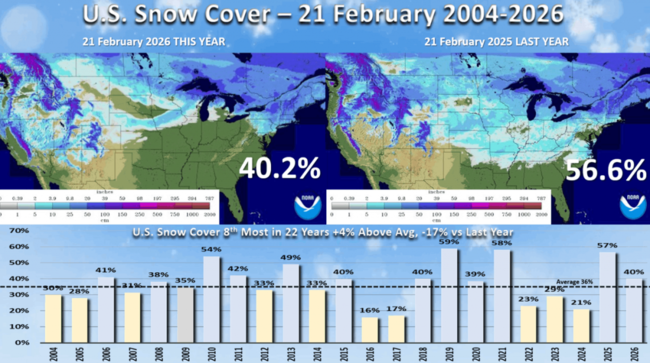
Snow Cover as of 21 Feb was at 40.2% of the U.S. with snow on the ground vs 56.6% las year and average 36%.
Cold less than 32F days across the U.S. are up a fraction of a percent and the most in 4 years, but still 11th least in 41 years for the U.S. overall.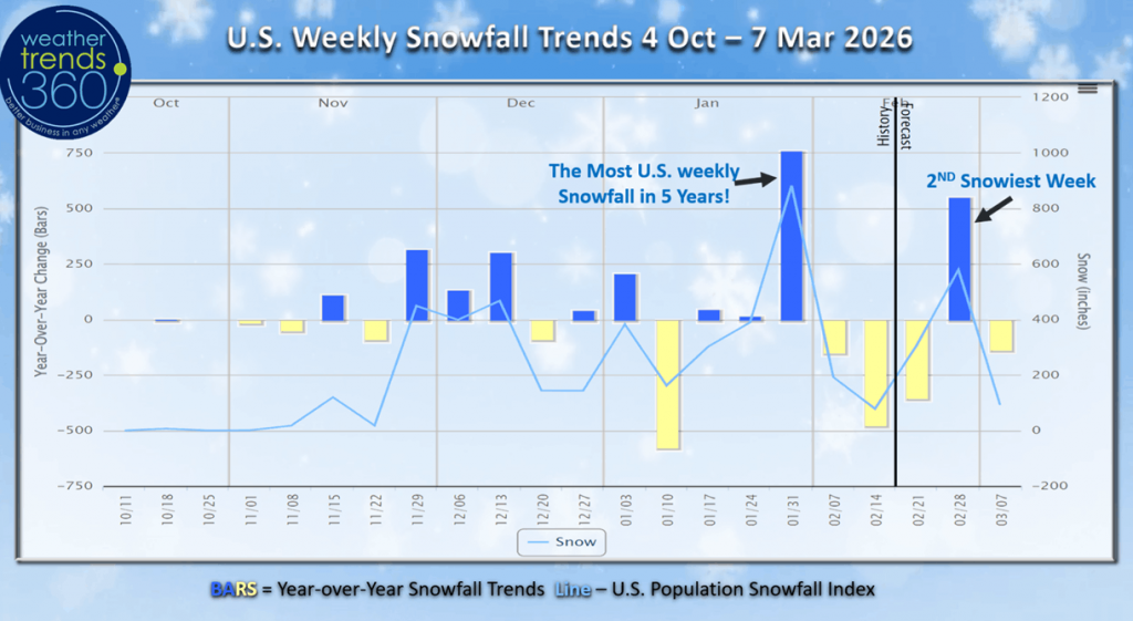 Weekly snowfall trends shows this big Nor'easter will end up making the last week of February the 2nd snowiest week of Winter. The peak week was in late January which brought the most snow to the U.S. for any Winter week going back 5 years.

Short range models have really struggled with this pending blizzard but with the overall pattern as well. In part because the Polar Vortex is weak and elongated which can make it challenging to determine the exact timing of a series of cold snaps heading into the U.S. Expect models to get colder than forecast as we transition into March.
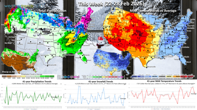
This week (22-28 Feb) is back to a tale of two halves (Winter East, Spring West) with the U.S. trending -7.5F colder than last year, coldest in 3 years but 13th warmest in 41 years nationally. Snowfall way up +1,312%, most in 15 years and 6th most in 41 years, while rainfall is up +126% over LY. These are very negative trends for Spring seasonal sales, but the West and Plains are certainly best.
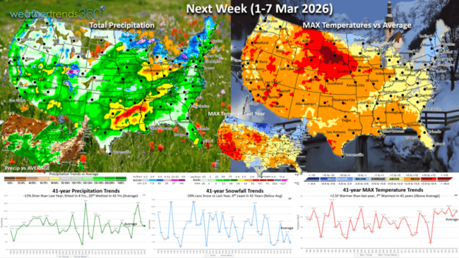
Next week (1-7 Mar) shows cold and snow hanging on in the Northeast, warm elsewhere, but we need to watch for this to trend colder than the current models are forecasting with a potential glancing shot of the Polar Vortex. The week overall currently trends +2.5F warmer than last year and 7th warmest of the past 41 years. Snowfall down -59% vs LY, with rainfall also down -13% and least in 4 years. These are generally favorable trends for store traffic, but again there is risk the East turns colder than forecast.

The World 2-week Temperature Outlook (22 Feb - 7 Mar) shows Eastern Canada, Eastern U.S. and Eastern Europe the least favorable areas with the Western parts of each country better for Spring merchandise.

The World 2-week Precipitation Outlook (22 Feb - 7 Mar) shows an overall stormy pattern in the Northeast U.S. but a dry Southeast and continued wet across most of Brazil's crop regions.

We will "Spring Ahead" Sunday 8 March as Daylight Savings Time starts.
You can get this blog/video in your email inbox every Saturday (FREE) via subscription.
Have a great week ahead, and don't forget to follow us on social media for updates: Facebook, Twitter(X), YouTube, Pinterest and Linkedin.
- Captain Kirk out (USAF Gulf War Veteran 1989-1999)
We are honored to sponsor DOMO'Palooza 24-27 March again this year and there's still time to register for this world class AI data conference.

We have super cool predictive AI software in the DOMO environment to help retailers and seasonal suppliers predict seasonal sales week-by-week, by store/warehouse out a year! CLICK ON IMAGES FOR A LARGER VIEW.
Now the big question everyone wants to know is how much snow will this major Nor'easter blizzard bring to the Northeast from Virginia to Maine? A LOT. It's a classic heavy wet snow Nor'easter that will bring widespread 1-2 feet amounts. As with any intense storm there are several components that can diminish or enhance those totals to include: 1) dry air intrusion can create dry slots where the snow shuts down for hours or completely. 2) back-end frontogenesis can create another area (northwest portion of storm) where snow trains over the same area dramatically boosting totals and 3) super intense storms can pull the snow bands closer to the core and 4) daytime starting events can bring a mix of rain and snow for hours at the onset diminishing totals until after dark. That said, 60 million people are about to get dumped on Sunday-Monday.
6-day snowfall forecast (21-26 Feb) shows 46% of the U.S. population getting some snow, the U.S. overall trending +1,777% more than last year, most in 11 years and 5th most in 41 years (+75% above average). Snow in the West is beginning to wind down.
The wt360 predictive AI question of the week...tell me about Spring 2026 severe weather. Kind of amazing that our year-ahead outlook issued last July has already predicted 3 major events: 1) the Avalanche in California, 2) wildfire in Oklahoma and 3) Nor'easter. Sadly more of all 3 likely for early Spring.
The big transition to El Niño is developing quickly by mid to late Spring.
This is confirmed by the rapid warming of the sub-surface Equatorial Ocean temperatures. Chart left shows the cold ocean temps back in November and chart right the rapid warming as of middle February. This will have sweeping changes to both North America and South America with a much wetter pattern ahead and reduced tropical activity this Summer.

While 74% of the U.S. is still in dry to drought phases, this will plummet to just 44% by Summer and especially Fall. The prolonged pattern of La Niñas (cold Equatorial Pacific) is one major factor contributing to the multi-year drought in the U.S., this is changing with Brazil already transitioned to a very wet pattern, U.S. is next!

Flu activity remained relatively flat to the last update. Still a chance of a secondary spike, but we're down -42% from last year at this point which benefits store traffic.
Last week (15-21 Feb) across the World shows the big February Thaw in the U.S. trending +16.8F warmer than last year, warmest in 15 years and 3rd warmest in 41 years, a huge plus for store traffic. But it was also +27% wetter than a year ago, most in 5 years and 12th most in 41 years, which is a negative for store traffic. Snowfall was down -43% vs LY, but still 19th most in 41 years (near average). This time of year, warm/dry is the most ideal for store traffic and seasonal sales, so the South Central was a bright spot as was Northeast China. The Europe was #1 wettest in 41 years, a negative.

Snowfall season-to-date shows the U.S. trending +3.4% more than last year, most in 5 years and 20th least in 41 years. This will increase after the blizzard.

Snow Cover as of 21 Feb was at 40.2% of the U.S. with snow on the ground vs 56.6% las year and average 36%.
Cold less than 32F days across the U.S. are up a fraction of a percent and the most in 4 years, but still 11th least in 41 years for the U.S. overall.
Weekly snowfall trends shows this big Nor'easter will end up making the last week of February the 2nd snowiest week of Winter. The peak week was in late January which brought the most snow to the U.S. for any Winter week going back 5 years.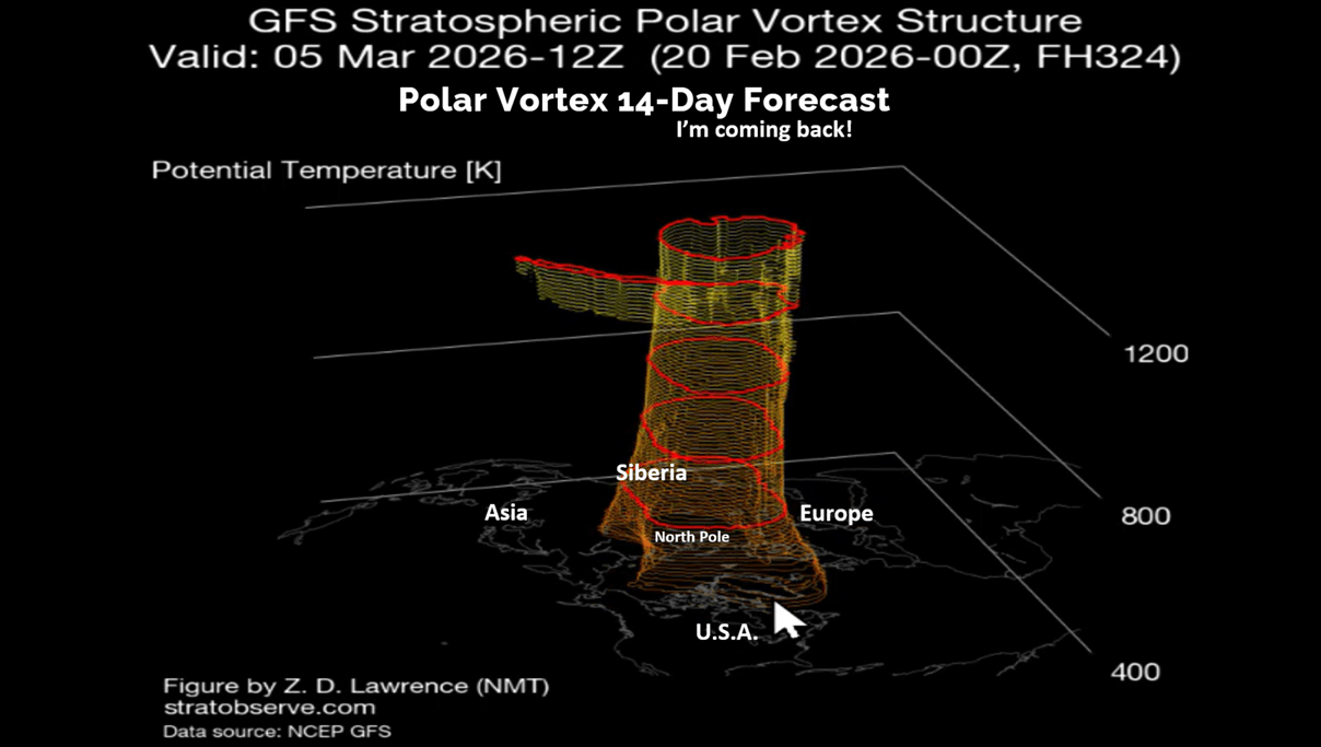
Short range models have really struggled with this pending blizzard but with the overall pattern as well. In part because the Polar Vortex is weak and elongated which can make it challenging to determine the exact timing of a series of cold snaps heading into the U.S. Expect models to get colder than forecast as we transition into March.

This week (22-28 Feb) is back to a tale of two halves (Winter East, Spring West) with the U.S. trending -7.5F colder than last year, coldest in 3 years but 13th warmest in 41 years nationally. Snowfall way up +1,312%, most in 15 years and 6th most in 41 years, while rainfall is up +126% over LY. These are very negative trends for Spring seasonal sales, but the West and Plains are certainly best.

Next week (1-7 Mar) shows cold and snow hanging on in the Northeast, warm elsewhere, but we need to watch for this to trend colder than the current models are forecasting with a potential glancing shot of the Polar Vortex. The week overall currently trends +2.5F warmer than last year and 7th warmest of the past 41 years. Snowfall down -59% vs LY, with rainfall also down -13% and least in 4 years. These are generally favorable trends for store traffic, but again there is risk the East turns colder than forecast.
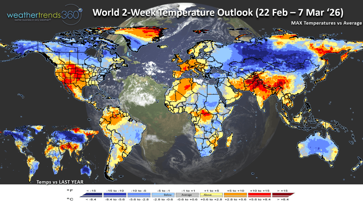
The World 2-week Temperature Outlook (22 Feb - 7 Mar) shows Eastern Canada, Eastern U.S. and Eastern Europe the least favorable areas with the Western parts of each country better for Spring merchandise.
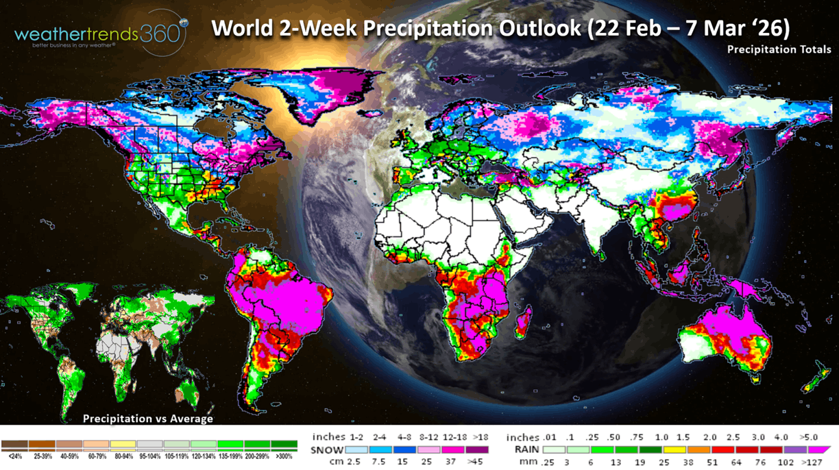
The World 2-week Precipitation Outlook (22 Feb - 7 Mar) shows an overall stormy pattern in the Northeast U.S. but a dry Southeast and continued wet across most of Brazil's crop regions.
We will "Spring Ahead" Sunday 8 March as Daylight Savings Time starts.
You can get this blog/video in your email inbox every Saturday (FREE) via subscription.
Have a great week ahead, and don't forget to follow us on social media for updates: Facebook, Twitter(X), YouTube, Pinterest and Linkedin.
- Captain Kirk out (USAF Gulf War Veteran 1989-1999)