2017 Outlook for Atlantic Hurricane Season
Business
It's hard to believe but in less than 3 weeks, the 2017 Atlantic Hurricane Season will officially begin. But the weather doesn't always keep to a strict schedule as we've already seen the first tropical storm of the season. Tropical Storm Arlene, which developed far out in the Atlantic in April, was only the 2nd April tropical storm since we began monitoring the oceans with satellites. Could the early development of Arlene be a harbinger of things to come? Read on to find out what our paying clients already knew a month ago about the upcoming Hurricane Season.
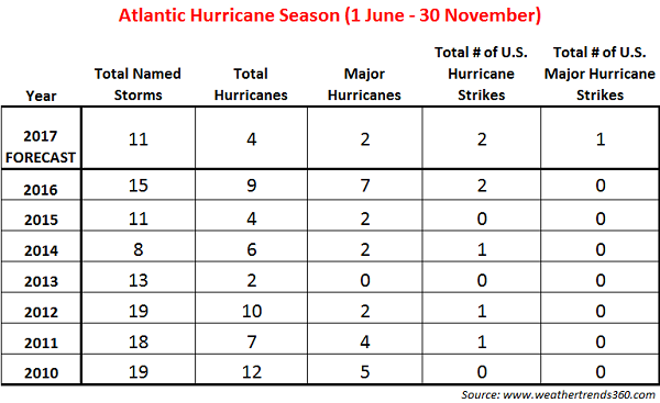
In 2016, we saw an uptick in tropical activity with 15 named storms following 3 years of near to below normal active seasons. In 2017, weathertrends360 expects tropical activity to take another dip with near to below normal activity.
The official forecast numbers from weathertrends360 are: 11 total named storms, 4 hurricanes, 2 major hurricanes (category 3 and above), 2 hurricane strikes in the U.S., and 1 major hurricane strike in the U.S.
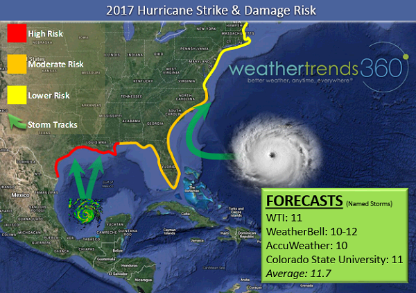
The greatest concern this year for a land-falling tropical system is along the western Gulf Coast, especially if a storm occurs in the early part of the season and catches people off-guard. While water temperatures in the western Gulf of Mexico have cooled in response to recent heavy rain and upwelling, we expect the warmer water temperatures to return. Warmer waters are one of the many ingredients needed to develop and strengthen tropical systems. Of particular concern will be the early to mid June period when a tropical system, or at least an area of disturbed weather, could move from the Bay of Campeche to the western Gulf of Mexico. Meanwhile, the East Coast should see a lower risk for major land-falling systems this season, however, there is the potential for very wet and possibly flooding conditions with any tropical system or remnants that nears the region.
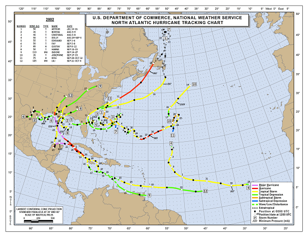
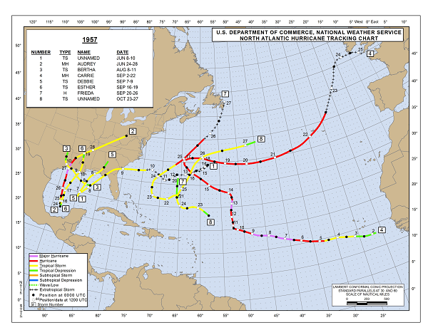
When compiling our forecast, we analyzed years with similar atmospheric and oceanic conditions to 2017 to help forecast patterns and tendencies of tropical systems this year. These similar years are 1957 and 2002, both of which featured a near or below normal number of storms in the Atlantic Basin (see storm track maps below for both seasons). The 1957 season featured land-falling Major Hurricane Audrey which was an early season Gulf of Mexico storm. The 2002 season also featured a land-falling Gulf of Mexico storm.
 One of the big unknowns of the upcoming season is whether or not an El Niño forms. During El Niño conditions, vertical wind shear increases over the Atlantic which makes the environment less favorable for storm development and strengthening. Forecasting models earlier this year had largely agreed on an El Niño forming late this summer, however, the forecasts have since backed off of that idea. Even if El Niño does not form, we still believe there will be an almost El Niño-esque pattern which would support lower activity in the Atlantic.
Despite the numbers and expected tracks, we want to remind you that it takes just one storm to cause a significant impact. If you live or work in hurricane-prone areas, please be prepared this, and every, hurricane season. When a storm threatens heed the advice of local emergency management. To stay a step ahead of the storm, check out our Interactive Maps where you can track storms using the "Tropical" overlay and view forecasts for the next 14 days. Be safe and be vigilant!
In 2016, we saw an uptick in tropical activity with 15 named storms following 3 years of near to below normal active seasons. In 2017, weathertrends360 expects tropical activity to take another dip with near to below normal activity.
The official forecast numbers from weathertrends360 are: 11 total named storms, 4 hurricanes, 2 major hurricanes (category 3 and above), 2 hurricane strikes in the U.S., and 1 major hurricane strike in the U.S.

The greatest concern this year for a land-falling tropical system is along the western Gulf Coast, especially if a storm occurs in the early part of the season and catches people off-guard. While water temperatures in the western Gulf of Mexico have cooled in response to recent heavy rain and upwelling, we expect the warmer water temperatures to return. Warmer waters are one of the many ingredients needed to develop and strengthen tropical systems. Of particular concern will be the early to mid June period when a tropical system, or at least an area of disturbed weather, could move from the Bay of Campeche to the western Gulf of Mexico. Meanwhile, the East Coast should see a lower risk for major land-falling systems this season, however, there is the potential for very wet and possibly flooding conditions with any tropical system or remnants that nears the region.

When compiling our forecast, we analyzed years with similar atmospheric and oceanic conditions to 2017 to help forecast patterns and tendencies of tropical systems this year. These similar years are 1957 and 2002, both of which featured a near or below normal number of storms in the Atlantic Basin (see storm track maps below for both seasons). The 1957 season featured land-falling Major Hurricane Audrey which was an early season Gulf of Mexico storm. The 2002 season also featured a land-falling Gulf of Mexico storm.

 One of the big unknowns of the upcoming season is whether or not an El Niño forms. During El Niño conditions, vertical wind shear increases over the Atlantic which makes the environment less favorable for storm development and strengthening. Forecasting models earlier this year had largely agreed on an El Niño forming late this summer, however, the forecasts have since backed off of that idea. Even if El Niño does not form, we still believe there will be an almost El Niño-esque pattern which would support lower activity in the Atlantic.
Despite the numbers and expected tracks, we want to remind you that it takes just one storm to cause a significant impact. If you live or work in hurricane-prone areas, please be prepared this, and every, hurricane season. When a storm threatens heed the advice of local emergency management. To stay a step ahead of the storm, check out our Interactive Maps where you can track storms using the "Tropical" overlay and view forecasts for the next 14 days. Be safe and be vigilant!