2017 Northern/Central California Flood
Scientific Meteorology
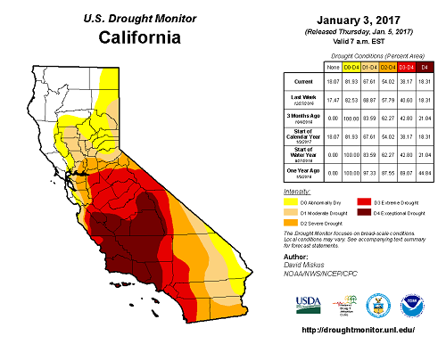
For years the desperate drought situation in California seems to have been the only weather-related headline coming out of the state. However, over the next week the headlines will change as California goes from dry to completely drenched. Actually, the soaking has already begun as an atmospheric river earlier this week brought copious amounts of moisture into central and northern California. Already we've seen several inches of rain and several feet of snow in the Sierras, but consider this event just an appetizer.
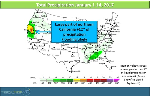
Next week more atmospheric moisture will move onshore from the Pacific with the potential for up to or even over a foot of rain and more feet of snow in the Sierras. At least two different storm systems are in the forecast for the next 7 days both packing a soggy punch.
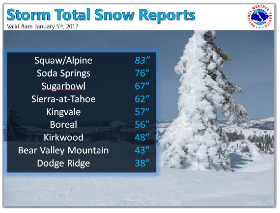
So far this week, several ski resorts in northern California have reported over 3' of new snow. The National Weather Service office put together a list of some of the reports, shown below:
More snow is forecast for the weekend as another storm system moves onshore starting Saturday with heavy snow in the Sierras, Cascades, and Northern Rocky Mountains. Snow and rain is in the forecast for almost every day next week as a prolonged wet pattern takes shape, the most significant amounts are expected through Monday, across northern California and in parts of central California.
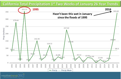
At the moment, the upcoming weekend's storm looks to be the strongest of the storms with the potential for more than a foot of rain in the Sierra Nevada and several feet of snow in the higher elevations, above 8,000 feet. Flooding is going to become a real problem across the region as recent rain combined with further bouts of heavy rain tax local waterways. Flooding could be the worst since December 2005 on some of the rivers in northern California. Looking at the precipitation totals for the first half of January, this year is on par with the first half of January 1995 (see chart below) when heavy rain caused major flooding in California. While no 2 weather events are ever exactly alike, it is imperative that folks in these areas heed the warnings and take action now to avoid disaster in the coming days. This will be a very significant event across central and northern California. Record flooding is possible in the upcoming week, starting this weekend.
If excessive rainfall wasn't bad enough, some of the snow that the region received earlier this week will melt as temperatures rise resulting in higher snow levels (the snow level is the lowest elevation at which snow occurs). This means that snow will be melting and running off into the rivers and valleys below enhancing the flood threat over the weekend. Again, we cannot stress enough that this will be a serious and dangerous situation.
Southern California will miss out on the excessive rain, but there will be some periods of rain in the region. We're still trying to get rid of a multi-year drought in California so the precipitation will definitely help to take a bite out of that. Drought conditions in northern California have been knocked down quite a bit over the past year but significant drought remains in central and southern California.

Next week more atmospheric moisture will move onshore from the Pacific with the potential for up to or even over a foot of rain and more feet of snow in the Sierras. At least two different storm systems are in the forecast for the next 7 days both packing a soggy punch.

So far this week, several ski resorts in northern California have reported over 3' of new snow. The National Weather Service office put together a list of some of the reports, shown below:

More snow is forecast for the weekend as another storm system moves onshore starting Saturday with heavy snow in the Sierras, Cascades, and Northern Rocky Mountains. Snow and rain is in the forecast for almost every day next week as a prolonged wet pattern takes shape, the most significant amounts are expected through Monday, across northern California and in parts of central California.
At the moment, the upcoming weekend's storm looks to be the strongest of the storms with the potential for more than a foot of rain in the Sierra Nevada and several feet of snow in the higher elevations, above 8,000 feet. Flooding is going to become a real problem across the region as recent rain combined with further bouts of heavy rain tax local waterways. Flooding could be the worst since December 2005 on some of the rivers in northern California. Looking at the precipitation totals for the first half of January, this year is on par with the first half of January 1995 (see chart below) when heavy rain caused major flooding in California. While no 2 weather events are ever exactly alike, it is imperative that folks in these areas heed the warnings and take action now to avoid disaster in the coming days. This will be a very significant event across central and northern California. Record flooding is possible in the upcoming week, starting this weekend.

If excessive rainfall wasn't bad enough, some of the snow that the region received earlier this week will melt as temperatures rise resulting in higher snow levels (the snow level is the lowest elevation at which snow occurs). This means that snow will be melting and running off into the rivers and valleys below enhancing the flood threat over the weekend. Again, we cannot stress enough that this will be a serious and dangerous situation.
Southern California will miss out on the excessive rain, but there will be some periods of rain in the region. We're still trying to get rid of a multi-year drought in California so the precipitation will definitely help to take a bite out of that. Drought conditions in northern California have been knocked down quite a bit over the past year but significant drought remains in central and southern California.
