2016 Atlantic Subtropical Storms
Did You Know?
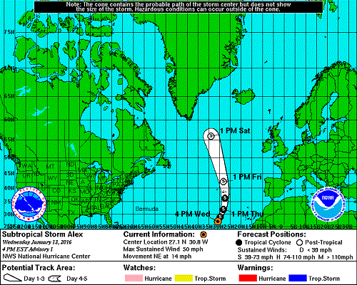
Ladies and gentlemen, we have our first Atlantic storm of the season, Subtropical Storm Alex! The last time we had a tropical storm in the Atlantic in January was in 2006 with Tropical Storm Zeta, however, Zeta was a carry-over from the record active 2005 Atlantic Hurricane season and actually formed in December 2005 lasting until January 7th, 2006. The last storm to actually form in the month of January was in 1978.
However, Alex poses no threat to the U.S., but interest in the Azores islands should be prepared for gusty winds and heavy rain by the end of this week as Alex heads in a northerly direction.
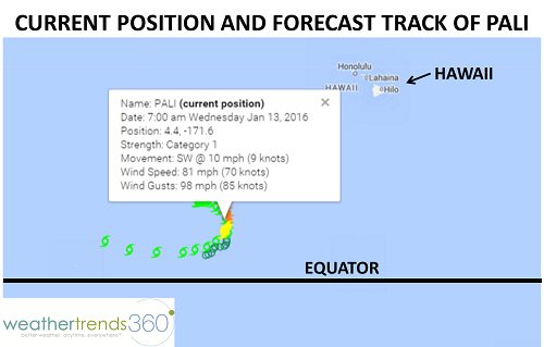
Speaking of the tropics, we have another rather unusual event taking place, this one in the central Pacific and goes by the name of Hurricane Pali. Hurricane Pali is located approximately 1,500 miles southwest of Honolulu, HI and is headed south-southwest. Pali has already set a couple of records including the earliest hurricane on record in the central Pacific Ocean (which it set on January 11th), and Pali is also the southern-most hurricane to exists in the Northern/Western Hemisphere, or in other words, it has had the closet approach to the equator.
Today, Pali is located at latitude 4.2N and forecast to dip even closer to the equator over the next 48 hours, although likely weakening to a Tropical Storm by then. Tropical meteorologists hearts are fluttering as this tropical system makes the closest approach to the equator ever and some theorize (or hope, rather) that Pali could be the first system on record to cross the equator into the Southern Hemisphere. But what would happen then? Actually, we're not entirely sure what exactly would happen once the storm crossed the equator as there are no records of this ever occurring, but likely, it would be torn apart as the spin of the storm would now be opposing the direction Coriolis effect in the Southern Hemisphere, although the storm may maintain its direction of rotation until getting farther away from the equator since the Coriolis effect is stronger the farther away from the equator you are.
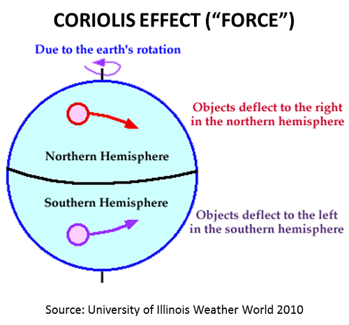
So why don't we usually see hurricanes near the equator? It's all about the rotation, or spin, of the storm. At the equator, Coriolis is zero, while Coriolis is maxed out at the poles. In the absence of the Coriolis Effect, it's difficult to get air to rotate around a low pressure center, instead, the air prefers to flow from high pressure to low pressure. In Pali's case, the storm actually developed within 5 degrees latitude of the equator, something many meteorologists had theorized was not possible, but then moved north and strengthened before heading back south again on its current trajectory.
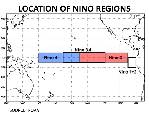
Another interesting fact about Pali is that it's located in one of the Nino regions, Nino 4. Nino regions are where El Nino intensities are measured and consist of 4 areas in the equatorial Pacific depicted in the image below: Nino 1+2, Nino 3, Nino 3.4 and Nino 4. El Nino intensity is based on sea surface temperature anomalies exceeding a pre-selected threshold in one of these regions, usually Nino 3.4.
Regardless of what records Pali sets and whether or not it crosses the equator, the storm poses no threat to land and is in kind of a no-man's land in the middle of the ocean. So carry on Pali, tropical meteorologists and hurricane enthusiasts alike want to see what you can do!
However, Alex poses no threat to the U.S., but interest in the Azores islands should be prepared for gusty winds and heavy rain by the end of this week as Alex heads in a northerly direction.

Speaking of the tropics, we have another rather unusual event taking place, this one in the central Pacific and goes by the name of Hurricane Pali. Hurricane Pali is located approximately 1,500 miles southwest of Honolulu, HI and is headed south-southwest. Pali has already set a couple of records including the earliest hurricane on record in the central Pacific Ocean (which it set on January 11th), and Pali is also the southern-most hurricane to exists in the Northern/Western Hemisphere, or in other words, it has had the closet approach to the equator.
Today, Pali is located at latitude 4.2N and forecast to dip even closer to the equator over the next 48 hours, although likely weakening to a Tropical Storm by then. Tropical meteorologists hearts are fluttering as this tropical system makes the closest approach to the equator ever and some theorize (or hope, rather) that Pali could be the first system on record to cross the equator into the Southern Hemisphere. But what would happen then? Actually, we're not entirely sure what exactly would happen once the storm crossed the equator as there are no records of this ever occurring, but likely, it would be torn apart as the spin of the storm would now be opposing the direction Coriolis effect in the Southern Hemisphere, although the storm may maintain its direction of rotation until getting farther away from the equator since the Coriolis effect is stronger the farther away from the equator you are.

So why don't we usually see hurricanes near the equator? It's all about the rotation, or spin, of the storm. At the equator, Coriolis is zero, while Coriolis is maxed out at the poles. In the absence of the Coriolis Effect, it's difficult to get air to rotate around a low pressure center, instead, the air prefers to flow from high pressure to low pressure. In Pali's case, the storm actually developed within 5 degrees latitude of the equator, something many meteorologists had theorized was not possible, but then moved north and strengthened before heading back south again on its current trajectory.

Another interesting fact about Pali is that it's located in one of the Nino regions, Nino 4. Nino regions are where El Nino intensities are measured and consist of 4 areas in the equatorial Pacific depicted in the image below: Nino 1+2, Nino 3, Nino 3.4 and Nino 4. El Nino intensity is based on sea surface temperature anomalies exceeding a pre-selected threshold in one of these regions, usually Nino 3.4.

Regardless of what records Pali sets and whether or not it crosses the equator, the storm poses no threat to land and is in kind of a no-man's land in the middle of the ocean. So carry on Pali, tropical meteorologists and hurricane enthusiasts alike want to see what you can do!