18 Jan '25 Captain's Blog: FRIGID & Snowy!
Captain's Log
18 Jan '25: Happy Saturday :)
For wt360 clients, reach out to your support rep if you haven't seen our quarterly severe weather outlooks for all of 2025. Sadly, the Winter summary report explicitly called for another historic early start to what will be the worst wildfire season in 10 years. CLICK ON IMAGES FOR A LARGER VIEW.
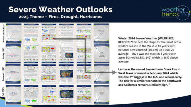
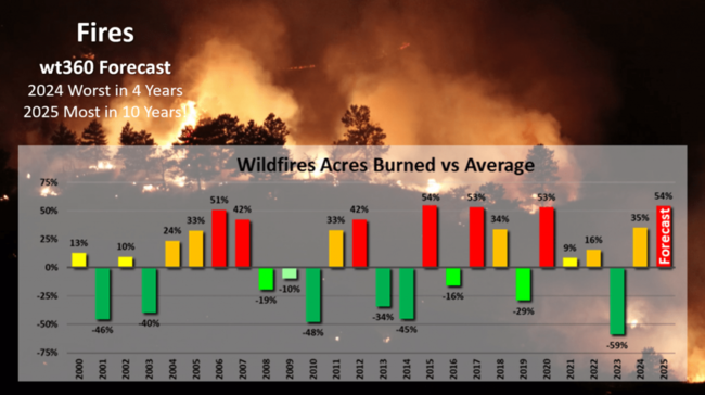
Acres burned are expected to top over 10M this year which is +54% above average and the most in 10 years. With two exceptionally wet and snowy Winters in 2022-2023, underbrush is prolific and that has now drier out = fuel for more historic fires all year long.
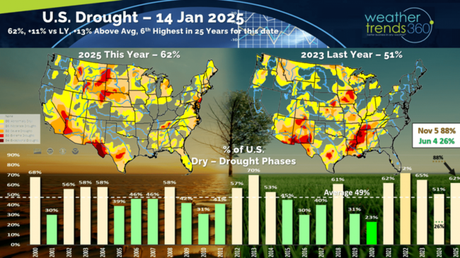
Drought is also expanding again in the West and across the Northern tier of the U.S. Recall in 2024 it was a crazy swing from the flooding Spring with on 26% of the U.S. in drought phases and then surged to near historic highs of 88% in drought phases on 5 November 2024 and now down a bit at 62%. 49% is average for this time of year.
For our hundreds of FarmCast farmers, your page 5 zip code specific farm recommendations are live. Don't forget this Spring to set your planting date on the website version of FarmCast so your daily email reports track your rain, GDDs and crop milestone forecast dates.
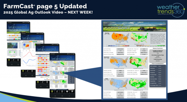
Look for our 2025 Global Ag outlook next week!
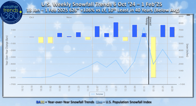
U.S. weekly snowfall showed a dip last week, but now the second snowiest week of Winter on the way this week.
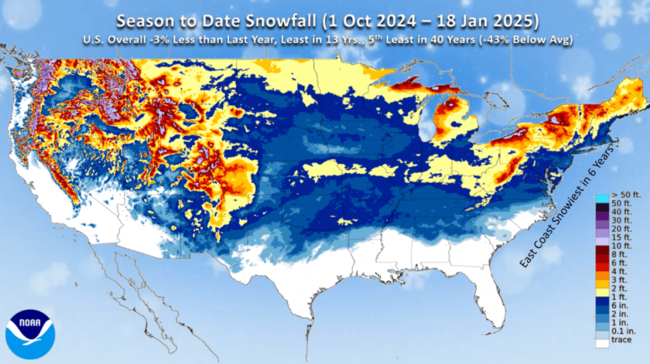
NOAA's U.S. season to date snowfall is widespread, but it's still -3% less than last year, least in 13 years and 5th least of the past 40 years trending -43% below average nationally. The East Coast is the biggest winner, trending the snowiest in 6 years and closer to average.
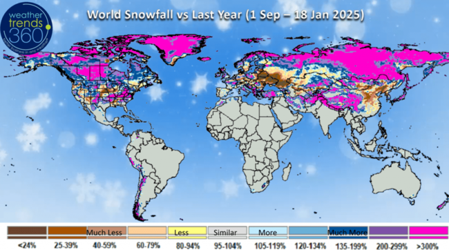
World seasonal snowfall trends show the South and Eastern U.S. trending over 300% snow than a year ago.
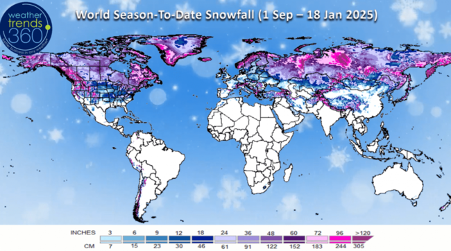
Central Canada, Siberia and Western China also trending 3x more snow than a year ago. Way down in the Western U.S. and Midwest.
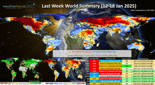
Last week (12-18 Jan) across the World shows the U.S. trending +8.1F warmer than last year but still 13th coldest of the past 40 years with below average national temperatures. This week last year was the one time the Polar Vortex invaded the U.S. with a brief shot of very cold weather. -66% drier than last year, driest in 16 years and 4th driest of the past 40 years for the U.S. overall, while snowfall was -75% vs LY, least in 8 years and 7th least of the past 40 years. The huge Winter seasonal sales gains that occurred in middle January last year with the Polar Vortex have been split up to middle December, early January and now the 3rd week of January which should net much stronger sales than a year ago. Most of the World was warmer other than Brazil that was cool and wet benefiting their crops. Still hot and dry for Argentina's crops.
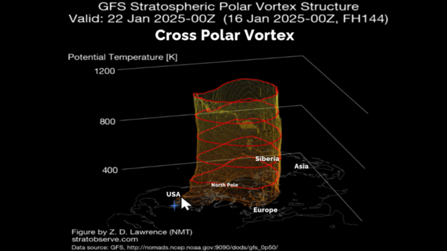
The Polar Vortex is relatively strong and symmetrical, but it's elongated in a pattern called a cross Polar Vortex flow allowing brutally cold Arctic air to grip the entire U.S.
This week (19-25 Jan) shows nearly the entire U.S. in a deep freeze with national temperatures trending -11.6F colder than last year, coldest in 17 years and 2nd coldest of the past 40 years. Seasonal category sales gains will be exceptional, especially the Deep South and East Coast. Snowfall up +74% vs last year and 17th most of the past 40 years, while rainfall is down -72%, driest in 11 years and 7th least of the past 40 years.
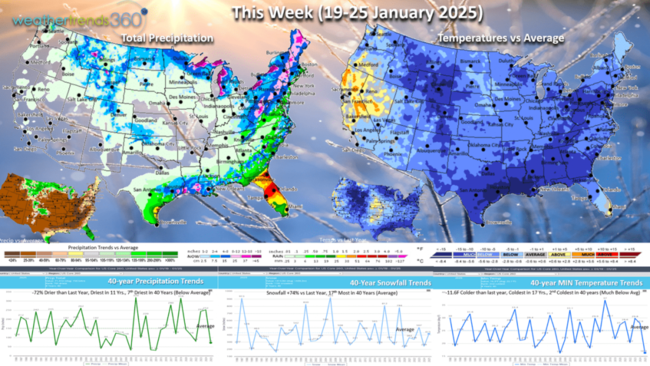
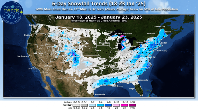
There are two snowstorm threats over the next 6-days with one moderate snow event for the Northeast and a very unusual Deep South Gulf Coast snow/ice event later this week. This will bring exceptional sales gains for snow accessories. Some uncertainty if this Deep South storm will hug the East Coast with heavier snow than currently forecast. Either way temperatures will dip below zero even in the Middle Atlantic.
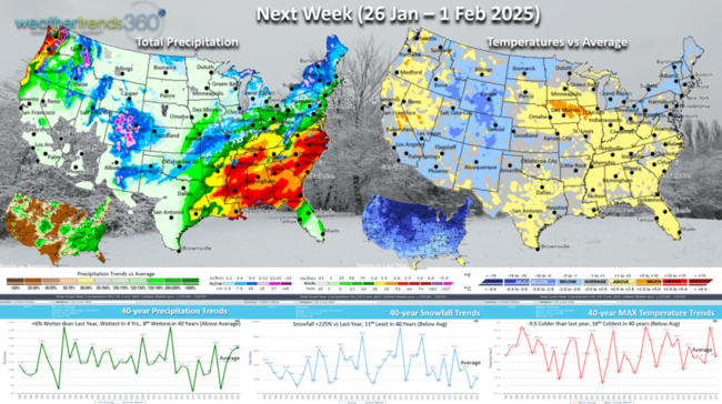
Next week (26 Jan - 1 Feb) shows a bit of a moderating trend, but still -9.5F colder than last year, 16th coldest of the past 40 years with below average national temperatures. Snowfall again up a bit +225% over LY but that's still 11th least in 40 years.
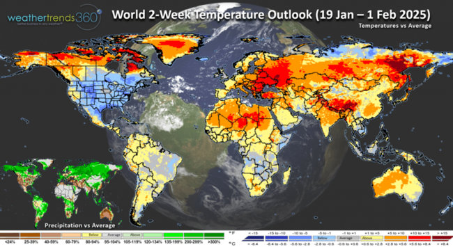
The World 2-week outlook (19 Jan - 1 Feb) shows the U.S. and Canada are the cold spots while Europe, Russian and China are very warm.
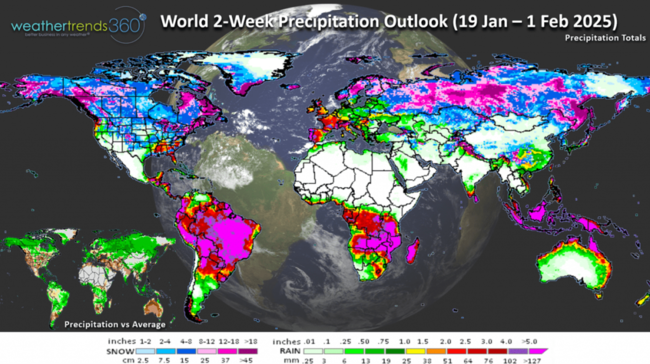
World Precipitation outlook (19 Jan - 1 Feb) shows a more active stormy pattern for the Eastern and Southern U.S. while it remains very dry in the Southwest.
Have a great week ahead, and don't forget to follow us on social media for frequent updates: Facebook, Twitter, YouTube, Pinterest and Linkedin.
- Captain Kirk out
For wt360 clients, reach out to your support rep if you haven't seen our quarterly severe weather outlooks for all of 2025. Sadly, the Winter summary report explicitly called for another historic early start to what will be the worst wildfire season in 10 years. CLICK ON IMAGES FOR A LARGER VIEW.

Acres burned are expected to top over 10M this year which is +54% above average and the most in 10 years. With two exceptionally wet and snowy Winters in 2022-2023, underbrush is prolific and that has now drier out = fuel for more historic fires all year long.

Drought is also expanding again in the West and across the Northern tier of the U.S. Recall in 2024 it was a crazy swing from the flooding Spring with on 26% of the U.S. in drought phases and then surged to near historic highs of 88% in drought phases on 5 November 2024 and now down a bit at 62%. 49% is average for this time of year.

For our hundreds of FarmCast farmers, your page 5 zip code specific farm recommendations are live. Don't forget this Spring to set your planting date on the website version of FarmCast so your daily email reports track your rain, GDDs and crop milestone forecast dates.

Look for our 2025 Global Ag outlook next week!

U.S. weekly snowfall showed a dip last week, but now the second snowiest week of Winter on the way this week.

NOAA's U.S. season to date snowfall is widespread, but it's still -3% less than last year, least in 13 years and 5th least of the past 40 years trending -43% below average nationally. The East Coast is the biggest winner, trending the snowiest in 6 years and closer to average.

World seasonal snowfall trends show the South and Eastern U.S. trending over 300% snow than a year ago.

Central Canada, Siberia and Western China also trending 3x more snow than a year ago. Way down in the Western U.S. and Midwest.

Last week (12-18 Jan) across the World shows the U.S. trending +8.1F warmer than last year but still 13th coldest of the past 40 years with below average national temperatures. This week last year was the one time the Polar Vortex invaded the U.S. with a brief shot of very cold weather. -66% drier than last year, driest in 16 years and 4th driest of the past 40 years for the U.S. overall, while snowfall was -75% vs LY, least in 8 years and 7th least of the past 40 years. The huge Winter seasonal sales gains that occurred in middle January last year with the Polar Vortex have been split up to middle December, early January and now the 3rd week of January which should net much stronger sales than a year ago. Most of the World was warmer other than Brazil that was cool and wet benefiting their crops. Still hot and dry for Argentina's crops.

The Polar Vortex is relatively strong and symmetrical, but it's elongated in a pattern called a cross Polar Vortex flow allowing brutally cold Arctic air to grip the entire U.S.

This week (19-25 Jan) shows nearly the entire U.S. in a deep freeze with national temperatures trending -11.6F colder than last year, coldest in 17 years and 2nd coldest of the past 40 years. Seasonal category sales gains will be exceptional, especially the Deep South and East Coast. Snowfall up +74% vs last year and 17th most of the past 40 years, while rainfall is down -72%, driest in 11 years and 7th least of the past 40 years.

There are two snowstorm threats over the next 6-days with one moderate snow event for the Northeast and a very unusual Deep South Gulf Coast snow/ice event later this week. This will bring exceptional sales gains for snow accessories. Some uncertainty if this Deep South storm will hug the East Coast with heavier snow than currently forecast. Either way temperatures will dip below zero even in the Middle Atlantic.

Next week (26 Jan - 1 Feb) shows a bit of a moderating trend, but still -9.5F colder than last year, 16th coldest of the past 40 years with below average national temperatures. Snowfall again up a bit +225% over LY but that's still 11th least in 40 years.

The World 2-week outlook (19 Jan - 1 Feb) shows the U.S. and Canada are the cold spots while Europe, Russian and China are very warm.

World Precipitation outlook (19 Jan - 1 Feb) shows a more active stormy pattern for the Eastern and Southern U.S. while it remains very dry in the Southwest.

Have a great week ahead, and don't forget to follow us on social media for frequent updates: Facebook, Twitter, YouTube, Pinterest and Linkedin.
- Captain Kirk out