10 May '25 Captain's Blog: May Holidays SOFT Weather Wise
Captain's Log
10 May '25: Happy Saturday! :)
It was a busy week here at wt36o as we headed to the World of DaaS AI Summit in Washington D.C. Met some great business leaders, congressmen, FBI Will Rivers, Associate Deputy Director, FBI; Robert Cardillo, Fmr Director, National Geospatial-Intelligence Agency and 3-star, soon to be 4-star General Alex Grynkewich Director for Operations Joint Staff. See today's video for the highlights. CLICK ON IMAGES FOR A LARGER VIEW.

We also reviewed Q1 and Q2 weather trends for our financial services clients and the news is generally SOFT with tough YOY comparisons.
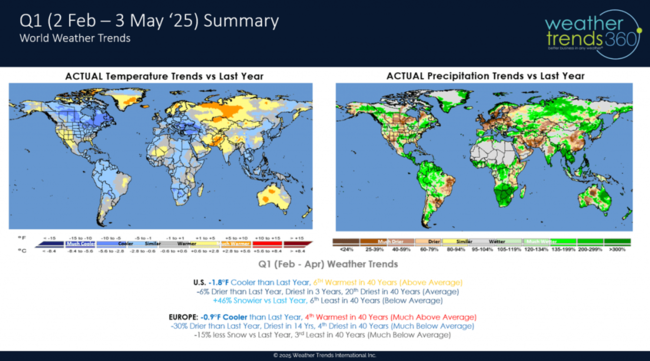
Q1 (Feb - Apr) started off really tough in February but middle March and late April were bright spots. Warmer/Drier YOY is better, so there were a few good weeks.

Q2 (May - Jul) is starting off on the cooler/wetter side with the first big holiday - Mother's Day not as good as last year.

The National weekly YOY trends show very few warmer/drier weeks the front half of 2025 so retail seasonal sales likely to be flat to down until more favorable trends develop in middle to late Fall.
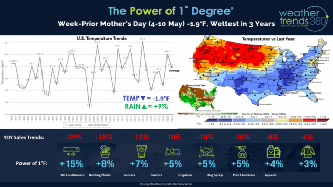
Mothers' Day week-prior shows a cooler and wetter week from New Mexico to New England while the Pacific Northwest baked in warm/dry weather. Our Power of 1 Degree technology quantifies the influence of weather on seasonal sales - all generally in the -6% to -29% vs last year.

Severe weather continues to trend the most in 8-14 years for tornadoes, wind and hail.
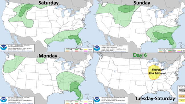
The week-ahead severe weather outlook shows fewer threats with the Southeast the slightly higher risk region until late week when the Midwest could get a round of stronger thunderstorms.
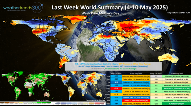
Last week (4-10 May) across the World shows the U.S. trending -1.9F cooler than last year, coolest in 4 years but 17th warmest of the past 40 years. Overall a negative trend for Mother's Day sales and especially the Northeast. The Northeast has gone from drought to floods overnight with May now off to the wettest start in 27 years! Hot 90F days nationally were down -64% vs last year, least in 6 years and 12th least in 40 years. Rainfall was down -5% but still 6th wettest of the past 40 years. Much cooler conditions across the U.K. and in Central Europe. On the World scale it was the #1 wettest in 40+ years.

This week (11-17 May) the weather pattern begins to move with much cooler conditions invading the West, while the Plains and East warm up. The U.S. overall trends +2.2F warmer than last year, warmest in 3 years and 5th warmest in 40 years. Hot 90F days are up (mostly in the Central U.S.) trending +58% more than last year, most in 3 years and 3rd most in 40 years. This will drive some hot Summer seasonal categories like AC, pool supplies and cold beverages. While the East is warmer, it remains very wet with +8% more rain than last year nationally, the most in 10 years and 7th most in 40 years.
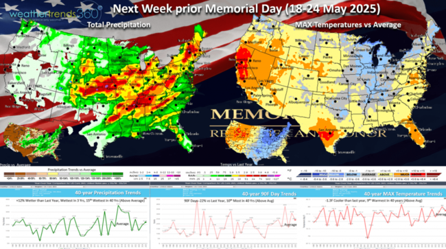
Next week prior Memorial Day weekend (18-24 May) the transient weather pattern continues with much warmer conditions moving back to the West while the Midwest and eventually East Coast turn cooler. The U.S. overall trends -1.3F cooler than last year, hot 90F days down -22% vs LY and rainfall +12% wetter than LY...all generally soft trends for seasonal category sales trends vs last year when it was the hottest in 6 years.
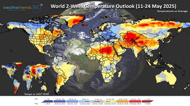
The World 2-week Temperature outlook (11-24 May) is a little misleading since the weather pattern is moving again and transient going from cool to hot to cool. Central and Eastern Europe remain on the cool side.

The World 2-week Precipitation outlook (11-24 May) shows the heaviest rain in Southeast and East Coast of the U.S. Warm and Dry conditions for Brazil's growing regions and their 2nd crops.
Have a great week, and don't forget to follow us on social media for frequent updates: Facebook, Twitter, YouTube, Pinterest and Linkedin.
- Captain Kirk out
It was a busy week here at wt36o as we headed to the World of DaaS AI Summit in Washington D.C. Met some great business leaders, congressmen, FBI Will Rivers, Associate Deputy Director, FBI; Robert Cardillo, Fmr Director, National Geospatial-Intelligence Agency and 3-star, soon to be 4-star General Alex Grynkewich Director for Operations Joint Staff. See today's video for the highlights. CLICK ON IMAGES FOR A LARGER VIEW.

We also reviewed Q1 and Q2 weather trends for our financial services clients and the news is generally SOFT with tough YOY comparisons.

Q1 (Feb - Apr) started off really tough in February but middle March and late April were bright spots. Warmer/Drier YOY is better, so there were a few good weeks.
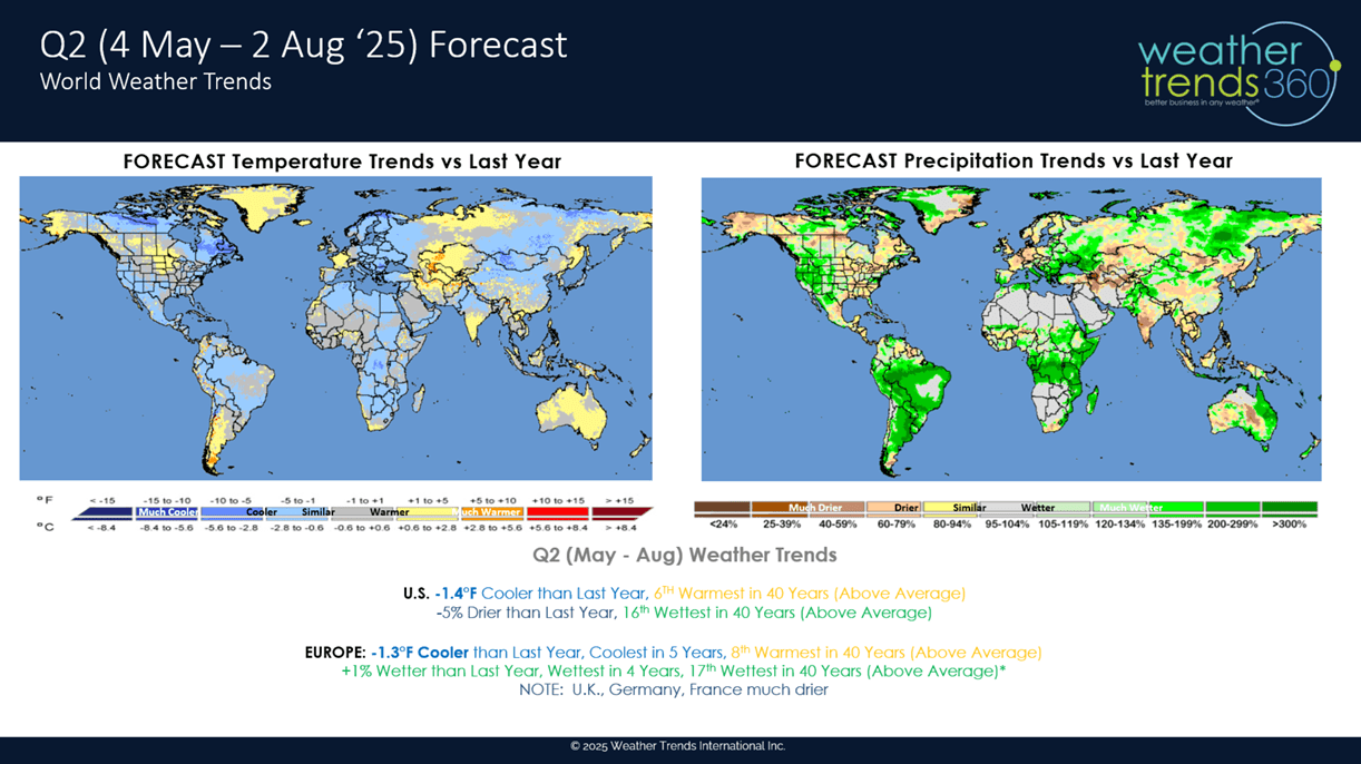
Q2 (May - Jul) is starting off on the cooler/wetter side with the first big holiday - Mother's Day not as good as last year.
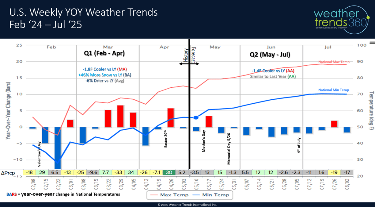
The National weekly YOY trends show very few warmer/drier weeks the front half of 2025 so retail seasonal sales likely to be flat to down until more favorable trends develop in middle to late Fall.
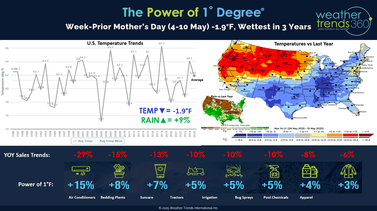
Mothers' Day week-prior shows a cooler and wetter week from New Mexico to New England while the Pacific Northwest baked in warm/dry weather. Our Power of 1 Degree technology quantifies the influence of weather on seasonal sales - all generally in the -6% to -29% vs last year.
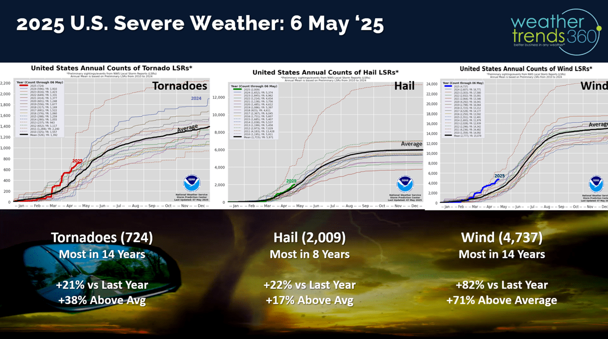
Severe weather continues to trend the most in 8-14 years for tornadoes, wind and hail.
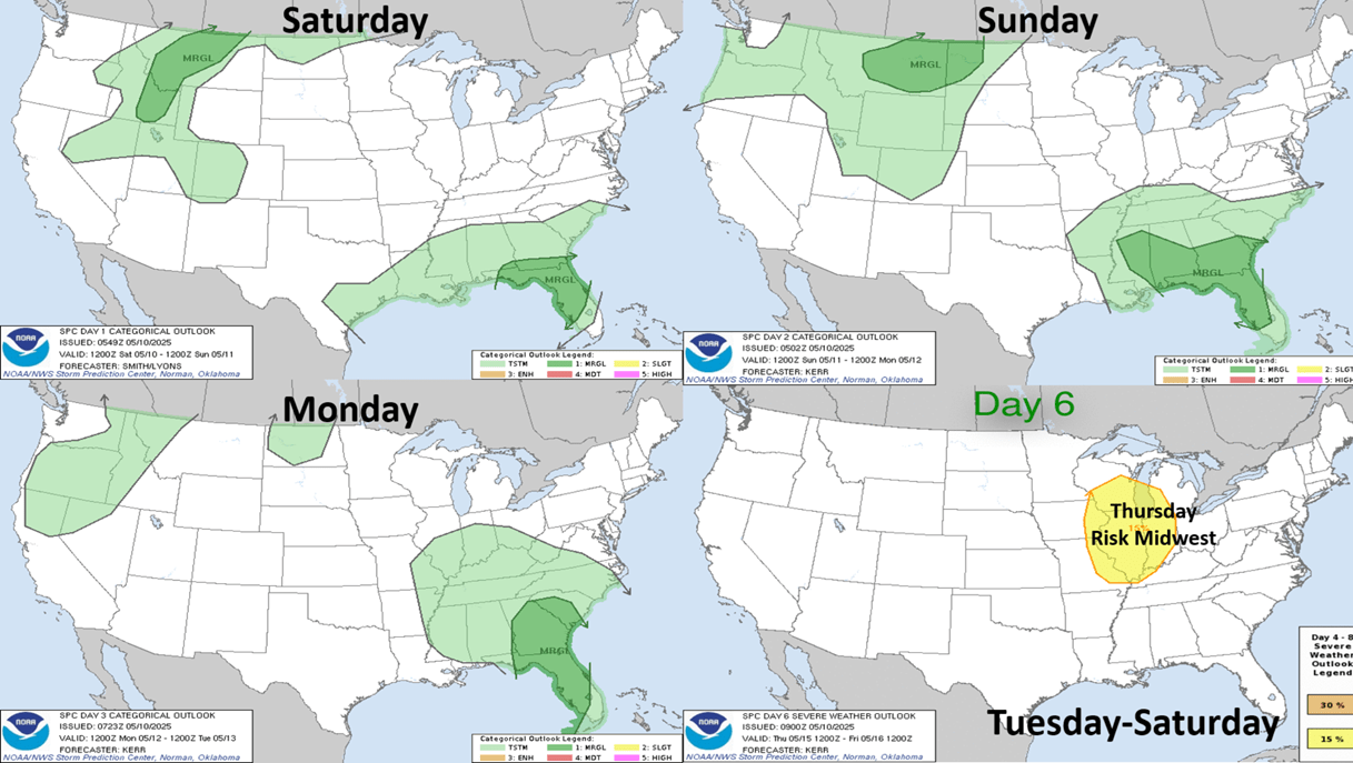
The week-ahead severe weather outlook shows fewer threats with the Southeast the slightly higher risk region until late week when the Midwest could get a round of stronger thunderstorms.

Last week (4-10 May) across the World shows the U.S. trending -1.9F cooler than last year, coolest in 4 years but 17th warmest of the past 40 years. Overall a negative trend for Mother's Day sales and especially the Northeast. The Northeast has gone from drought to floods overnight with May now off to the wettest start in 27 years! Hot 90F days nationally were down -64% vs last year, least in 6 years and 12th least in 40 years. Rainfall was down -5% but still 6th wettest of the past 40 years. Much cooler conditions across the U.K. and in Central Europe. On the World scale it was the #1 wettest in 40+ years.
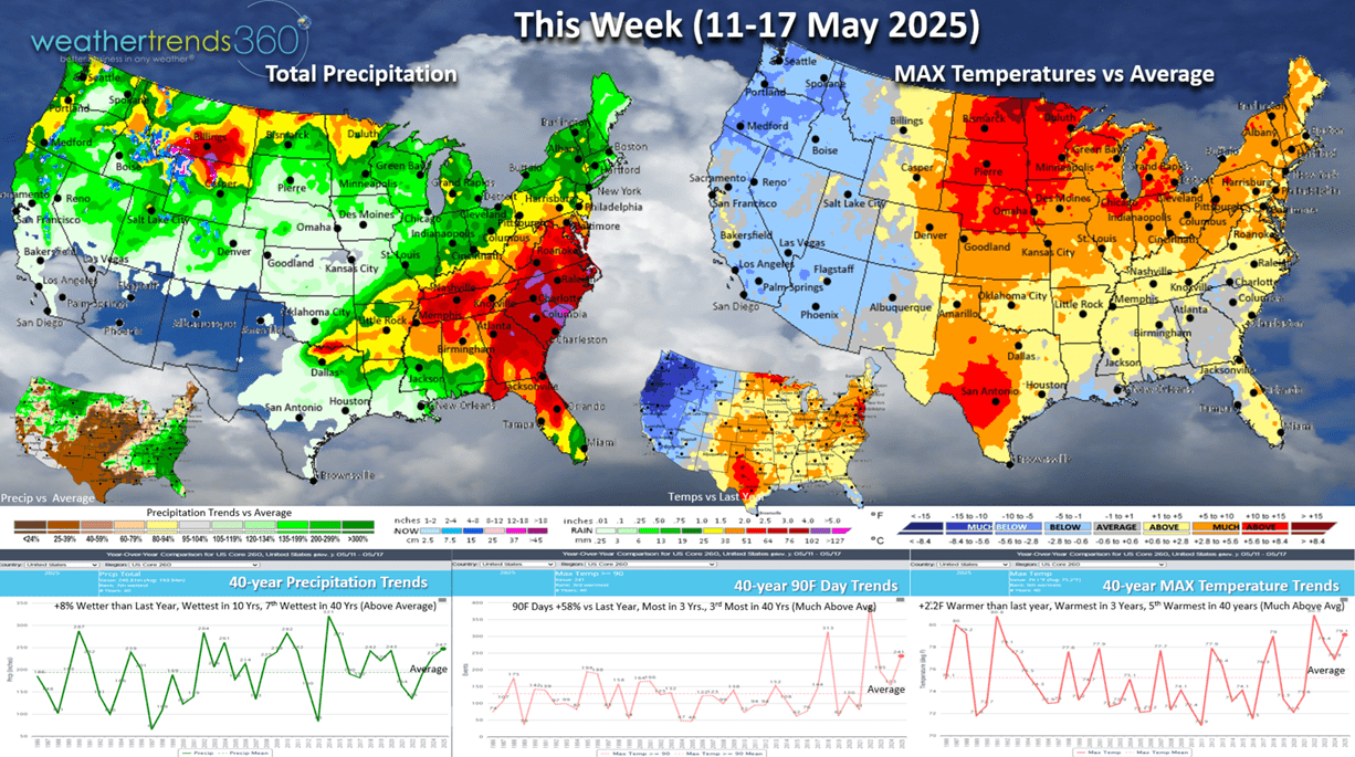
This week (11-17 May) the weather pattern begins to move with much cooler conditions invading the West, while the Plains and East warm up. The U.S. overall trends +2.2F warmer than last year, warmest in 3 years and 5th warmest in 40 years. Hot 90F days are up (mostly in the Central U.S.) trending +58% more than last year, most in 3 years and 3rd most in 40 years. This will drive some hot Summer seasonal categories like AC, pool supplies and cold beverages. While the East is warmer, it remains very wet with +8% more rain than last year nationally, the most in 10 years and 7th most in 40 years.

Next week prior Memorial Day weekend (18-24 May) the transient weather pattern continues with much warmer conditions moving back to the West while the Midwest and eventually East Coast turn cooler. The U.S. overall trends -1.3F cooler than last year, hot 90F days down -22% vs LY and rainfall +12% wetter than LY...all generally soft trends for seasonal category sales trends vs last year when it was the hottest in 6 years.

The World 2-week Temperature outlook (11-24 May) is a little misleading since the weather pattern is moving again and transient going from cool to hot to cool. Central and Eastern Europe remain on the cool side.
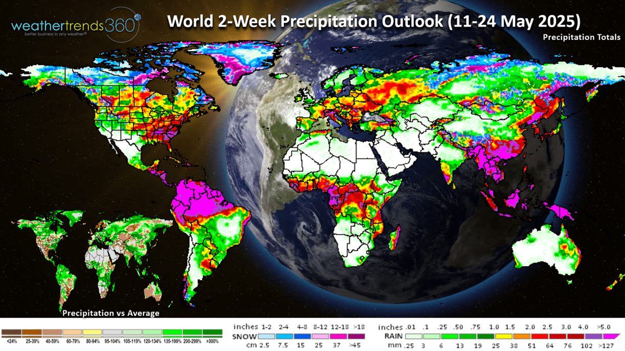
The World 2-week Precipitation outlook (11-24 May) shows the heaviest rain in Southeast and East Coast of the U.S. Warm and Dry conditions for Brazil's growing regions and their 2nd crops.
Have a great week, and don't forget to follow us on social media for frequent updates: Facebook, Twitter, YouTube, Pinterest and Linkedin.
- Captain Kirk out