10 Jan '26 wt360 Weather Brief - January Thaw Followed By Return of the Polar Vortex
Captain's Log
10 Jan '26: Happy New Year! No video this week as Captain Kirk is off on a secret "mission", but don't worry, he'll be back soon!
It's been a few weeks since our last update as we took some time to celebrate the holidays with our families, rest, and recharge for an exciting 2026! We have a lot of exciting things in the works at wt360 for the new year and we're ready to go!
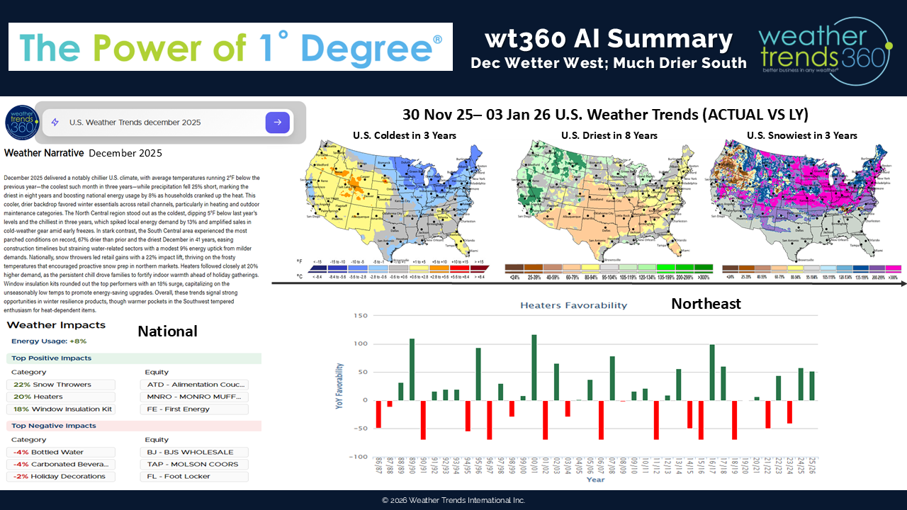
Today's wt360 AI summary for December 2025 shows that this was the coldest December in 3 years, the driest in 8 years, and snowiest in 3 years for the United States as a whole. Colder trends in the North Central and Northeast states were favorable for Winter merchandise with Space Heaters likely seeing double-digit sales gains on last year.
Snowier conditions will have also propelled demand for Snow categories, like snow throwers and ice melt. Meanwhile, warmer trends in the West were a headwind for Winter categories and wet weather was disruptive with flash flooding at times during December. The South Central and Southeast states will have seen the best conditions for in-store traffic with much drier trends than last year.
U.S. Season-to-date snowfall is trending +13% more than last year, the most in 3 years but the 13th least in 40 years, which is -16% below average, nationally. Areas downwind of the Great Lakes saw a surge in snowfall towards the end of December as several feet of snow fell across the snow belts.
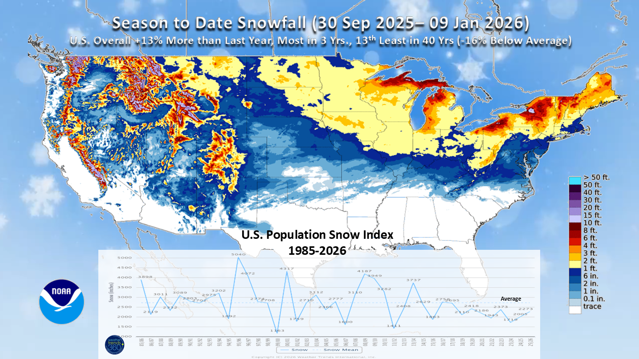
Some minor increases in the Mid-Atlantic and Northeast season-to-date snowfall since mid-December as a messy ice storm moved through Pennsylvania, New Jersey, and New England the day after Christmas.
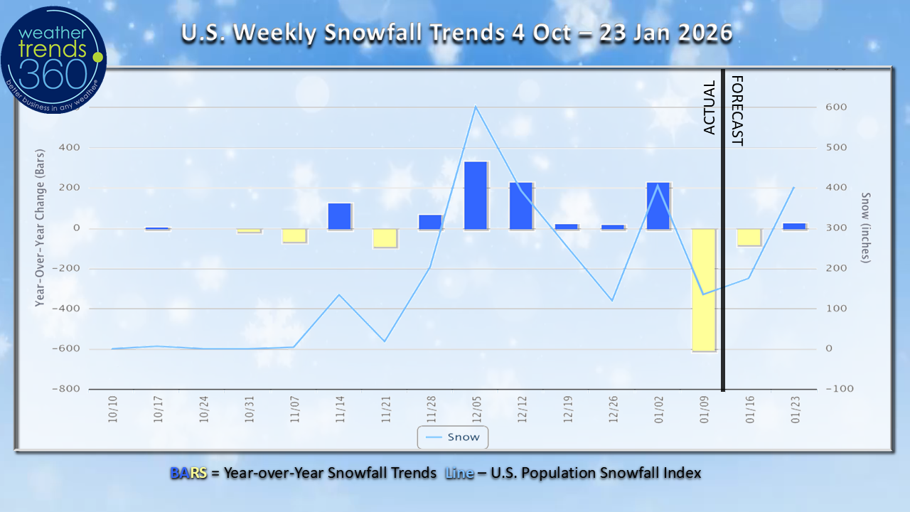
Weekly Snowfall trends show the snowier year-over-year pattern in much of December with a brief lull here to start January, but fear not snow lovers! Winter is far from over.
Last Week (04-10 Jan) across the World shows the U.S. trending the 1st warmest in 40 years as January started off with a 'January Thaw' across a large portion of the nation. Temperatures trended a whooping +14.6F warmer than last year; recall that last year, the first 3 weeks of January were quite cold across the U.S. so it was a wholesale change from last year to start January 2026.
Snowfall was down -78% vs last year and the 5th least in 40 years. Some early season severe weather activity in the Lower Mississippi River Valley and Tennessee Valley late in the week with a couple tornadoes reported.
In Texas and parts of Oklahoma, warm, dry, and, at times, windy weather supported elevated tree pollen counts which likely caused increased incidences of allergy suffering.
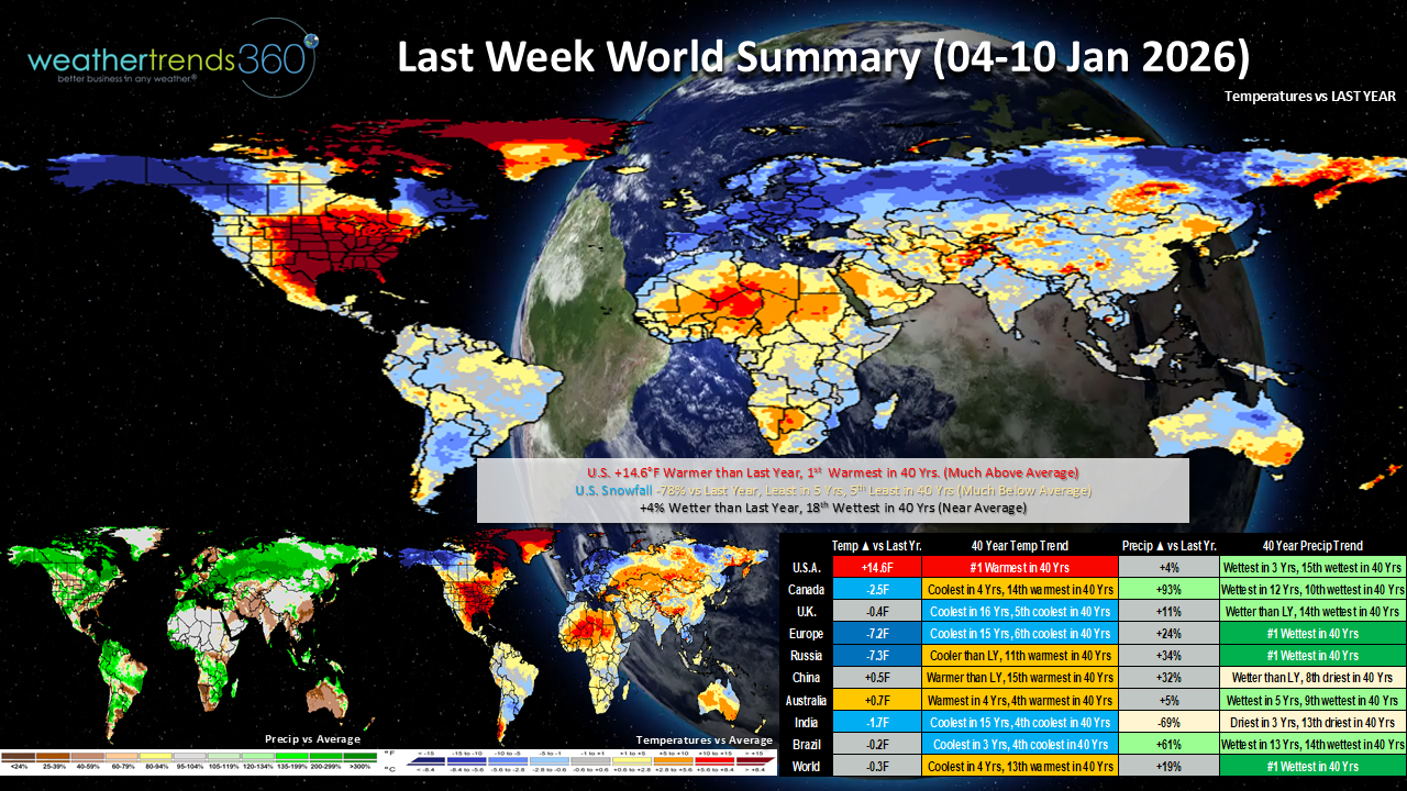
Much colder than last year in Europe where this was the 6th coldest first week of January in 40 years. A massive clean-up is underway following Storm Goretti which unleashed hurricane-force winds, heavy rain, and snow across the United Kingdom, France, and Germany in the second half of the week. Goretti caused travel disruptions and power outages. Winds reportedly gusted over 120 mph in the Southwest of England. Similarly strong winds were reported on the other side of the English Channel along the coast of France resulting in power cuts to hundreds of thousands of customers. Snow in Wales, the Midlands of England, and northern England with as much as 8-10'' over some of the higher ground of Wales and the West Midlands. Storm Goretti contributed to one of the wettest first weeks of January in 40 years for Europe.
Unsettled weather also battered other portions of Europe with some areas see snow and ice as cold gripped the continent. In Rome, Italy more rain fell resulting in swelling rivers and flooding as a wet weather pattern has persisted since before Christmas.
This Week (11-17 Jan) shows warmer trends are set to continue across much of the U.S. with the U.S. overall trending +6F warmer than last year and the warmest in 3 years. Snowfall trends are currently showing as the 10th least in 40 years. HOWEVER, we will see a change in the weather pattern around the middle of the week. All eyes are on the Polar Vortex in the second half of January as it weakens and increases the possibility of surges of Arctic air across the globe. Of course, the question is always 'where does the cold air end up', but models have been very consistent with colder air returning to the U.S. within the next 2 weeks. Towards the middle of this week, a surge of cold air looks intent on pushing down across the eastern U.S. with increasing risks of snow and ice accompanying the frigid blast. We'll need to watch the East Coast in the Thursday-Saturday time frame for a the potential for a more significant snow storm.
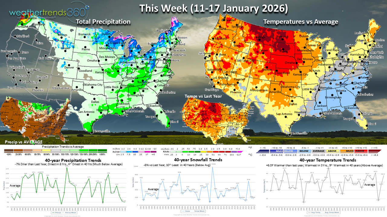
Drier weather in the South with mild, but not quite as mild as last week, weather across Texas where residents may need to keep the allergy medication nearby (tis' the season for tree pollen!). After a somewhat cooler start to January in the West, temperatures are set to turn warmer and drier. Early spring categories could see some elevated interest, especially across the Southwest where this is forecast to be the 5th warmest second week of January in 40 years.
Next Week (18-24 Jan) shows a firm turn to colder trends in the East while the West is warmer. The U.S. overall trends +9.5F warmer than last year, but as mentioned earlier, we're comparing to some very cold trends last year; in fact we're comparing to one of the coldest third weeks of January in 40 years last year, so while it's much warmer this year, it may be colder than normal, especially in the East. There may be some brief moderation in temperatures in the East before another surge of colder air takes over by the end of the week. Winter category demand will be up against some tough comparisons to a very cold week last year across the nation.
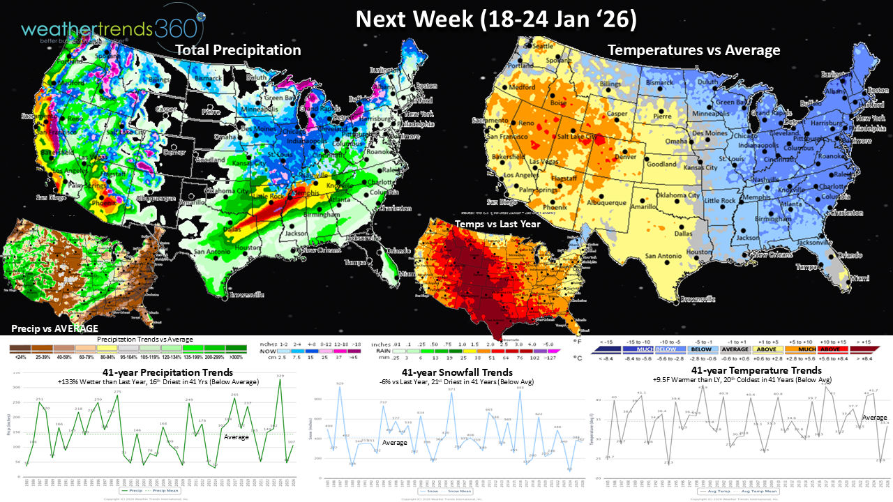
The snowfall trends are currently showing -6%, again, we'll see if this verifies with both early and late week possibilities of snowfall.
Milder weather is more favorable for store traffic this time of year, although we're in one of the, historically, slowest times of the year for retail. Energy usage is likely to be increased in the East while decreased in the West.
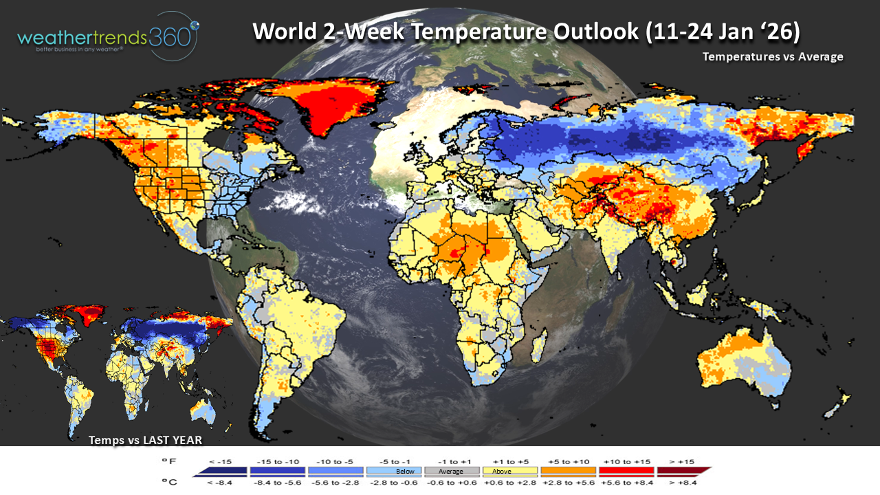
The World 2-week Temperature Outlook (11-24 Jan) shows the expected colder trends in the eastern U.S. and warmer weather in the West. Europe will see a reprieve from the recent cold conditions, although it may remain unsettled. Much of Asia looks to trend warmer than normal in the next 2 weeks overall.
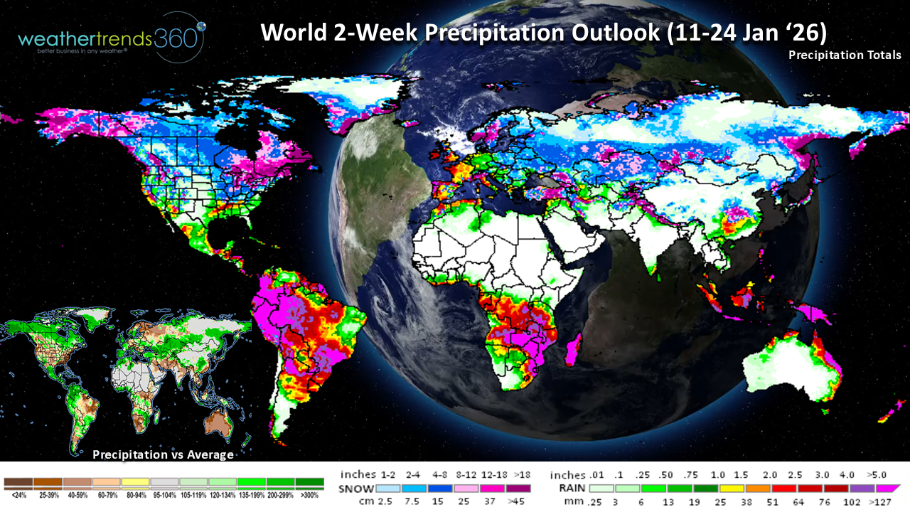
The World 2-week Precipitation Outlook (11-24 Jan) shows more unsettled weather expected across Europe, although less of this should be snow and ice as compared to last week. Favorable rains are expected to continue in southern Brazil and Argentina for corn and soybean crops puts downward pressure on prices.
You can get this blog/video in your email inbox every Saturday (FREE) via subscription.
Have a great week ahead, and don't forget to follow us on social media for updates: Facebook, Twitter(X), YouTube, Pinterest and Linkedin.
-Co-Captain Krissy signing off!
It's been a few weeks since our last update as we took some time to celebrate the holidays with our families, rest, and recharge for an exciting 2026! We have a lot of exciting things in the works at wt360 for the new year and we're ready to go!
Today's wt360 AI summary for December 2025 shows that this was the coldest December in 3 years, the driest in 8 years, and snowiest in 3 years for the United States as a whole. Colder trends in the North Central and Northeast states were favorable for Winter merchandise with Space Heaters likely seeing double-digit sales gains on last year.
Snowier conditions will have also propelled demand for Snow categories, like snow throwers and ice melt. Meanwhile, warmer trends in the West were a headwind for Winter categories and wet weather was disruptive with flash flooding at times during December. The South Central and Southeast states will have seen the best conditions for in-store traffic with much drier trends than last year.
U.S. Season-to-date snowfall is trending +13% more than last year, the most in 3 years but the 13th least in 40 years, which is -16% below average, nationally. Areas downwind of the Great Lakes saw a surge in snowfall towards the end of December as several feet of snow fell across the snow belts.
Some minor increases in the Mid-Atlantic and Northeast season-to-date snowfall since mid-December as a messy ice storm moved through Pennsylvania, New Jersey, and New England the day after Christmas.
Weekly Snowfall trends show the snowier year-over-year pattern in much of December with a brief lull here to start January, but fear not snow lovers! Winter is far from over.
Last Week (04-10 Jan) across the World shows the U.S. trending the 1st warmest in 40 years as January started off with a 'January Thaw' across a large portion of the nation. Temperatures trended a whooping +14.6F warmer than last year; recall that last year, the first 3 weeks of January were quite cold across the U.S. so it was a wholesale change from last year to start January 2026.
Snowfall was down -78% vs last year and the 5th least in 40 years. Some early season severe weather activity in the Lower Mississippi River Valley and Tennessee Valley late in the week with a couple tornadoes reported.
In Texas and parts of Oklahoma, warm, dry, and, at times, windy weather supported elevated tree pollen counts which likely caused increased incidences of allergy suffering.
Much colder than last year in Europe where this was the 6th coldest first week of January in 40 years. A massive clean-up is underway following Storm Goretti which unleashed hurricane-force winds, heavy rain, and snow across the United Kingdom, France, and Germany in the second half of the week. Goretti caused travel disruptions and power outages. Winds reportedly gusted over 120 mph in the Southwest of England. Similarly strong winds were reported on the other side of the English Channel along the coast of France resulting in power cuts to hundreds of thousands of customers. Snow in Wales, the Midlands of England, and northern England with as much as 8-10'' over some of the higher ground of Wales and the West Midlands. Storm Goretti contributed to one of the wettest first weeks of January in 40 years for Europe.
Unsettled weather also battered other portions of Europe with some areas see snow and ice as cold gripped the continent. In Rome, Italy more rain fell resulting in swelling rivers and flooding as a wet weather pattern has persisted since before Christmas.
This Week (11-17 Jan) shows warmer trends are set to continue across much of the U.S. with the U.S. overall trending +6F warmer than last year and the warmest in 3 years. Snowfall trends are currently showing as the 10th least in 40 years. HOWEVER, we will see a change in the weather pattern around the middle of the week. All eyes are on the Polar Vortex in the second half of January as it weakens and increases the possibility of surges of Arctic air across the globe. Of course, the question is always 'where does the cold air end up', but models have been very consistent with colder air returning to the U.S. within the next 2 weeks. Towards the middle of this week, a surge of cold air looks intent on pushing down across the eastern U.S. with increasing risks of snow and ice accompanying the frigid blast. We'll need to watch the East Coast in the Thursday-Saturday time frame for a the potential for a more significant snow storm.
Drier weather in the South with mild, but not quite as mild as last week, weather across Texas where residents may need to keep the allergy medication nearby (tis' the season for tree pollen!). After a somewhat cooler start to January in the West, temperatures are set to turn warmer and drier. Early spring categories could see some elevated interest, especially across the Southwest where this is forecast to be the 5th warmest second week of January in 40 years.
Next Week (18-24 Jan) shows a firm turn to colder trends in the East while the West is warmer. The U.S. overall trends +9.5F warmer than last year, but as mentioned earlier, we're comparing to some very cold trends last year; in fact we're comparing to one of the coldest third weeks of January in 40 years last year, so while it's much warmer this year, it may be colder than normal, especially in the East. There may be some brief moderation in temperatures in the East before another surge of colder air takes over by the end of the week. Winter category demand will be up against some tough comparisons to a very cold week last year across the nation.
The snowfall trends are currently showing -6%, again, we'll see if this verifies with both early and late week possibilities of snowfall.
Milder weather is more favorable for store traffic this time of year, although we're in one of the, historically, slowest times of the year for retail. Energy usage is likely to be increased in the East while decreased in the West.
The World 2-week Temperature Outlook (11-24 Jan) shows the expected colder trends in the eastern U.S. and warmer weather in the West. Europe will see a reprieve from the recent cold conditions, although it may remain unsettled. Much of Asia looks to trend warmer than normal in the next 2 weeks overall.
The World 2-week Precipitation Outlook (11-24 Jan) shows more unsettled weather expected across Europe, although less of this should be snow and ice as compared to last week. Favorable rains are expected to continue in southern Brazil and Argentina for corn and soybean crops puts downward pressure on prices.
You can get this blog/video in your email inbox every Saturday (FREE) via subscription.
Have a great week ahead, and don't forget to follow us on social media for updates: Facebook, Twitter(X), YouTube, Pinterest and Linkedin.
-Co-Captain Krissy signing off!